Report on Anatahan (United States) — April 1990
Bulletin of the Global Volcanism Network, vol. 15, no. 4 (April 1990)
Managing Editor: Lindsay McClelland.
Anatahan (United States) Local earthquakes and strong thermal activity; youngest surge deposits appear no more than a few hundred years old
Please cite this report as:
Global Volcanism Program, 1990. Report on Anatahan (United States) (McClelland, L., ed.). Bulletin of the Global Volcanism Network, 15:4. Smithsonian Institution. https://doi.org/10.5479/si.GVP.BGVN199004-284200
Anatahan
United States
16.35°N, 145.67°E; summit elev. 790 m
All times are local (unless otherwise noted)
At the request of the Civil Defense office of the CNMI, a team from the USGS and the Hawaii Institute of Geophysics monitored seismicity, deformation, and thermal activity, and investigated the geologic and eruptive history of the island during fieldwork 19-27 April. The following is from their preliminary report.
Geologic overview. "Anatahan, ~9 km long by 3 km wide and elongate along an E-W axis, is topped by a compound caldera of both collapse and explosive origin. The caldera's shape roughly parallels the outline of the island. It can generally be divided into E and W craters; the floor of the E bay is ~250 m below the floor of the main caldera and contains a lake. The W crater essentially comprises the caldera floor and is made up of at least five phreatomagmatic explosion craters. The two highest points on the volcano are peaks at the E and W ends of the caldera (540 and 790 m above sea level, respectively). Slopes dip steeply to the sea from these high points as well as from the caldera walls, at angles averaging about 25°. A number of extra-caldera explosion craters have been identified, especially at the E end of the island.
"The oldest units are interbedded phreatomagmatic ashes and andesite flows exposed at the coast. Most of the flows are plagioclase-phyric and 5-15 m thick, and a number are glassy or partly glassy with well-developed flow lineations. The interbedded ashes and flows dip 20-25° in a generally radial direction from the center of the volcano. At numerous locations along the coast, oxidized cinder layers are exposed, usually accompanied by co-magmatic flows. Along both the N and S coasts, slopes are significantly steeper near the ocean, and ocean-induced mass wasting is undoubtedly the cause. Additionally, however, an E-W-trending set of faults on the S flank has probably contributed to both the steepness of the slopes and the straightness of the coastline.
"The youngest volcanic unit is a light brown to gray phreatomagmatic surge deposit. It is very young, in places plastered on the wave-cut cliffs just above the coastline, or even banked against large talus boulders. This ash blankets all surfaces on the slopes and within the caldera, and has only been eroded from gullies. Its thickness is extremely variable, and isopachs do not give an indication of source location. This deposit appears to be no more than a few hundred years old. Human cultural remains were found under 4 m of base surge deposits, and will be radiocarbon dated to give the deposit's maximum age.
Present activity. "An acid lake and a number of acid pools were present within the E crater. The water in the pools was boiling, turbid due to very fine suspended sediment, and had a pH ranging between 0.7 and 1.2. Water within the larger lake was clear except for areas where upwelling stirred up sediment. Water collected at the edge of one of the upwelling areas was warm and had a pH ranging between 1.2 and 1.9. A large area of vegetation had been killed near the lake and ponds, most likely due to overflows of the hot acid water. The air around the lake was breathable, smelled slightly of sulfur, and probably contained an elevated amount of CO2. Gas had accumulated in one of the water samples that had been collected gas-free. A small explosion crater at the W end of the W bay was observed to be steaming.
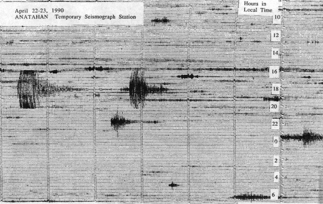
"Seismicity was monitored from the village and periodically from the center of the W bay during the 9-day investigation. From 19 until 25 April, daily seismicity consisted of 3-4 distant earthquakes, possibly aftershocks of the 6 April M 7.5 earthquake in the Mariana Trench (centered at 15.27°N, 147.53°E, 32 km depth). Additionally, 3-4 local events of M 3-4 were recorded each day, usually in pairs (figure 1 and table 2). Only one was felt.
 |
Figure 1. Portion of seismogram from the temporary station on Anatahan, 22-23 April 1990. Courtesy of Robert Koyanagi, USGS. |
Table 2. Earthquakes recorded on Anatahan by the USGS, 19-27 April 1990, using a revolving drum portable seismograph with 1.0 Hz geophone. Magnitude threshold was greater than 0.5 for distances less than 10 km. Events with distances less than 40 km may be volcanically related and located within ~10 km of Anatahan at varying depths beneath the island (the 10 km distance also includes Sarigan Island, N of Anatahan). Seismic recording did not begin until late 19 April. Data courtesy of R. Koyanagi.
| Date | Number | Distance (km) | Magnitude |
| 19 Apr 1990 | 2 | 5 and 30 | 1.7 and 2.2 |
| 20 Apr 1990 | 1 | 35 | 1.3 |
| 21 Apr 1990 | 5 | 10-35 | 0.4-3.2 |
| 22 Apr 1990 | 4 | 25-35 | 0.7-1.8 |
| 23 Apr 1990 | 4 | 25-58 | 2.2-3.5 |
| 24 Apr 1990 | 2 | 30 and 55 | 0.5 and 2.0 |
| 25 Apr 1990 | 2 | 30 and 35 | 1.5 and 4.5 |
| 26 Apr 1990 | 3 | 35-38 | 1.5-2.7 |
| 27 Apr 1990 | 3 | 10 | 0.8-1.0 |
"An EDM network and two radial tilt stations were installed and monitored during the investigation. The tilt stations showed no changes. Because of limited helicopter time, every line of the EDM network was not reoccupied every day, but extensions of 6-91 mm were recorded between measurements on 25 and 26 April."
Geological Summary. The elongate, 9-km-long island of Anatahan in the central Mariana Islands consists of a large stratovolcano with a 2.3 x 5 km compound summit caldera. The larger western portion of the caldera is 2.3 x 3 km wide, and its western rim forms the island's high point. Ponded lava flows overlain by pyroclastic deposits fill the floor of the western caldera, whose SW side is cut by a fresh-looking smaller crater. The 2-km-wide eastern portion of the caldera contained a steep-walled inner crater whose floor prior to the 2003 eruption was only 68 m above sea level. A submarine cone, named NE Anatahan, rises to within 460 m of the sea surface on the NE flank, and numerous other submarine vents are found on the NE-to-SE flanks. Sparseness of vegetation on the most recent lava flows had indicated that they were of Holocene age, but the first historical eruption did not occur until May 2003, when a large explosive eruption took place forming a new crater inside the eastern caldera.
Information Contacts: F. Sasamoto, Office of Civil Defense, Saipan; J. Lockwood, M. Sako, R. Koyanagi, and G. Kojima, HVO; S. Rowland, Univ of Hawaii.

