Report on Langila (Papua New Guinea) — February 1991
Bulletin of the Global Volcanism Network, vol. 16, no. 2 (February 1991)
Managing Editor: Lindsay McClelland.
Langila (Papua New Guinea) Vapor/ash emission and glow
Please cite this report as:
Global Volcanism Program, 1991. Report on Langila (Papua New Guinea) (McClelland, L., ed.). Bulletin of the Global Volcanism Network, 16:2. Smithsonian Institution. https://doi.org/10.5479/si.GVP.BGVN199102-252010
Langila
Papua New Guinea
5.525°S, 148.42°E; summit elev. 1330 m
All times are local (unless otherwise noted)
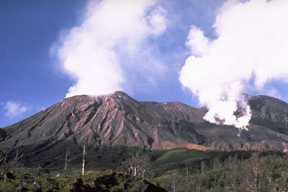
"Activity remained at a low level in February. Crater 2 continued to produce weak-moderate emissions of white to pale grey vapour and ash, and at night a steady weak red glow was observed over the crater. Crater 3 emissions consisted of white vapour released at very low rates. Seismicity was also at a low level. On most days there were no volcanic earthquakes, but between 6 and 16 February up to 4 events/day were recorded."
Geological Summary. Langila, one of the most active volcanoes of New Britain, consists of a group of four small overlapping composite basaltic-andesitic cones on the lower E flank of the extinct Talawe volcano in the Cape Gloucester area of NW New Britain. A rectangular, 2.5-km-long crater is breached widely to the SE; Langila was constructed NE of the breached crater of Talawe. An extensive lava field reaches the coast on the N and NE sides of Langila. Frequent mild-to-moderate explosive eruptions, sometimes accompanied by lava flows, have been recorded since the 19th century from three active craters at the summit. The youngest and smallest crater (no. 3 crater) was formed in 1960 and has a diameter of 150 m.
Information Contacts: C. McKee, RVO.

