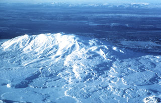
Report on Hekla (Iceland) — March 1991
Bulletin of the Global Volcanism Network, vol. 16, no. 3 (March 1991)
Managing Editor: Lindsay McClelland.
Hekla (Iceland) Lava effusion ends in early March
Please cite this report as:
Global Volcanism Program, 1991. Report on Hekla (Iceland) (McClelland, L., ed.). Bulletin of the Global Volcanism Network, 16:3. Smithsonian Institution. https://doi.org/10.5479/si.GVP.BGVN199103-372070
Hekla
Iceland
63.983°N, 19.666°W; summit elev. 1490 m
All times are local (unless otherwise noted)
"The eruption that started on 17 January (15:12 and 16:1) lasted until 11 March, or nearly 53 days. The eruption produced mainly basaltic andesite lava, with a total area of about 23 km2. Its thickness is as little as 2 m on the steepest slopes of the volcano but exceeds 10 m on flat ground. The estimated average thickness is 6-7 m and the volume of lava is 0.15 km3. The volume of freshly fallen tephra is estimated as roughly 0.02 km3 but negligible when calculated as dense lava. Consequently, 0.15 km3 may be regarded as the total volume produced during this eruption. The lava and tephra are basaltic andesites, almost identical in composition to those produced in the eruptions of 1970 and 1980-81.
"Changes in the volcanic tremor, as well as field observations, indicate that the main eruption occurred from 1700 on 17 January to about 0400 on 18 January. During this period the effusion rate may have attained 2,000 m3/s, but the average production of lava during the first 40 hours of the eruption was ~800 m3/s. After attaining its peak on the first day, the effusion rate decreased rapidly to ~10 m3/s. The rate then decreased slowly during the next three weeks to a temporary minimum of ~1 m3/s on 9 February. The effusion rate increased again on 14 February and was ~10 m3/s on 16 February. The rate decreased to ~3 m3/s on 24 February, to ~1 m3/s on 6 March, and then remained similar until the end of the eruption."
Further Reference. Gudmundsson, A., Oskarsson, N., Grönvold, K., Saemundsson, K., Sigurdsson, O., Stefansson, R., Gislason, S., Einarsson, P., Brandsdottir, B., Larsen, G., Johannesson, H., and Thordarson, T., 1992, The 1991 eruption of Hekla, Iceland: BV, v. 54, p. 238-246.
Geological Summary. One of Iceland's most prominent and active volcanoes, Hekla lies near the southern end of the eastern rift zone. Hekla occupies a rift-transform junction, and has produced basaltic andesites, in contrast to the tholeiitic basalts typical of Icelandic rift zone volcanoes. Vatnafjöll, a 40-km-long, 9-km-wide group of basaltic fissures and crater rows immediately SE of Hekla forms a part of the Hekla-Vatnafjöll volcanic system. A 5.5-km-long fissure, Heklugjá, cuts across the 1491-m-high Hekla volcano and is often active along its full length during major eruptions. Repeated eruptions along this rift, which is oblique to most rifting structures in the eastern volcanic zone, are responsible for Hekla's elongated ENE-WSW profile. Frequent large silicic explosive eruptions during historical time have deposited tephra throughout Iceland, providing valuable time markers used to date eruptions from other Icelandic volcanoes. Hekla tephras are generally rich in fluorine and are consequently very hazardous to grazing animals. Extensive lava flows from historical eruptions, which date back to 1104 CE, cover much of the volcano's flanks.
Information Contacts: A. Gudmundsson, NVI.

