Report on Piton de la Fournaise (France) — July 1991
Bulletin of the Global Volcanism Network, vol. 16, no. 7 (July 1991)
Managing Editor: Lindsay McClelland.
Piton de la Fournaise (France) Brief lava production follows seismicity, deformation, and magnetic changes
Please cite this report as:
Global Volcanism Program, 1991. Report on Piton de la Fournaise (France) (McClelland, L., ed.). Bulletin of the Global Volcanism Network, 16:7. Smithsonian Institution. https://doi.org/10.5479/si.GVP.BGVN199107-233020
Piton de la Fournaise
France
21.244°S, 55.708°E; summit elev. 2632 m
All times are local (unless otherwise noted)
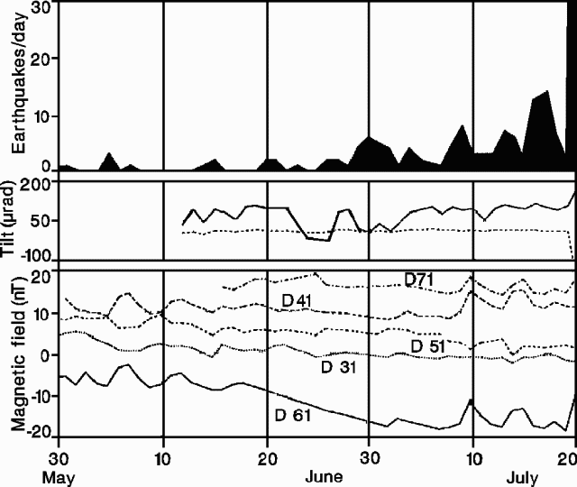
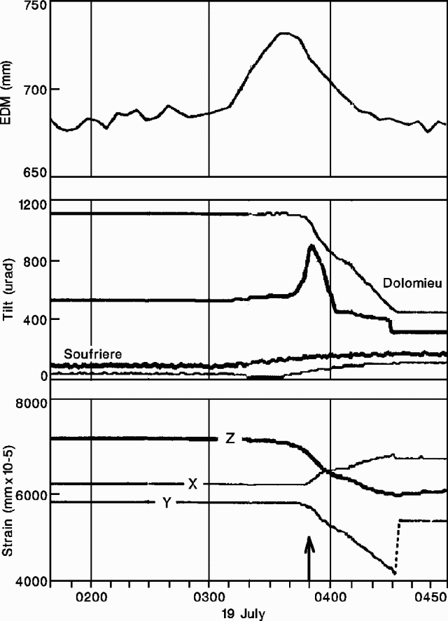
A short eruption occurred on 19-20 July, following a slight increase in seismicity that began 24 June (figure 28), and immediately preceded by a shallow microearthquake swarm. Almost 80 earthquakes (M less than 1.5), located beneath the S flank of the summit cone at depths of less than 1 km, were recorded from 0256 to 0350 on 19 June. At 0350, the appearance of tremor signaled the start of lava outflow.
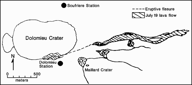
EDM (sampled every 5 minutes) and radial tilt measurements (every minute) at a station (DOLO) ~200 m from the eruptive fissure (figure 29) showed relatively slow inflation beginning at 0310 (figure 30), believed associated with the beginning of intrusion from the magma reservoir. At 0340, radial tilt began to increase rapidly (up to 54 µrad/min), while EDM indicated a rapid decrease in the distance between the rims of the two summit craters. Inflation led to southward tilting (mean azimuth, 175°) of the DOLO station area. Rapid deflation began at 0350, corresponding with the start of tremor, and lasted until 0434. Deflation occurred at maximum rates of 48 µrad/min, causing DOLO to tilt roughly N (azimuth ~10°).
 |
Figure 29. Sketch map showing the summit area of Piton de la Fournaise and the 19 July 1991 lava flows. Courtesy of J-P. Toutain. |
The magnetic field near the eruptive vents (station 6) showed a clear decreasing trend beginning on 16 June (figure 28). On 19 July, a rapid magnetic field increase was measured, corresponding with the onset of the eruption. Lava was emitted from two vents along an eruptive fissure, one inside and one outside of the summit (Dolomieu) crater (figure 29). Lava fountains, 30 m high, were observed during the morning of the 19th and flow velocity was estimated at 3-4 m/s that afternoon. Lava flowed E through the Grandes Pentes area, covering ~1 x 10⁶ m2, with a total volume estimated at 5 x 10⁶ m3. The eruption lasted until about 2000 on 20 July.
Geological Summary. Piton de la Fournaise is a massive basaltic shield volcano on the French island of Réunion in the western Indian Ocean. Much of its more than 530,000-year history overlapped with eruptions of the deeply dissected Piton des Neiges shield volcano to the NW. Three scarps formed at about 250,000, 65,000, and less than 5,000 years ago by progressive eastward slumping, leaving caldera-sized embayments open to the E and SE. Numerous pyroclastic cones are present on the floor of the scarps and their outer flanks. Most recorded eruptions have originated from the summit and flanks of Dolomieu, a 400-m-high lava shield that has grown within the youngest scarp, which is about 9 km wide and about 13 km from the western wall to the ocean on the E side. More than 150 eruptions, most of which have produced fluid basaltic lava flows, have occurred since the 17th century. Only six eruptions, in 1708, 1774, 1776, 1800, 1977, and 1986, have originated from fissures outside the scarps.
Information Contacts: J-P. Toutain and P. Taochy, OVPDLF; P. Bachelery, Univ de la Réunion; J-L. Cheminée, P. Blum, A. Hirn, J. LePine, and J. Zlotnicki, IPGP; F. Garner and I. Appora, Univ Paris VI.


