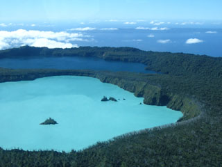
Report on Ambae (Vanuatu) — July 1991
Bulletin of the Global Volcanism Network, vol. 16, no. 7 (July 1991)
Managing Editor: Lindsay McClelland.
Ambae (Vanuatu) Caldera lake bubbling; burned vegetation
Please cite this report as:
Global Volcanism Program, 1991. Report on Ambae (Vanuatu) (McClelland, L., ed.). Bulletin of the Global Volcanism Network, 16:7. Smithsonian Institution. https://doi.org/10.5479/si.GVP.BGVN199107-257030
Ambae
Vanuatu
15.389°S, 167.835°E; summit elev. 1496 m
All times are local (unless otherwise noted)
"Three anomalous 'boiling' areas with large bubbles and burned vegetation were observed at Lake Vui on 13 July, by P. Fogarty (Chief Pilot of VANAIR). This was the first time he had observed such a phenomenon, and he noted that the vegetation had still been green in May. An aerial survey of the two summit calderas was carried out (during a VANAIR flight) on 24 July. At that time, no strong degassing was visible, but 3 areas of discolored water (each several tens of meters in diameter) were noticeable in the crater lake. Burned vegetation was observed up to the crater rim, 120 m above the water. On 26 July, microseismicity in the caldera was very weak and without any volcanic characteristics.
"Although continuous weak solfataric activity occurs beneath Lake Vui (Warden, 1970), an anomalously strong SO2 degassing is believed to have occurred between May and July. This event was unnoticed by island residents, but since Aoba has been quiet for 300 years, vigilance for this kind of phenomenon must be improved. The existence of a summit caldera lake, numerous lahar deposits, and thick layers of ash (vesiculated and accretionary lapilli) demonstrate the hazards that would accompany renewed activity. Thus, as a precaution, a seismological station was installed in July on the SW flank of the volcano.
Reference. Warden, A.J., 1970, Evolution of Aoba caldera volcano, New Hebrides: BV, v. 34, p. 107-140.
Geological Summary. The island of Ambae, also known as Aoba, is a massive 2,500 km3 basaltic shield that is the most voluminous volcano of the New Hebrides archipelago. A pronounced NE-SW-trending rift zone with numerous scoria cones gives the 16 x 38 km island an elongated form. A broad pyroclastic cone containing three crater lakes (Manaro Ngoru, Voui, and Manaro Lakua) is located at the summit within the youngest of at least two nested calderas, the largest of which is 6 km in diameter. That large central edifice is also called Manaro Voui or Lombenben volcano. Post-caldera explosive eruptions formed the summit craters about 360 years ago. A tuff cone was constructed within Lake Voui (or Vui) about 60 years later. The latest known flank eruption, about 300 years ago, destroyed the population of the Nduindui area near the western coast.
Information Contacts: C. Robin and M. Monzier, ORSTOM, Nouméa, New Caledonia; M. Lardy and C. Douglas, ORSTOM, Vanuatu; C. Mortimer, Dept. of Geology, Mines, and Rural Water Supply, Vanuatu; J. Eissen, ORSTOM, France.

