Report on Santa Maria (Guatemala) — November 1991
Bulletin of the Global Volcanism Network, vol. 16, no. 11 (November 1991)
Managing Editor: Lindsay McClelland.
Santa Maria (Guatemala) Explosions and block lava flow; continued lahar-induced changes in S-flank drainages
Please cite this report as:
Global Volcanism Program, 1991. Report on Santa Maria (Guatemala) (McClelland, L., ed.). Bulletin of the Global Volcanism Network, 16:11. Smithsonian Institution. https://doi.org/10.5479/si.GVP.BGVN199111-342030
Santa Maria
Guatemala
14.757°N, 91.552°W; summit elev. 3745 m
All times are local (unless otherwise noted)
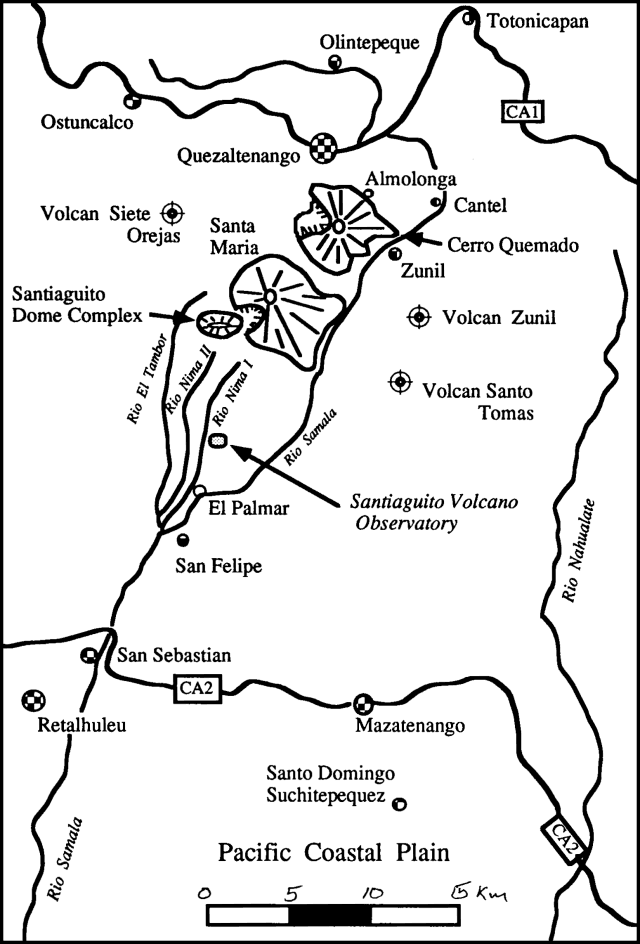
"On 12-14 November geoscientists from INSIVUMEH and Michigan Technological Univ (MTU) spent 3-6 hours/day observing Santiaguito dome. Observation sites included the old Magermann 'Hotel', the Santiaguito Volcano Observatory (figure 21), and a N-S-trending ridge about 1 km E of Caliente vent.
 |
Figure 21. Sketch map showing the are around Santa Maria, including adjacent volcanoes and the Santiaguito Observatory. Courtesy of M. Conway. |
"Activity during this period consisted of phreatic (or phreatomagmatic) and magmatic eruptions. Phreatic eruptions were semi-regular during the morning (one every 15-20 minutes from 0700 to 1100) and tapered off somewhat in the early afternoon to one every 30 or 45 minutes. After about 1400, clouds made observations impossible. Phreatic eruptions originated in the open crater of Caliente vent. They generally lasted 1-3 minutes and consisted of a vertical, white to light-gray plume comprised of gas, finely comminuted non-vesicular dacite glass, and subordinate amounts of fine-grained opaque minerals and plagioclase. Plumes typically rose 1-2 km above the vent where they were quickly beheaded and dispersed to the SW by prevailing winds.
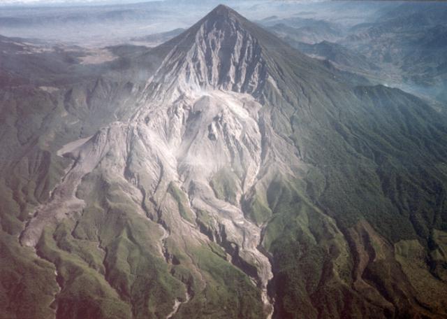
"A block lava flow, active for about 16 months, continued to erupt from Caliente vent (figure 22). The flow had recently reached the headwaters of the Río Nimá I, where it changed direction from E to S. Because of constriction of the lava flow at this junction, its front had stagnated and fresh lava was piling up on the upper E flanks of Caliente. This oversteepened lava cap commonly produced small-volume hot rock avalanches; at night, incandescent avalanches were visible [from San Felipe, 14 km SSE]. As lava continued to pile up around the vent, the potential for a [lava flow] collapse increased. Such an event would likely produce a large block-and-ash flow and accompanying ash-cloud surge. In the past, most notably on 19 July 1989 and 19 July 1991, block-and-ash flows entered the Río Nimá drainages and traveled several kilometers downstream. Accompanying pyroclastic surges detached from the flows and traveled E, blowing down trees, scorching vegetation, and blanketing a several-km2 area E of the dome with ash and lapilli. Collapse of the lava flow cap on Caliente's E rim would probably produce similar effects.
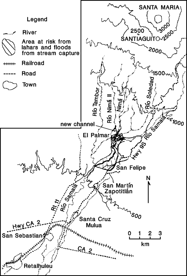
"Lahars originating near Santiaguito continued to present a serious hazard in the Ríos Nimá I and II and the Río Samalá. The bridge over Río Nimá II at El Palmar, destroyed by a lahar in 1990, has since been replaced by a temporary structure. A lahar destroyed the foot bridge over the Río Samalá near San Felipe in July. The same month, a lahar broke through the perched levees of the Río Nimá II and spilled into the Río Nimá I near Finca Santa Marta ("new channel" on figure 23). The lahar temporarily dammed the Río Nimá I, producing a small reservoir 200 m long and nearly 2 m deep. The new channel linking the Ríos Nimá II and I was about 5 m wide and 6 m deep.
 |
Figure 23. Sketch map of rivers and towns S of Santiaguito. Locations of drainages are approximate. Courtesy of Michael Conway. |
"Capture of the Río Nimá II by the Río Nimá I could seriously threaten local communities. In particular, El Palmar, on the E bank of the Río Nimá I, would be endangered by lahars and flood inundation. Furthermore, an increase in the hydraulic load of the Río Nimá I could result in its capture by the Río Samalá at the S end of El Palmar. Such an event would increase the probability of flooding or inundation by lahars downstream in the town of San Felipe. Moreover, a sudden increase in the sediment load of the Río Samalá could lead to temporary damming of the river. This in turn could cause flooding of Finca Las Marías, upstream in the Río Samalá."
Geological Summary. Symmetrical, forest-covered Santa María volcano is part of a chain of large stratovolcanoes that rise above the Pacific coastal plain of Guatemala. The sharp-topped, conical profile is cut on the SW flank by a 1.5-km-wide crater. The oval-shaped crater extends from just below the summit to the lower flank, and was formed during a catastrophic eruption in 1902. The renowned Plinian eruption of 1902 that devastated much of SW Guatemala followed a long repose period after construction of the large basaltic-andesite stratovolcano. The massive dacitic Santiaguito lava-dome complex has been growing at the base of the 1902 crater since 1922. Compound dome growth at Santiaguito has occurred episodically from four vents, with activity progressing E towards the most recent, Caliente. Dome growth has been accompanied by almost continuous minor explosions, with periodic lava extrusion, larger explosions, pyroclastic flows, and lahars.
Information Contacts: Rodolfo Morales and Otoniel Matías, INSIVUMEH; Michael Conway, Michigan Technological Univ.


