Report on Pinatubo (Philippines) — December 1991
Bulletin of the Global Volcanism Network, vol. 16, no. 12 (December 1991)
Managing Editor: Lindsay McClelland.
Pinatubo (Philippines) Steaming continues but seismicity declines; lahar threat persists
Please cite this report as:
Global Volcanism Program, 1991. Report on Pinatubo (Philippines) (McClelland, L., ed.). Bulletin of the Global Volcanism Network, 16:12. Smithsonian Institution. https://doi.org/10.5479/si.GVP.BGVN199112-273083
Pinatubo
Philippines
15.13°N, 120.35°E; summit elev. 1486 m
All times are local (unless otherwise noted)
Seismic activity at Pinatubo has declined notably during the past few months. As of early January, seismicity was characterized by high-frequency earthquakes of small to moderate magnitude, perhaps related to adjustments along local faults or within the caldera area. The number of recorded volcanic earthquakes ranged from 10 to 17/day. The events were seldom felt. A six-station telemetered seismic network will continue to monitor the volcano. Ash emission from the caldera has not been observed for 4 months, and steaming has not intensified. Geologists noted the possibility of future dome growth.
Pinatubo's status was officially reduced to Alert Level 2 on 4 December. A danger zone with a radius of 10 km remains in effect because of the risk of secondary explosions from the still-hot pyroclastic materials. Lahars will continue to threaten low-lying areas susceptible to flooding, particularly those that have previously been affected.
Kelvin Rodolfo notes that several typhoons typically strike central Luzon Island annually, but none have passed near Pinatubo since the moderate storm (Yunya) during the eruption's paroxysmal phase. Yunya's center was only about 100 km ENE of the summit at 1100 on 15 June, causing wind shifts that brought significant ashfall to the area S of the volcano, where normal seasonal wind patterns would not have deposited ash. Beginning at about 0400 and continuing throughout the day, heavy rains associated with the leading edge of the storm triggered lahars, many of the debris-flow type, down all of Pinatubo's major valleys, destroying several bridges.
Rains carried by the NE trade winds were abnormally strong on Pinatubo's E side in June and July, generating frequent lahars on that flank. Lahars were rare on the W flank until the SW monsoonal rains, delayed for about 2 months, began in late July. Although >115 cm of monsoonal rain fell 12-26 August, a major typhoon can produce that much rain in 1-2 days. The 1991 lahars were primarily hyperconcentrated flows, whereas intense typhoon rain is more likely to generate debris flows. Most of the eruption debris remains in place.
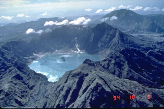
Geological Summary. Prior to 1991 Pinatubo volcano was a relatively unknown, heavily forested lava dome complex located 100 km NW of Manila with no records of historical eruptions. The 1991 eruption, one of the world's largest of the 20th century, ejected massive amounts of tephra and produced voluminous pyroclastic flows, forming a small, 2.5-km-wide summit caldera whose floor is now covered by a lake. Caldera formation lowered the height of the summit by more than 300 m. Although the eruption caused hundreds of fatalities and major damage with severe social and economic impact, successful monitoring efforts greatly reduced the number of fatalities. Widespread lahars that redistributed products of the 1991 eruption have continued to cause severe disruption. Previous major eruptive periods, interrupted by lengthy quiescent periods, have produced pyroclastic flows and lahars that were even more extensive than in 1991.
Information Contacts: PHIVOLCS; Kelvin Rodolfo, Univ of Illinois.

