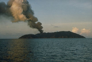
Report on Barren Island (India) — May 1992
Bulletin of the Global Volcanism Network, vol. 17, no. 5 (May 1992)
Managing Editor: Lindsay McClelland.
Barren Island (India) Continued gas emission from central crater and lava flow; animal and plant life recovering
Please cite this report as:
Global Volcanism Program, 1992. Report on Barren Island (India) (McClelland, L., ed.). Bulletin of the Global Volcanism Network, 17:5. Smithsonian Institution. https://doi.org/10.5479/si.GVP.BGVN199205-260010
Barren Island
India
12.278°N, 93.858°E; summit elev. 354 m
All times are local (unless otherwise noted)
A multidisciplinary team from the GSI, IMD, CARI, and the Wildlife Dept visited Barren Island on 21-22 May. Hot gas was emerging from the funnel-shaped [300-m-deep] crater, which had an estimated diameter of [400 m] at the rim. The 1991 lava flow that extended to the coast was covered with rain-compacted scoriae and ash, and had a smooth, flat surface like a paved road. The flow's surface temperature was 40°C, but at 1/3 m depth it exceeded the thermometer's 360°C limit. Gases were emitted from small holes in the flow. A portable seismograph recorded several mild seismic events.
Some burnt ficus trees on the NW coast were sprouting new shoots, but badly charred ones appeared dead. Crabs were plentiful, even on the lava flow, and 25 feral goats were counted in one hour in the surrounding hills. Many birds were visible, but rats were completely absent. The water around the island was clear and of normal temperature, and fish were observed.
Further References. Haldar, D., Laskar, T., Bandyapadhyay, P.C., Sarkar, N.K., and Biswas, J.K., 1992, Volcanic eruption of the Barren Island volcano, Andaman Sea: J. of the Geological Society of India, v. 39, no. 5, p. 411-419.
Haldar, D., Laskar, T., Bandyapadhyay, P.C., Sarkar, N.K., and Biswas, J.K., 1992, A note on the recent eruption of the Barren Island volcano: Indian Minerals, v. 46, no. 1, p. 77-88.
Geological Summary. Barren Island, a possession of India in the Andaman Sea about 135 km NE of Port Blair in the Andaman Islands, is the only historically active volcano along the N-S volcanic arc extending between Sumatra and Burma (Myanmar). It is the emergent summit of a volcano that rises from a depth of about 2250 m. The small, uninhabited 3-km-wide island contains a roughly 2-km-wide caldera with walls 250-350 m high. The caldera, which is open to the sea on the west, was created during a major explosive eruption in the late Pleistocene that produced pyroclastic-flow and -surge deposits. Historical eruptions have changed the morphology of the pyroclastic cone in the center of the caldera, and lava flows that fill much of the caldera floor have reached the sea along the western coast.
Information Contacts: S. Acharya, SANE.

