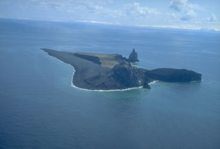
Report on Bogoslof (United States) — June 1992
Bulletin of the Global Volcanism Network, vol. 17, no. 6 (June 1992)
Managing Editor: Lindsay McClelland.
Bogoslof (United States) Steam and ash emission
Please cite this report as:
Global Volcanism Program, 1992. Report on Bogoslof (United States) (McClelland, L., ed.). Bulletin of the Global Volcanism Network, 17:6. Smithsonian Institution. https://doi.org/10.5479/si.GVP.BGVN199206-311300
Bogoslof
United States
53.93°N, 168.03°W; summit elev. 150 m
All times are local (unless otherwise noted)
A eruption . . . had begun by 6 July, when airplane pilots first reported steam and ash rising through low clouds. Similar activity was seen through the week, when satellite images revealed repeated plumes from Bogoslof. Pilots reported a cloud to ~3 km altitude on 14 July at 1815. Satellite images showed the plume extending roughly 100 km SE, to the S side of Unalaska Island. An image from 16 July at 1140 showed another plume extending ~100 km E to Unalaska. That day, a pilot saw a white plume rising to ~4 km altitude. An episode of vigorous steam and ash ejection began on 20 July at about 1700, and material had reached nearly 8 km asl by 1725, drifting NNE. A dark gray cloud that was ~15 km wide at 3 km altitude was moving NW from the volcano several hours later. Poor weather prevented subsequent observations, but satellite images showed no volcanic plumes rising above weather-cloud tops at ~6 km elevation. There have been no reports of ashfall. Cloudy weather has prevented direct observation of the island . . . .
Geological Summary. Bogoslof is the emergent summit of a submarine volcano that lies 40 km N of the main Aleutian arc. It rises 1,500 m above the Bering Sea floor. Repeated construction and destruction of lava domes at different locations during historical time has greatly modified the appearance of this "Jack-in-the-Box" volcano and has introduced a confusing nomenclature applied during frequent visits by exploring expeditions. The present triangular-shaped, 0.75 x 2 km island consists of remnants of lava domes emplaced from 1796 to 1992. Castle Rock (Old Bogoslof) is a steep-sided pinnacle that is a remnant of a spine from the 1796 eruption. The small Fire Island (New Bogoslof), about 600 m NW of Bogoslof Island, is a remnant of a lava dome formed in 1883.
Information Contacts: AVO; SAB.

