Report on Manam (Papua New Guinea) — August 1992
Bulletin of the Global Volcanism Network, vol. 17, no. 8 (August 1992)
Managing Editor: Lindsay McClelland.
Manam (Papua New Guinea) Strong explosions; lava flow; pyroclastic flow reaches the sea
Please cite this report as:
Global Volcanism Program, 1992. Report on Manam (Papua New Guinea) (McClelland, L., ed.). Bulletin of the Global Volcanism Network, 17:8. Smithsonian Institution. https://doi.org/10.5479/si.GVP.BGVN199208-251020
Manam
Papua New Guinea
4.08°S, 145.037°E; summit elev. 1807 m
All times are local (unless otherwise noted)
"Strong eruptive activity resumed at Manam after a 2-month quiet period. Following the March-June eruption, activity in both craters was very subdued, consisting only of weak fumaroles, a faint night glow, and low-level seismicity.
"From 10 August, however, mild, deep-seated eruptive activity resumed in Southern Crater, with weak white and blue vapour emissions, weak roaring sounds, and a fluctuating night glow. Seismicity remained at a moderately low level, but a definite inflation trend was recorded by the water-tube tiltmeter . . . (+2 µrad in three weeks).
"On 21 August, activity increased with forceful degassing and incandescent Strombolian projections over Southern Crater. By 29-30 August, dark ash-laden vapour emissions were released intermittently and nighttime incandescent projections were reaching 700 m above the crater.
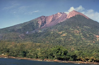
"This activity culminated in a paroxysmal phase on 31 August. The microseismicity increased in intensity from mid-morning. Unfortunately, cloudy weather hampered observations, but starting from 1650, forceful continuous eruption of incandescent material took place and lasted for ~6 hours. A dark column of basaltic pumice and ash rose to ~5,000 m above the summit of the volcano, and produced heavy lapilli/scoriae and ashfall over the WNW side of the island until about 1930. Concurrently, lava emitted by Southern Crater started to flow into the SW valley, cascading down the headwall. At about 1700 a large pyroclastic flow ran down the same valley. At ~600 m asl it overflowed the narrow valley-channel and progressed down to the sea with a width of ~120 m. Another pyroclastic flow ran down the SE valley, along the southern bank, but stopped at ~500 m asl.
"The high level of eruptive activity (with strong red glow observed through the cloud cover) lasted until 2300. The next day, the mountain was still cloud-covered. The level of seismicity and noise had decreased but the lava flow was still active.
"Field inspection on 4-6 September revealed that the pyroclastic-flow deposits in the SW valley were still hot, consisted of scoriae, boulders, and tree trunks, and were 6 m thick at the coast. The flow had devastated vegetation and gardens along the way, but fortunately had not hit two neighbouring coastal villages. The coastal road was cut off. The lava flow had overridden the pyroclastic flow deposits but had stopped at ~700 m asl. The flow front was ~70 m wide and 5 m high. The pyroclastic-flow deposit in the SE valley consisted mainly of scoriae. Southern Crater was breached to the south. Lapilli and ashfall on the W and NW flanks of the volcano had severely damaged subsistence gardens. The largest scoria at Tabele Observatory was 12 cm.
"Interestingly, this paroxysmal phase occurred a couple of days after the radial tilt had reversed, from a rising to a rapidly deflating trend. The tilt has now (early September) lost all the inflation accumulated earlier; seismicity has dropped to a relatively low level, and visible activity in Southern Crater is limited to weak white-grey emissions, intermittent deep explosion sounds and a weak night glow. Main Crater has remained inactive since mid-June."
Geological Summary. The 10-km-wide island of Manam, lying 13 km off the northern coast of mainland Papua New Guinea, is one of the country's most active volcanoes. Four large radial valleys extend from the unvegetated summit of the conical basaltic-andesitic stratovolcano to its lower flanks. These valleys channel lava flows and pyroclastic avalanches that have sometimes reached the coast. Five small satellitic centers are located near the island's shoreline on the northern, southern, and western sides. Two summit craters are present; both are active, although most observed eruptions have originated from the southern crater, concentrating eruptive products during much of the past century into the SE valley. Frequent eruptions, typically of mild-to-moderate scale, have been recorded since 1616. Occasional larger eruptions have produced pyroclastic flows and lava flows that reached flat-lying coastal areas and entered the sea, sometimes impacting populated areas.
Information Contacts: P. de Saint-Ours and C. McKee, RVO.

