Report on Zaozan [Zaosan] (Japan) — September 1992
Bulletin of the Global Volcanism Network, vol. 17, no. 9 (September 1992)
Managing Editor: Lindsay McClelland.
Zaozan [Zaosan] (Japan) Earthquake and numerous aftershocks, but no surface changes evident
Please cite this report as:
Global Volcanism Program, 1992. Report on Zaozan [Zaosan] (Japan) (McClelland, L., ed.). Bulletin of the Global Volcanism Network, 17:9. Smithsonian Institution. https://doi.org/10.5479/si.GVP.BGVN199209-283190
Zaozan [Zaosan]
Japan
38.144°N, 140.44°E; summit elev. 1841 m
All times are local (unless otherwise noted)
A seismic shock of M 4.7 occurred at 1758 on 1 September a few kilometers ESE of the summit. The shock was felt at JMA intensity IV near the volcano, and was weakly felt at Sendai (35 km E), Fukushima (45 km S), and Onahama (135 km E). Aftershocks were numerous, but declined toward mid-September. The high seismicity was the first at the volcano since July 1990, when there were many small earthquakes below the summit. Surveys of fumarolic areas on 5 September revealed no changes in temperature from the last survey in 1990.
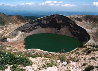
Geological Summary. The Zaozan (or Zaosan) volcano group consists of a complex cluster of stratovolcanoes in north-central Honshu about 40 km W of Sendai Bay. The Pleistocene Ryuzan volcano forms the western group (Nishi-Zao), and Byobu and Fubo volcanoes form the southern group (Minami-Zao). The complex was constructed over granitic basement rocks thus has a relatively small volume. The 7 km3 Zaozan volcano proper forms the central group (Chuo-Zao), a complex topped by several lava domes and the Goshikidake tuff cone, aligned NW-SE. Several episodes of edifice collapse produced debris avalanches during the Pleistocene. Goshikidake contains the active Okama crater, filled with a colorful, strongly acidic crater lake; it has been the source of most of the frequent eruptions recorded since the 8th century CE.
Information Contacts: JMA.

