Report on Arenal (Costa Rica) — August 1993
Bulletin of the Global Volcanism Network, vol. 18, no. 8 (August 1993)
Managing Editor: Edward Venzke.
Arenal (Costa Rica) Large pyroclastic flow down W flank; lava flows
Please cite this report as:
Global Volcanism Program, 1993. Report on Arenal (Costa Rica) (Venzke, E., ed.). Bulletin of the Global Volcanism Network, 18:8. Smithsonian Institution. https://doi.org/10.5479/si.GVP.BGVN199308-345033
Arenal
Costa Rica
10.463°N, 84.703°W; summit elev. 1670 m
All times are local (unless otherwise noted)
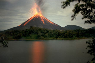
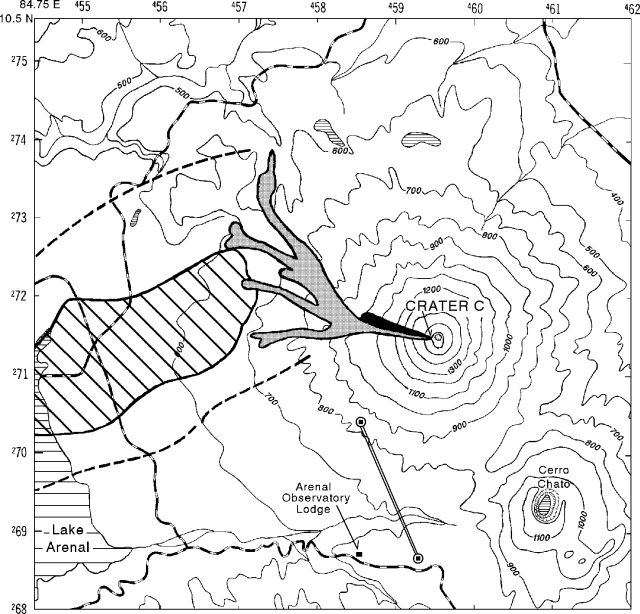
New lava flows in late August were accompanied by one or more pyroclastic flows and a minor ashfall containing accretionary lapilli. On 28 August scientists at OVSICORI reported an active lava flow, followed by multiple pyroclastic flows at 2005-2044. Figure 61 documents the path of the new lava flow, the paths of possible multiple pyroclastic flows, the zone of disrupted vegetation (including many tree limbs broken by the weight of airfall ash), and the outer limits of airfall ash. Earlier in August, repeated lava eruptions, fumarolic activity, and occasional tephra emissions issued from crater C in a pattern well established over the past several years.
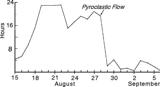
The number of seismic events per month increased from January to April, but dropped to about half the April peak in May, and was roughly constant through August (figure 62, top). Thus, the number of seismic events per month has not been diagnostic of Arenal's recent, more explosive phase. In contrast, the number of hours of tremor/day (figure 62, bottom) clearly increased from May to August; it reached nearly continuous levels (23 hours/day) for 18-22 August, and remained comparatively high until the 28 August eruption (figure 63).
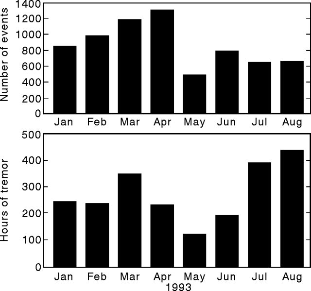 |
Figure 62. Seismicity for 1993 at Arenal showing monthly totals for number of events (top) and hours of tremor (bottom). Courtesy of OVSICORI. |
Dry-tilt measurements made from October 1992 to 21 July 1993 on the W flank of the volcano showed inflation of 15 µrad. Horizontal strain computed from surveyed distance measurements on a SW sub-radial line (figure 61) for 1992-1993 generally indicated weak to moderate contraction. The last reported measurement, 24 August, was atypical because it indicated a length contraction of 116 ± 3 ppm, >4x as large as any reported in the last year.
On 27 August, seismic signals were of intermediate frequency, 6.5 mm amplitude and consistently of 118 seconds duration. Scientists at OVSICORI noted that these characteristic signals were repeated, and were possibly due to a series of small pyroclastic flows thought to have been generated by the partial collapse of active lava flows and a spatter cone constructed by Strombolian activity in the past few years. One or more larger pyroclastic flows were generated the next day (see figure 61).
Scientists at ICE reported that from about 2000-2040 on 28 August, several rockslides issued from the WNW face of the crater C cone; these loosened ~7 x 10⁵ m3 of material and were seismically registered 3.5 km E of the summit at the La Fortuna station (figure 64). At 2030, lava erupted from crater C and flowed NW. Then, from 2102-2105, ash discharged and flowed downslope. The resulting pyroclastic flow divided into multiple lobes. Associated with the pyroclastic flow, an ash cloud rose several kilometers. Deposits from the ash cloud consist of fine ash and accretionary lapilli, the latter presumably caused by mixing of ash with water droplets above the weather-cloud deck (see figure 64). The airfall deposit was distributed to the W of Arenal: 25-40 mm thick at 3 km, 0.5 mm thick at 13.5 km, and detected, but of unspecified thickness, at 30 km. After the ash discharge a blocky lava flow issued from the new crater opening. The lava advanced at an initial rate of 1,000 m/day on the first day, and at ~100 m/day on subsequent days.
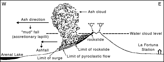 |
Figure 64. Diagrammatic illustration of Arenal's 28 August eruption (not to scale). Courtesy of ICE. |
Although the recent eruption caused no injuries, ashfall led to respiratory problems among some inhabitants of the region.
Geological Summary. Conical Volcán Arenal is the youngest stratovolcano in Costa Rica and one of its most active. The 1670-m-high andesitic volcano towers above the eastern shores of Lake Arenal, which has been enlarged by a hydroelectric project. Arenal lies along a volcanic chain that has migrated to the NW from the late-Pleistocene Los Perdidos lava domes through the Pleistocene-to-Holocene Chato volcano, which contains a 500-m-wide, lake-filled summit crater. The earliest known eruptions of Arenal took place about 7000 years ago, and it was active concurrently with Cerro Chato until the activity of Chato ended about 3500 years ago. Growth of Arenal has been characterized by periodic major explosive eruptions at several-hundred-year intervals and periods of lava effusion that armor the cone. An eruptive period that began with a major explosive eruption in 1968 ended in December 2010; continuous explosive activity accompanied by slow lava effusion and the occasional emission of pyroclastic flows characterized the eruption from vents at the summit and on the upper western flank.
Information Contacts: E. Fernández, J. Barquero, R. Van der Laat, F. de Obaldia, T. Marino, V. Barboza, and R. Sáenz, OVSICORI; G. Soto, ICE.

