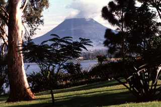
Report on Nyiragongo (DR Congo) — July 1994
Bulletin of the Global Volcanism Network, vol. 19, no. 7 (July 1994)
Managing Editor: Richard Wunderman.
Nyiragongo (DR Congo) Lava lake activity produces strong red glow above crater
Please cite this report as:
Global Volcanism Program, 1994. Report on Nyiragongo (DR Congo) (Wunderman, R., ed.). Bulletin of the Global Volcanism Network, 19:7. Smithsonian Institution. https://doi.org/10.5479/si.GVP.BGVN199407-223030
Nyiragongo
DR Congo
1.52°S, 29.25°E; summit elev. 3470 m
All times are local (unless otherwise noted)
For four days around 14 July a dense steam-and-gas plume was visible from Goma, and red glow could be seen at night. An amateur video taken on an unknown day between 19 and 24 July included a 6-second partial view of the crater that revealed a large very active lava fountain roughly in the center of the crater. A large, flat spatter cone had been built, with a least three large openings in the walls and lava flows radiating from the openings. The entire lava lake was not active. The background was hidden by gases and clouds, making it impossible to determine the elevation of the lava lake surface. Following the 1982 activity, the surface was 400 m below the crater rim. A very strong red glow was again observed above the crater during the night of 29 July. Very little red glow was reported in early August.
Another eruption within the summit lava lake began at about 1900 on 10 August. Red glow above the summit could be seen from Goma during daylight as well as at night. Press reports also stated that "ash and dust" had been emitted from the volcano. The increased activity on 10-13 August and strong red glow visible from the refugee camps caused some concern among the refugees and relief workers.
Volcanologists from Zaire, Japan, France, and the USGS were all present in Goma from 19 to 23 August. The primary purpose of the USGS scientists was to evaluate the hazards posed to the ongoing relief operations in Goma, which contained more than one million Rwandan refugees and the large Zairian population. Specific hazards addressed included the threat of active lava flows to resettlement camps and infrastructure, the threat of volcanic ash to air relief operations, and the threat of CO2 accumulation to refugees in resettlement camps along the Goma-Sake road.
During the flight to Goma on 19 August, USGS volcanologists flew over and around the crater. Although the crater floor was clearly visible, no signs of activity were observed. However, during the pre-dawn hours on 20 August, strong red glow above the main crater could be seen. Early that morning the French Army flew USGS and French volcanologists to the summit. At that time the lava lake was very active, with fountaining of lava up to 40 m above the surface of the crater floor, estimated to be ~450 m below the crater rim. Seismograms from instruments operated by Zairan scientists clearly showed this eruptive activity. The eruption-related seismicity had ended by 22 August, and no additional red glow was noted. No activity was observed during an aerial inspection the next day, but red glow was again seen early on 24 August.
Geological Summary. The Nyiragongo stratovolcano contained a lava lake in its deep summit crater that was active for half a century before draining catastrophically through its outer flanks in 1977. The steep slopes contrast to the low profile of its neighboring shield volcano, Nyamuragira. Benches in the steep-walled, 1.2-km-wide summit crater mark levels of former lava lakes, which have been observed since the late-19th century. Two older stratovolcanoes, Baruta and Shaheru, are partially overlapped by Nyiragongo on the north and south. About 100 cones are located primarily along radial fissures south of Shaheru, east of the summit, and along a NE-SW zone extending as far as Lake Kivu. Many cones are buried by voluminous lava flows that extend long distances down the flanks, which is characterized by the eruption of foiditic rocks. The extremely fluid 1977 lava flows caused many fatalities, as did lava flows that inundated portions of the major city of Goma in January 2002.
Information Contacts: H. Hamaguchi, Tohoku Univ; J. Durieux, GEVA; T. Casadevall and J. Lockwood, USGS; AP.

