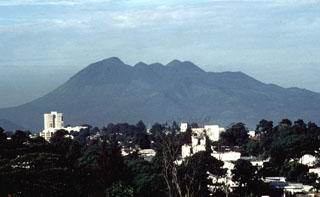
Report on Pacaya (Guatemala) — September 1994
Bulletin of the Global Volcanism Network, vol. 19, no. 9 (September 1994)
Managing Editor: Edward Venzke.
Pacaya (Guatemala) Vigorous Strombolian explosions produce ashfalls and lava flows
Please cite this report as:
Global Volcanism Program, 1994. Report on Pacaya (Guatemala) (Venzke, E., ed.). Bulletin of the Global Volcanism Network, 19:9. Smithsonian Institution. https://doi.org/10.5479/si.GVP.BGVN199409-342110
Pacaya
Guatemala
14.382°N, 90.601°W; summit elev. 2569 m
All times are local (unless otherwise noted)
Activity increased at 0400 on 12 October with vigorous Strombolian explosions. Approximately 5 cm of ash was deposited in El Patrocinio, ~4 km W (figure 12). Ash drifted as far as Santa Lucia Cotzumalguapa, ~45 km WSW on the Pacific lowlands. Although apparently declining on 14 October, Strombolian activity was continuing, an ash plume to 300 m above the vent persisted, and tremor was still being detected by the seismometer at Pacaya. As of 14 October, five lava flows active on MacKenney cone had reached the base of the edifice, two on the N, two on the W, and one on the S flank. Flow velocities were reported to be 10 m/hour. Heavy rains and cloud cover since the start of the increased activity have prevented detailed observations. The Comite Nacional de Emergencias (CONE) evacuated 142 people from the towns of El Patrocinio, El Caracol (3 km SW), and other nearby areas, to San Vincente de Pacaya (5 km NW).
Pacaya is a complex volcano constructed on the S rim of the 14 x 16 km Pleistocene Amatitlan Caldera. In 1565, the first recorded historical eruption from Pacaya caused ashfall for three days in Guatemala City. Following explosions in July and October 1965, Strombolian activity was generally continuous until March 1989 when explosive activity removed ~75 m of the MacKenney cone summit and enlarged the crater. Strombolian activity began again in January 1990 and has continued intermittently since then. This latest episode of activity, although smaller in terms of area impacted by tephra, is similar to the activity during July-August 1991, which again destroyed part of the cone and damaged towns W of the volcano.
Geological Summary. Eruptions from Pacaya are frequently visible from Guatemala City, the nation's capital. This complex basaltic volcano was constructed just outside the southern topographic rim of the 14 x 16 km Pleistocene Amatitlán caldera. A cluster of dacitic lava domes occupies the southern caldera floor. The post-caldera Pacaya massif includes the older Pacaya Viejo and Cerro Grande stratovolcanoes and the currently active Mackenney stratovolcano. Collapse of Pacaya Viejo between 600 and 1,500 years ago produced a debris-avalanche deposit that extends 25 km onto the Pacific coastal plain and left an arcuate scarp inside which the modern Pacaya volcano (Mackenney cone) grew. The NW-flank Cerro Chino crater was last active in the 19th century. During the past several decades, activity has consisted of frequent Strombolian eruptions with intermittent lava flow extrusion that has partially filled in the caldera moat and covered the flanks of Mackenney cone, punctuated by occasional larger explosive eruptions that partially destroy the summit.
Information Contacts: Eddy Sanchez, INSIVUMEH.

