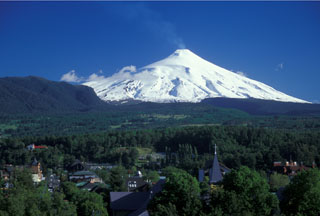
Report on Villarrica (Chile) — December 1994
Bulletin of the Global Volcanism Network, vol. 19, no. 12 (December 1994)
Managing Editor: Richard Wunderman.
Villarrica (Chile) Gas discharges and one thin ashfall in late December
Please cite this report as:
Global Volcanism Program, 1994. Report on Villarrica (Chile) (Wunderman, R., ed.). Bulletin of the Global Volcanism Network, 19:12. Smithsonian Institution. https://doi.org/10.5479/si.GVP.BGVN199412-357120
Villarrica
Chile
39.42°S, 71.93°W; summit elev. 2847 m
All times are local (unless otherwise noted)
Between 25 and 30 December the volcano discharged continuously. At 1000 on 25 December 1994 personnel of Villarrica National Park saw "a small scroll of dark vapor." The plume was estimated as <250 m tall and prevailing winds carried it toward the SE.
The next day at 0815 park rangers noticed a second plume, dark brown to black in color ultimately rising to about 600 m above the summit. Winds again carried this plume SE.
Informants reported that on 29 December they could detect a thin layer of gray ash discoloring all of the snow-covered SE sector of the volcano. They also saw a dark gray stain trending N 120° E reaching at least 6 km (to the Portezuelo Chinay area). That same day, Villarrica discharged gas at 20-30 second intervals that looked grayish to sky blue, apparently rich in SO2. Occasionally light gray to brown drab discharges were also noticed and tentatively interpreted as minor gaseous explosions with a fine-grained ash component.
On 30 December at 0800 and 1100, the volcano produced dense plumes of dark gray to dark brown color. These reached up to 250 m above the crater where they were carried to the SE. After noon a weather front crossed the region and the escaping gases condensed as a great mass and slid down the SE flank. No discharges were specifically reported after this event.
Seismic monitoring began at 1807 on 26 December using a portable MEQ-800 seismograph installed 13.5 km from the principal crater.
During the next few days, tremor was seen; it typically had an amplitude of 2 mm and fundamental frequencies 0.8 Hz. During the first 4 hours of operation, 20-30 second intervals of tremor occurred ~60 times/hour. The next day (27 December) tremor increased to 120 times/hour. Starting at 1700 on 28 December tremor increased still further and it reached higher frequency, up to 1.1 Hz. On 29 and 30 December tremor remained essentially constant in terms of amplitude and duration, but after 0100 on 31 December, intervals of tremor took place more often, an average of 200 times/hour (i.e. 200 distinct intervals of tremor an hour). The number of tremor intervals an hour remained constant until 2100 (31 December) when tremor dropped to the levels seen on 29 and 30 December.
The tremor on 26 and 30 December was similar to that seen routinely during times of repose. Nevertheless, some lower frequency events (~2 Hz) took place coincident with weak ash eruptions. As of 31 December 1994 no new activity was reported.
Geological Summary. The glacier-covered Villarrica stratovolcano, in the northern Lakes District of central Chile, is ~15 km south of the city of Pucon. A 2-km-wide caldera that formed about 3,500 years ago is located at the base of the presently active, dominantly basaltic to basaltic-andesite cone at the NW margin of a 6-km-wide Pleistocene caldera. More than 30 scoria cones and fissure vents are present on the flanks. Plinian eruptions and pyroclastic flows that have extended up to 20 km from the volcano were produced during the Holocene. Lava flows up to 18 km long have issued from summit and flank vents. Eruptions documented since 1558 CE have consisted largely of mild-to-moderate explosive activity with occasional lava effusion. Glaciers cover 40 km2 of the volcano, and lahars have damaged towns on its flanks.
Information Contacts: H. Moreno, G. Fuentealba, M. Petit-Breuilh, and P. Peña, SERNAGEOMIN, Temuco.

