Report on Ubinas (Peru) — July 1996
Bulletin of the Global Volcanism Network, vol. 21, no. 7 (July 1996)
Managing Editor: Richard Wunderman.
Ubinas (Peru) Increased fumarolic activity prompts seismic and other monitoring
Please cite this report as:
Global Volcanism Program, 1996. Report on Ubinas (Peru) (Wunderman, R., ed.). Bulletin of the Global Volcanism Network, 21:7. Smithsonian Institution. https://doi.org/10.5479/si.GVP.BGVN199607-354020
Ubinas
Peru
16.345°S, 70.8972°W; summit elev. 5608 m
All times are local (unless otherwise noted)
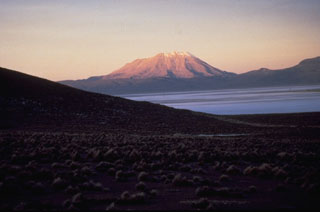
Ubinas stratovolcano (figure 1) is known for persistent weak fumarolic activity; this appeared to increase after December 1995 and was vigorous during April 1996. During April five steam vents were located along a ~N40°W-trending fault cutting across the crater's floor and walls. White steam from the fumaroles commonly rose 100-500 m above the crater and occasionally rose 1-1.5 km above the caldera rim. Seismic monitoring during April detected ~50-70 events/day, a suggestion of increased seismicity.
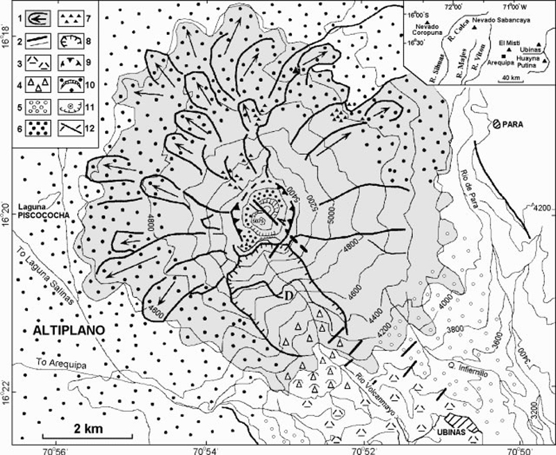
These observations led to designation of the hazard level as "Yellow," and this information was sent to local civil authorities. Scientists installed seismic instruments (three digital PDR-1 Kinemetrics and one visual MEQ-600) on the volcano's W, N, and SE flanks at ~4,800 m elevation.
Continued field work was aimed at assessing hazards and outlining preliminary hazard-zone maps. Potential hazards include debris avalanches, Plinian tephra, phreatic outbursts, and pyroclastic flows and lahars. Debris-avalanche deposits crop out in the Rio Ubinas as far as 10 km downstream. Future debris avalanches could occur if the caldera headwall, which is only 120-400 m thick, failed due to dome extrusion or seismic loading.
Widespread Plinian pumice-fall deposits include some of Holocene age. The eruption that formed the summit caldera left a conspicuous 3-m-thick Plinian tephra chiefly distributed towards the SSE, in the direction of the village of Ubinas (6 km from the vent). At least three Ubinas tephra-fall layers postdate the 1600 AD eruption of Huaynaputina (a center located 25 km S, figure 1). In contrast to the Plinian fall deposits, the intra-caldera deposits are nearly all ash and lapilli fallout of phreatomagmatic and phreatic origin.
Snowfields on the S-facing summit area above 5,000 m elevation remain during December through July and thus could be melted to generate S- and SE-flank debris flows. Pyroclastic flows could follow the same routes. Recent scoria-flow deposits remaining on the steep NW and N flanks suggest that pyroclastic flows may spill over the lower breaches of the caldera rim and down these slopes.
A 27 June news report in the Lima paper El Comercio briefly mentioned ongoing deformation and seismic studies; it included a panoramic view of the summit's nested craters with the inner pit crater emitting steam. The article also pointed out that the district of Ubinas has ~5,000 inhabitants.
Ubinas (also known as Uvinas and Uvillas) is Perú's most active volcano. Holocene lava flows cover its flanks, but the historical record, which extends back to the mid-1500's, contains evidence of minor explosive eruptions. Ubinas rises about 1,300 m above the altiplano of the Cordillera Occidental. Its summit crater is 200-400 m deep, ~1.5 km in diameter, and hosts a smaller inner crater.
Geological Summary. The truncated appearance of Ubinas, Perú's most active volcano, is a result of a 1.4-km-wide crater at the summit. It is the northernmost of three young volcanoes located along a regional structural lineament about 50 km behind the main volcanic front. The growth and destruction of Ubinas I was followed by construction of Ubinas II beginning in the mid-Pleistocene. The upper slopes of the andesitic-to-rhyolitic Ubinas II stratovolcano are composed primarily of andesitic and trachyandesitic lava flows and steepen to nearly 45°. The steep-walled, 150-m-deep summit crater contains an ash cone with a 500-m-wide funnel-shaped vent that is 200 m deep. Debris-avalanche deposits from the collapse of the SE flank about 3,700 years ago extend 10 km from the volcano. Widespread Plinian pumice-fall deposits include one from about 1,000 years ago. Holocene lava flows are visible on the flanks, but activity documented since the 16th century has consisted of intermittent minor-to-moderate explosive eruptions.
Information Contacts: J-C. Thouret and J-L. Le Pennec, ORSTOM (UR14)-Instituto Geofísico del Perú (IGP), Calle Calatrava 216, Urbinizacion Camino Real, La Molina, Lima 100, Perú; R. Woodman, IGP Lima, and O. Macedo, IGP Volcano and Geophysics Observatory, Cayma-Arequipa, Perú.


