Report on Irazu (Costa Rica) — August 1996
Bulletin of the Global Volcanism Network, vol. 21, no. 8 (August 1996)
Managing Editor: Richard Wunderman.
Irazu (Costa Rica) Earthquakes and deformation low to nearly absent
Please cite this report as:
Global Volcanism Program, 1996. Report on Irazu (Costa Rica) (Wunderman, R., ed.). Bulletin of the Global Volcanism Network, 21:8. Smithsonian Institution. https://doi.org/10.5479/si.GVP.BGVN199608-345060
Irazu
Costa Rica
9.979°N, 83.852°W; summit elev. 3436 m
All times are local (unless otherwise noted)
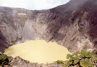
When visited in July the lake filled the crater with greenish yellow water. Constant bubbling issued from many parts of the lake (N, NW, W, SW, and SE sides) and landslides continued to occur down the E, N, and W crater walls. The area on the NW flank where the phreatic eruption had taken place in December 1994 remained fumarolically active.
During the months of June, July, and August the Irazú seismic station registered 48, 33, and 13 local earthquakes, respectively. Survey of the deformation network failed to detect any significant changes since 1994. During February through most of August, dry-tilt at three stations near the summit changed little if any.
Geological Summary. The massive Irazú volcano in Costa Rica, immediately E of the capital city of San José, covers an area of 500 km2 and is vegetated to within a few hundred meters of its broad summit crater complex. At least 10 satellitic cones are located on its S flank. No lava effusion is known since the eruption of the Cervantes lava flows from S-flank vents about 14,000 years ago, and all known Holocene eruptions have been explosive. The focus of eruptions at the summit crater complex has migrated to the W towards the main crater, which contains a small lake. The first well-documented eruption occurred in 1723, and frequent explosive eruptions have occurred since. Ashfall from the last major eruption during 1963-65 caused significant disruption to San José and surrounding areas. Phreatic activity reported in 1994 may have been a landslide event from the fumarolic area on the NW summit (Fallas et al., 2018).
Information Contacts: E. Fernández, E. Duarte, V. Barboza, R. Van der Laat, E. Hernandez, M. Martinez, and R. Sáenz, Observatorio Vulcanológico y Sismológico de Costa Rica, Universidad Nacional (OVSICORI-UNA), Apartado 86-3000, Heredia, Costa Rica.

