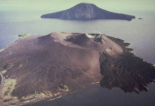
Report on Krakatau (Indonesia) — May 2000
Bulletin of the Global Volcanism Network, vol. 25, no. 5 (May 2000)
Managing Editor: Richard Wunderman.
Krakatau (Indonesia) Elevated May-June seismicity associated with small ash plumes
Please cite this report as:
Global Volcanism Program, 2000. Report on Krakatau (Indonesia) (Wunderman, R., ed.). Bulletin of the Global Volcanism Network, 25:5. Smithsonian Institution. https://doi.org/10.5479/si.GVP.BGVN200005-262000
Krakatau
Indonesia
6.1009°S, 105.4233°E; summit elev. 285 m
All times are local (unless otherwise noted)
This report covers the period of 29 May-26 June 2000. Krakatau volcano was last reported on in BGVN 24:08 (August 1999) and had remained at a stable level of activity up until 0600 on 29 May, a time when seismometers began registering ~150 earthquakes attributed to the beginning of an eruption. Cloud cover made visual inspection impossible on 29 May but inspection on 30 May revealed a dark gray ash plume rising 500 m into the air. Further seismic data from 30 May registered an increase in the number of both deep and shallow volcanic earthquakes; eruption and emission earthquakes increased to ~330 events daily before dropping back down to ~200 events on 31 May. During 3-5 June seismicity remained elevated. A white plume reached ~20 m on 3 June, a very dark plume rose to ~50-500 m on 4 June, and a gray plume ascended to ~50-300 m on June 5. Bad weather inhibited visual observation throughout the rest of the reporting period.
Three booming explosions on 17 June coincided with a decrease in the number of volcanic earthquakes, as well as a marked increase in small explosion earthquakes. Seismic data for the week of 20-26 June contained several large and small explosion earthquakes; a thick gray ash plume was emitted on 25 June, rising to ~250 m. Krakatau remained at alert level 2 (on a scale of 4).
Geological Summary. The renowned Krakatau (frequently mis-named as Krakatoa) volcano lies in the Sunda Strait between Java and Sumatra. Collapse of an older edifice, perhaps in 416 or 535 CE, formed a 7-km-wide caldera. Remnants of that volcano are preserved in Verlaten and Lang Islands; subsequently the Rakata, Danan, and Perbuwatan cones were formed, coalescing to create the pre-1883 Krakatau Island. Caldera collapse during the catastrophic 1883 eruption destroyed Danan and Perbuwatan, and left only a remnant of Rakata. This eruption caused more than 36,000 fatalities, most as a result of tsunamis that swept the adjacent coastlines of Sumatra and Java. Pyroclastic surges traveled 40 km across the Sunda Strait and reached the Sumatra coast. After a quiescence of less than a half century, the post-collapse cone of Anak Krakatau (Child of Krakatau) was constructed within the 1883 caldera at a point between the former Danan and Perbuwatan cones. Anak Krakatau has been the site of frequent eruptions since 1927.
Information Contacts: Volcanological Survey of Indonesia (VSI), Jalan Diponegoro No. 57, Bandung 40122, Indonesia (URL: http://www.vsi.esdm.go.id/).

