Report on Cerro Negro (Nicaragua) — May 2000
Bulletin of the Global Volcanism Network, vol. 25, no. 5 (May 2000)
Managing Editor: Richard Wunderman.
Cerro Negro (Nicaragua) GOES satellite thermal imagery heralded August 1999 eruption
Please cite this report as:
Global Volcanism Program, 2000. Report on Cerro Negro (Nicaragua) (Wunderman, R., ed.). Bulletin of the Global Volcanism Network, 25:5. Smithsonian Institution. https://doi.org/10.5479/si.GVP.BGVN200005-344070
Cerro Negro
Nicaragua
12.506°N, 86.702°W; summit elev. 728 m
All times are local (unless otherwise noted)
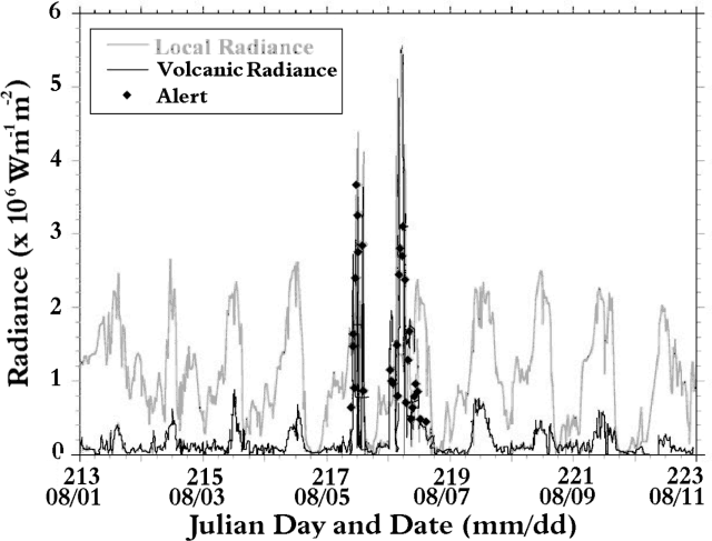
Renewed effusive activity at Cerro Negro during August 1999 (BGVN 24:11) was heralded by a thermal anomaly in GOES thermal (3.9 mm wavelength) data. These data are processed and displayed in real-time at http://hotspot.higp.hawaii.edu/ to monitor selected hot spots associated with volcanic activity across North, Central, and South America, the Pacific, and the Caribbean. Areas of local focus, or "alert boxes," currently include Cerro Negro, Masaya, and Momotombo. The onset of activity at Cerro Negro triggered an automated threshold-based email alert at 0956 local time on 5 August and was evident from a marked increase in volcanic radiance at that time (figure 14). Volcanic radiance is the residual radiance of the volcano after radiance from the ambient background has been subtracted. This calculation is therefore negative in circumstances of low or no activity and positive when the volcano is sufficiently active to exceed the background ambient radiance.
For Cerro Negro, the absence of a thermal anomaly in the GOES data acquired at 0926 coupled with a strong, persistent anomaly from 0956 onwards (figure 14), suggests that effusive activity began at the time 0941 ± 15. Plumes up to 8 km wide and extending 4-19 km to the W and NW were observed on all GOES images acquired between 0956 and 1145 at which point cloud cover obscured Cerro Negro. On the next cloud-free image (1345) and all subsequent images, hot spots only (with no plumes) were observed. Hot spot intensity reached a peak at 0527 on 6 August, before abruptly declining between 0627 and 1356. The absence of a later hot spot suggested that effusion had ended by 1500 on 6 August, having lasted ~28 hours (figure 14). The apparent hiatus between 5 and 6 August was due to cloud cover obscuring the hot spot from the satellite view.
Analysis of these data resulted in the following interpretations. Detection of plumes in the initial stages of eruption correlates with ground reports of ash fall and probably relates to the vents opening. The absence of a later plume suggested fire fountaining with little fine fragmentation. Such activity was also characteristic of the November 1995 eruption (http://tabitha.open.ac.uk/Others/world/vries/cerro_negro/slides.html), and of the 1968 eruption at the Cristo Rey satellitic vent (Viramonte and Di Scala, 1969). The steady hot spot intensity increase followed by a rapid decrease is a pattern similar to observed activity and reported RSAM during the 1995 eruption. The duration of the 1995 eruption was, however, much longer. The siting of the recent vents to the SE may be influenced by the large volume of lava emplaced on the opposite flank during the 1995 eruption. In a similar case, the 1968 eruption, loading of the previously erupted lavas may have influenced both breakout locations.
References. Harris, A.J.L., and Thornber, C., 1999, Complex effusive events at Kīlauea as documented by the GOES satellite and remote video cameras; Bull. Volc., 61(6), 382-395.
Viramonte J.G., and Di Scala, L., 1969, Summary of the 1968 eruption of Cerro Negro, Nicaragua: Bull. Volc., v. 34, p. 346-351.
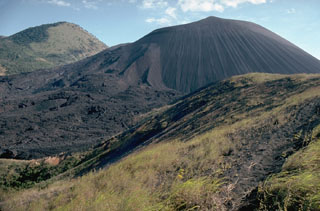
Geological Summary. Nicaragua's youngest volcano, Cerro Negro, was created following an eruption that began in April 1850 about 2 km NW of the summit of Las Pilas volcano. It is the largest, southernmost, and most recent of a group of four youthful cinder cones constructed along a NNW-SSE-trending line in the central Marrabios Range. Strombolian-to-subplinian eruptions at intervals of a few years to several decades have constructed a roughly 250-m-high basaltic cone and an associated lava field constrained by topography to extend primarily NE and SW. Cone and crater morphology have varied significantly during its short eruptive history. Although it lies in a relatively unpopulated area, occasional heavy ashfalls have damaged crops and buildings.
Information Contacts: Andy Harris, Luke Flynn, and Eric Pilger, HIGP/SOEST, University of Hawai'i, 2525 Correa Road, Honolulu, HI 96822 USA (URL: http://modis.higp.hawaii.edu/); Benjamin van Wyk de Vries, Magmas et Volcans, UPB, Clermont-Ferrand, France.


