Report on Villarrica (Chile) — October 2000
Bulletin of the Global Volcanism Network, vol. 25, no. 10 (October 2000)
Managing Editor: Richard Wunderman.
Villarrica (Chile) During 2000 a still-active lava lake, occasional outbursts, and increased lahar risks
Please cite this report as:
Global Volcanism Program, 2000. Report on Villarrica (Chile) (Wunderman, R., ed.). Bulletin of the Global Volcanism Network, 25:10. Smithsonian Institution. https://doi.org/10.5479/si.GVP.BGVN200010-357120
Villarrica
Chile
39.42°S, 71.93°W; summit elev. 2847 m
All times are local (unless otherwise noted)
This report reviews activity during January-May 2000 and September-October 2000. Observations from January through May 2000 were provided by the Proyecto de Observacion Villarrica (POVI). Information about increased seismicity in September and explosions in October were provided by the Observatorio Volcanologico de Los Andes del Sur (OVDAS). Reports for the period June-August 2000 were not available.
Activity during January-May 2000. In January activity was at normal levels. Explosive energy of gas bubbles and incandescence from the lava lake decreased with respect to late 1999. Strombolian activity was observed on 20 January. During February incandescence could be observed on 14 clear nights, indicating weak magmatic activity. Stronger glow was observed on the nights of 19-20 February.
During 1400-1500 on 1 March a series of phreatic events was marked by gas-and-ash emissions. Magmatic activity within the crater decreased with respect to February to more typical levels, causing less incandescence. Activity continued to diminish in April and illumination at the summit also decreased. Incandescence at Villarrica's summit ceased during 5-29 May for the first time since 21 August 1999. At 1430 on 30 May, however, gas-and-ash emissions were observed. Overall, the level of activity was average.
Activity during September-October 2000. As of 20 September, an increase in seismicity occurred at stations VNVI and CVVI while gas and steam emissions ceased, and the usually persistent fumarole disappeared. During 25-28 September, seismic stations VNVI, 4 km from the crater, and CVVI, 19 km from the volcano, recorded anomalous seismicity characterized by clusters of low-frequency earthquakes, harmonic tremor, and tremor bands (periods of tremor separated by seismic silence).
OVDAS raised the hazard status to Green Level 2 on 3 October, indicating that the zone near the crater was dangerous. A flyover of the summit was performed on 4 October to observe any changes in activity. Fumarolic emissions remained absent, and the crater floor was obstructed by black rock. The crater bottom and walls were covered with patches of snow, indicating relatively low temperature. OVDAS prohibited ascents to the top of the volcano because of possible explosions or eruptions. Seismicity that day again showed tremor bands.
On 5 October, an observer of the Centro Volcanológico Villarrica (CVV) reported a short ash eruption with ashfall S towards Coñaripe. At the same time, researchers at the University of Hawaii detected a thermal increase at the summit crater by analysis of GOES 8/10 satellite imagery. Snow fell at the summit on the night of 5 October. An overflight on 6 October revealed a tenuous ash deposit under the recent snow. A small vent opened in the crater, and was subsequently closed by fresh lava. Seismicity included harmonic tremor.
Even a small explosion or eruption would be dangerous because of the potential dislodgement and melting of rock, ice, and snow capping the summit, which could generate a debris flow. Critical locations where lahar risk was highest were determined on the morning of 7 October to prepare for a possible eruption. Crews worked to clear and deepen river channels on or near Villarrica to help reduce damage from a potential lahar. A parapet was also constructed to protect the city and airport of Pucón from debris, ash, or lava flows. Seismicity in the morning showed harmonic tremor, while in the afternoon tremor bands were recorded.
At 1745 on 8 October, a traveler to Coñaripe observed black material rising rhythmically to ~30-50 m above the crater rim and falling back inside. At 1810 there was a small 45-minute-long ash eruption, and wind carried the ash SE. Seismographs indicated harmonic tremor at base levels and at 1400 on 9 October, tremor bands were recorded. An aerial view of the summit on 15 October showed a solid and fractured lava crust on the bottom of the crater and very low gas emission that was mainly water vapor caused by the melting and evaporation of small blocks of ice and snow that fell into the crater. Seismicity remained at a low level as of 15 October.
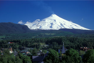
Geological Summary. The glacier-covered Villarrica stratovolcano, in the northern Lakes District of central Chile, is ~15 km south of the city of Pucon. A 2-km-wide caldera that formed about 3,500 years ago is located at the base of the presently active, dominantly basaltic to basaltic-andesite cone at the NW margin of a 6-km-wide Pleistocene caldera. More than 30 scoria cones and fissure vents are present on the flanks. Plinian eruptions and pyroclastic flows that have extended up to 20 km from the volcano were produced during the Holocene. Lava flows up to 18 km long have issued from summit and flank vents. Eruptions documented since 1558 CE have consisted largely of mild-to-moderate explosive activity with occasional lava effusion. Glaciers cover 40 km2 of the volcano, and lahars have damaged towns on its flanks.
Information Contacts: Hugo Moreno, Observatorio Volcanologico de Los Andes del Sur (OVDAS), Casilla 23D, Temuco, Chile (URL: http://www.sernageomin.cl/); Werner Keller U., Proyecto de Observacion Villarrica (POVI), Wiesenstrasse 8, 86438 Kissing, Germany (URL: https://www.povi.cl/).

