Report on Pacaya (Guatemala) — April 2001
Bulletin of the Global Volcanism Network, vol. 26, no. 4 (April 2001)
Managing Editor: Richard Wunderman.
Pacaya (Guatemala) Substantial increases in SO2 degassing
Please cite this report as:
Global Volcanism Program, 2001. Report on Pacaya (Guatemala) (Wunderman, R., ed.). Bulletin of the Global Volcanism Network, 26:4. Smithsonian Institution. https://doi.org/10.5479/si.GVP.BGVN200104-342110
Pacaya
Guatemala
14.382°N, 90.601°W; summit elev. 2569 m
All times are local (unless otherwise noted)
Activity at Pacaya was at a low level during 21-23 January 2001 based on field observations. Activity was characterized by persistent degassing only from a vent on the floor of the MacKenney cone crater. During the afternoon of 22 January, a low-resonance rumbling was noted within 100 m of the crater rim and continuous tremor was felt at the crater rim. Such activity had not been apparent during the previous afternoon.
On 22 February, according to a report from INSIVUMEH, a local seismometer recorded >600 tremors/day, up from <100 tremors/day in earlier weeks. At the same time, gaseous emission had increased from ~253 metric tons/day (equivalent to the SI unit megagrams per day, Mg/d) to ~550 metric tons/day and there was visible magma in the crater.
The SO2 flux was measured by COSPEC along the highway from Guatemala to Escuintla on 1, 15, and 28 February and on 8 March. The respective flux values in metric tons/day were 951, 1,740, 1,448, and 1,673. These flux rates suggested that although lava outpouring was almost nonexistent, degassing of SO2 was quite high. The average gas emission rate for the 20-year period of 1973-93 at Pacaya was estimated by Andres and others (1993) to be 260 metric tons/day.
Reference. Andres, R.J., Rose, W.I., Stoiber, R.E., Williams, S.N., Matías, O., Morales, R., 1993, A summary of sulfur dioxide emission rate measurements from Guatemalan volcanoes: Bull. Volc. 55, p. 379-388.
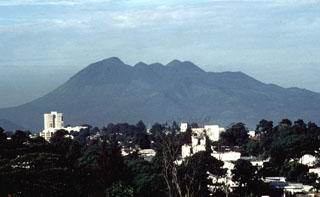
Geological Summary. Eruptions from Pacaya are frequently visible from Guatemala City, the nation's capital. This complex basaltic volcano was constructed just outside the southern topographic rim of the 14 x 16 km Pleistocene Amatitlán caldera. A cluster of dacitic lava domes occupies the southern caldera floor. The post-caldera Pacaya massif includes the older Pacaya Viejo and Cerro Grande stratovolcanoes and the currently active Mackenney stratovolcano. Collapse of Pacaya Viejo between 600 and 1,500 years ago produced a debris-avalanche deposit that extends 25 km onto the Pacific coastal plain and left an arcuate scarp inside which the modern Pacaya volcano (Mackenney cone) grew. The NW-flank Cerro Chino crater was last active in the 19th century. During the past several decades, activity has consisted of frequent Strombolian eruptions with intermittent lava flow extrusion that has partially filled in the caldera moat and covered the flanks of Mackenney cone, punctuated by occasional larger explosive eruptions that partially destroy the summit.
Information Contacts: Andy Harris and Luke Flynn, HIGP/SOEST, University of Hawai'i, 2525 Correa Road, Honolulu, HI 96822, USA (URL: http://modis.higp.hawaii.edu/); Mark Davies, School of Environmental Sciences, University of East Anglia, Norwich, NR4 7TJ, United Kingdom; Bill Rose, Gregg Bluth, and Jeremy Shannon, Department of Geological Engineering and Sciences, Michigan Technological University, Houghton, MI 49931, USA; Otoniel Matías and Gustavo Chigna, INSIVUMEH, 7a Av. 14-57, Zona 13, Guatemala City, Guatemala; Rafael W. Rodriguez, Regional Program Manager, U.S. Geological Survey, Hurricane Mitch Relief Program.

