Report on Galeras (Colombia) — May 2001
Bulletin of the Global Volcanism Network, vol. 26, no. 5 (May 2001)
Managing Editor: Richard Wunderman.
Galeras (Colombia) Low-level seismicity and eruptive activity during April 2000-March 2001
Please cite this report as:
Global Volcanism Program, 2001. Report on Galeras (Colombia) (Wunderman, R., ed.). Bulletin of the Global Volcanism Network, 26:5. Smithsonian Institution. https://doi.org/10.5479/si.GVP.BGVN200105-351080
Galeras
Colombia
1.22°N, 77.37°W; summit elev. 4276 m
All times are local (unless otherwise noted)
According to reports by the Observatorio Vulcanológico y Sismológico de Pasto (OVSP), volcanic unrest at Galeras continued during 16 April 2000-March 2001. However, OVSP reports for November-December 2000 were not available when this report went to press.
Two small eruptive episodes occurred on 22 April and 18 May 2000. The associated seismic records included long-period (LP) events and spasmodic tremor similar to those registered during eruptive episodes on 21 March and 5 April 2000 (BGVN 25:03). Elevated seismicity continued with two volcano-tectonic (VT) events on 30 July and 17 September 2001. These events were focused ENE of the active cone; previous activity initiating within this source region was sporadic. During January-March 2001 activity continued at low levels. VT events occurred during mid- to late-January, and were followed by similar events during late March.
New crater formation during April 2000. Spasmodic tremor starting on 22 April at 1558 lasted for 175 seconds, followed by three smaller tremor episodes with durations of 90, 320, and 170 seconds, respectively. Five small LP events also occurred; the final LP event was recorded at 1634. Peak frequency for the main event was ~5.0 Hz (figure 91), but at the nearest station to the active crater other frequencies ranging from 1 to 13 Hz were observed.
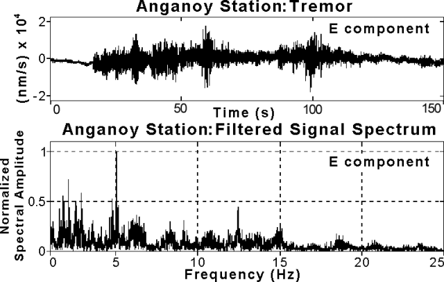 |
Figure 91. Main event seismic signal from 22 April 2000 at 1558 and its spectrum recorded at Anganoy station, 0.9 km E of Galeras's crater. Courtesy of OVSP. |
Field inspections on 27 April revealed that within the Chavas fumarole area, on the WSW edge of the main crater, a new crater approximately 8 x 4 m in area and 1.5 m deep had formed. Several gas-emitting fissures were observed along the crater wall. Temperatures recorded at the border of the new crater on 27 April and 1 May were 408°C and 393°C, respectively, which are not anomalously higher than those observed previously.
During 16 April-30 June 2000, radon-222 emissions from soil monitored at several stations around Galeras showed values of 78-2,966 picocuries/liter (pCi/l). These levels are similar to those found in previous months. The highest value corresponded to the Sismo 2 station, located 5 km NE of the summit.
Activity during May-October 2000. An eruptive event at 1411 on 18 May was seismically characterized by an initial LP event with a dominant frequency of ~2.1 Hz figure 92), followed by five spasmodic tremor episodes and nine more LP events. The last LP event was recorded at 1806 later that day.
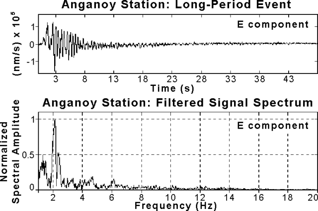 |
Figure 92. Main event seismic signal from 18 May 2000 at 1411 and its spectrum recorded at Anganoy station, 0.9 km E of Galeras's crater. Courtesy of OVSP. |
On 30 July at 0935 an earthquake swarm occurred 9 km ENE of the active cone, in the suburban area adjacent to the city of Pasto. The main event (M 4.5) was distinctly felt inside the city and in other neighboring communities. Aftershocks of lesser magnitude (M 2.3-3.4) continued through 4 August.
On 17 September 2000 at 2246 residents of Pasto and neighboring communities felt a M 3.9 event. Seismographs also detected aftershocks of M 2.6. Figure 93 shows a map view of volcano-tectonic earthquakes that occurred during July-October 2000. According to a report, movement of fluids within volcanic conduits remained at low levels.
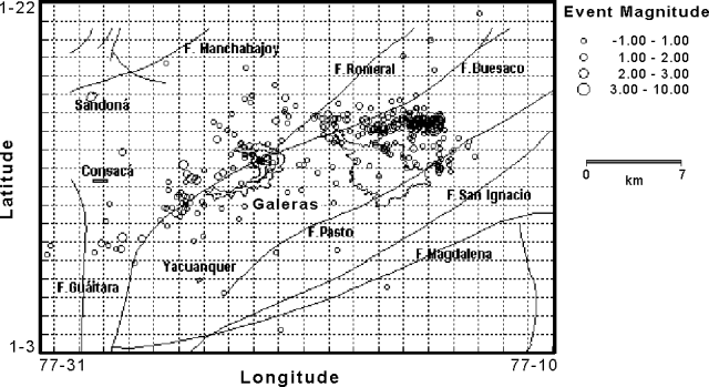 |
Figure 93. Map view showing volcano-tectonic earthquakes registered at Galeras during July-October 2000. Courtesy of OVSP. |
During 1 July-30 October 2000, radon-222 emission from soil monitored around Galeras showed average values lower than 3,000 pCi/l. Peak values at the Zanjón station, located 16 km NW of the summit, reached 9,620 pCi/l on 8 September. The highest values at the San Antonio 2 station, 14 km W of the summit, occurred on 13 July and 1 September with recorded values of 15,119 pCi/l and 11,587 pCi/l, respectively.
Activity during January-March 2001. A VT earthquake swarm located near the active crater occurred during 15-17 January. The swarm was composed of 17 quakes with depths less than 3.5 and M < 1.3. A single event on 24 January and two more on 26 January (M 2.3-2.7, depths of 6-8 km) followed. Seismometers recorded three further events (M 2.5-2.7, depths of 8-9 km) on 20, 21, and 23 March. The majority of the January-March 2001 earthquakes occurred NE of the summit and were felt in the neighboring communities of Pasto and Puyito. During the first quarter of 2001, instruments detected 52 events located within the active cone area (figures 94 and 95).
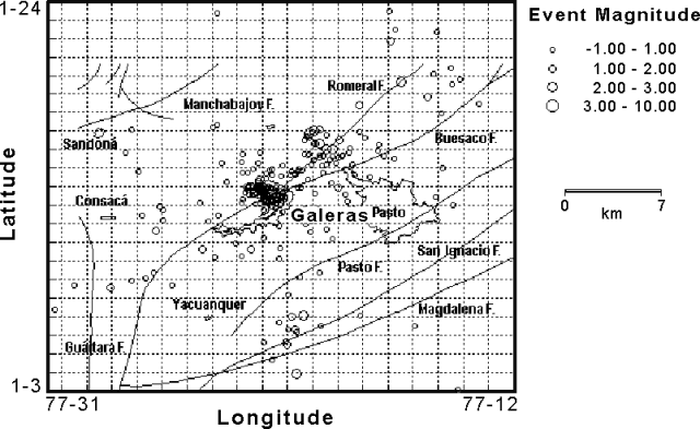 |
Figure 94. Map view showing volcano-tectonic earthquakes registered at Galeras during January-March 2001. Courtesy of OVSP. |
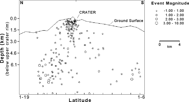 |
Figure 95. Cross-sectional view (N-S) showing earthquakes registered at Galeras during January-March 2001. Courtesy of OVSP. |
The occurrence of four tornillo ("screw-type") events with dominant frequencies of 3.2, 8.7, 12.8, and 18.7 Hz suggested that flow of volcanic material within interior conduits continued at low levels. Tremor episodes of short duration were also recorded. Spectral analysis of the registered tremor showed dominant frequencies of 2.3-3.5 Hz.
Field workers at Galeras near the Chavas fumarole (W of the active crater) reported hearing a sound similar to the rushing current of a river, which correlated with increased rates of gas emission.
During 2000 the temperature of the Deformes fumarole (S of the active crater) measured an average of 111°C and showed a slight cooling over time. The fumarole temperature averaged 100°C during the first three months of 2001.
During 1 January-31 March 2001, radon-222 emission from soil measured up to 4,000 pCi/l at most stations. The San Juan 1 station (10 km NE of the active cone) and Sismo 5 station (7 km N of the active cone) detected higher values of 6,754 pCi/l and 5,455 pCi/l, res
Geological Summary. Galeras, a stratovolcano with a large breached caldera located immediately west of the city of Pasto, is one of Colombia's most frequently active volcanoes. The dominantly andesitic complex has been active for more than 1 million years, and two major caldera collapse eruptions took place during the late Pleistocene. Long-term extensive hydrothermal alteration has contributed to large-scale edifice collapse on at least three occasions, producing debris avalanches that swept to the west and left a large open caldera inside which the modern cone has been constructed. Major explosive eruptions since the mid-Holocene have produced widespread tephra deposits and pyroclastic flows that swept all but the southern flanks. A central cone slightly lower than the caldera rim has been the site of numerous small-to-moderate eruptions since the time of the Spanish conquistadors.
Information Contacts: Patricia Ponce, Observatorio Vulcanológico y Sismológico de Pasto (OVSP), INGEOMINAS, Carrera 31, 18-07 Parque Infantil, P.O. Box 1795, Pasto, Colombia (URL: https://www2.sgc.gov.co/volcanes/index.html).

