Report on Mayon (Philippines) — April 2002
Bulletin of the Global Volcanism Network, vol. 27, no. 4 (April 2002)
Managing Editor: Richard Wunderman.
Mayon (Philippines) Declining activity prompts PHIVOLCS to lower Alert Level to 0
Please cite this report as:
Global Volcanism Program, 2002. Report on Mayon (Philippines) (Wunderman, R., ed.). Bulletin of the Global Volcanism Network, 27:4. Smithsonian Institution. https://doi.org/10.5479/si.GVP.BGVN200204-273030
Mayon
Philippines
13.257°N, 123.685°E; summit elev. 2462 m
All times are local (unless otherwise noted)
Eruptions at Mayon in June and July 2001 were followed by a decrease in seismic activity beginning on 10 August. Low-frequency volcanic earthquakes and SO2 fluxes were still high and were probably related to shallow magma degassing. While various monitoring parameters continued to reflect significant unrest, the general trend was one of declining activity (BGVN 26:08).
Volcanic activity remained low during August. There was relatively little seismicity, slight inflation, occasional observations of incandescence at the summit, and a moderate amount of steam emission. SO2 flux remained well above the baseline of 500 metric tons per day (t/d) (table 7). SO2 emission rates reflected continued degassing of cooling magma, and ground-deformation data continued to indicate the absence of magma intrusion. On 21 August the Alert Level was lowered to 3 and, following a continued decrease in activity, on 19 October it was lowered to 1.
Table 7. Earthquakes, tremor, and SO2 flux at Mayon during 13-30 August. Differences in reported daily and weekly data during 20-26 August could not be resolved by press time. Courtesy PHIVOLCS.
| Date | High-freq volc EQ's | Low-freq volc EQ's (amplitude) | High-freq short-duration volc tremor (amplitude) | Low-freq short-duration volc tremor (amplitude) | Avg SO2 flux (t/d) |
| 13-19 Aug 2001 | 4 | 62 | 40 (31.0, 58.0, 3.2, and 40.0 mm) | 17 | 4,757 |
| 21 Aug 2001 | -- | -- | -- | -- | 4,784 |
| 22 Aug 2001 | -- | 1 | 3 | 6 | 5,315 |
| 23 Aug 2001 | -- | 17 | -- | 6 | -- |
| 24 Aug 2001 | -- | 5 | 1 | -- | 3,989 |
| 25 Aug 2001 | -- | 4 (4.0 and 5.0 mm) | 2 | -- | 2,191 |
| 26 Aug 2001 | -- | 10 (12.0 mm) | -- | -- | 2,044 |
| 20-26 Aug 2001 | -- | 54 | 14 (14.0, 3.4, and 11.0 mm) | 10 | 3,771 |
| 27 Aug 2001 | -- | 13 (12.0 mm) | 1 (45.0 mm) | -- | 1,550 |
| 28 Aug 2001 | -- | 10 (7.0 mm) | 4 (7.0 mm) | -- | 3,863 |
| 29 Aug 2001 | -- | 3 (11.0 mm) | 3 (6.5 mm) | -- | 5,576 |
| 30 Aug 2001 | -- | 15 (14.0 mm) | -- | -- | -- |
News reports on 21 November stated that lahars were generated after several days of heavy rainfall mixed with unconsolidated material on the volcano's slopes. According to the civil defense, flooding caused more than 4,800 families to be evacuated from their homes.
The Philippine Institute of Volcanology and Seismology (PHIVOLCS) reported that since 19 October 2001, when the Alert Level was lowered to 1, all measured parameters had continued to decrease to near-baseline levels. Ground deformation data from electronic tiltmeters continued to indicate the volcano's deflated condition, and SO2 emission rates yielded relatively low values of 450-900 t/d. The observations implied that no active magma intrusion was occurring beneath the active cone. Although incandescence was still visible at night, PHIVOLCS suggested that it was likely due to still-hot magma beneath the crater. As a result of the low activity, on 5 February PHIVOLCS lowered the Alert Level to 0, but reminded the public to avoid the 6 km Permanent Danger Zone, and residents near major river channels emanating from the volcano were advised to be on alert during heavy rainfall because loose pyroclastic deposits could be remobilized as life-threatening stream flows and lahars.
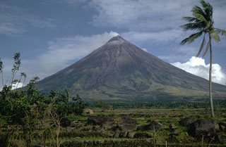
Geological Summary. Symmetrical Mayon, which rises above the Albay Gulf NW of Legazpi City, is the most active volcano of the Philippines. The steep upper slopes are capped by a small summit crater. Recorded eruptions since 1616 CE range from Strombolian to basaltic Plinian, with cyclical activity beginning with basaltic eruptions, followed by longer periods of andesitic lava flows. Eruptions occur predominately from the central conduit and have also produced lava flows that travel far down the flanks. Pyroclastic density currents and mudflows have commonly swept down many of the approximately 40 ravines that radiate from the summit and have often damaged populated lowland areas. A violent eruption in 1814 killed more than 1,200 people and devastated several towns.
Information Contacts: Philippine Institute of Volcanology and Seismology (PHIVOLCS), C.P. Garcia Ave., Univ. Philippines Campus, U.P. Diliman, 1101 Quezon City; Associated Press.

