Report on Kick 'em Jenny (Grenada) — June 2002
Bulletin of the Global Volcanism Network, vol. 27, no. 6 (June 2002)
Managing Editor: Richard Wunderman.
Kick 'em Jenny (Grenada) Bathymetry indicates circular summit crater with dome missing
Please cite this report as:
Global Volcanism Program, 2002. Report on Kick 'em Jenny (Grenada) (Wunderman, R., ed.). Bulletin of the Global Volcanism Network, 27:6. Smithsonian Institution. https://doi.org/10.5479/si.GVP.BGVN200206-360160
Kick 'em Jenny
Grenada
12.3°N, 61.64°W; summit elev. -185 m
All times are local (unless otherwise noted)
Submarine volcanic eruptions occurred at Kick-'em-Jenny during 4-6 December 2001 (BGVN 26:11). Following the 6 December seismicity, no further volcanic or seismic activity were recorded. On 8 December the Alert Level was reduced from Orange to Yellow.
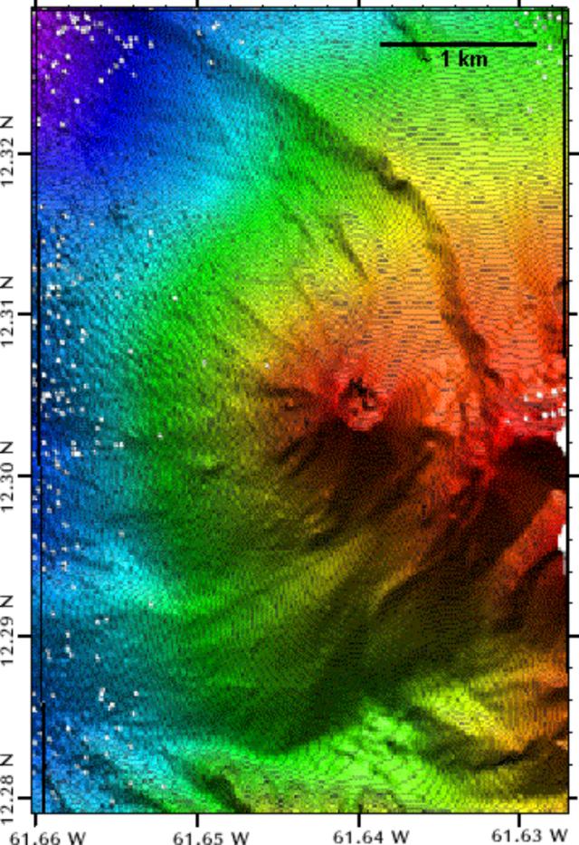
On 12 March 2002, the NOAA Research Vessel Ronald H. Brown conducted extensive mapping of Kick-'em Jenny using the SeaBeam® sonar mapping system (SeaBeam® is a registered trademark of L-3 Communications SeaBeam Instruments). The resulting bathymetric map (figure 3) shows several interesting features.
 |
Figure 3. Bathymetric sonar map of the Kick-'em-Jenny created on 12 March 2002. Courtesy Seismic Research Unit, University of the West Indies. |
The volcano's crater is clearly visible (immediately right of center on the image) on top of a symmetrical cone of about 1 km diameter. The crater is nearly perfectly circular with a diameter of ~330 m and a maximum depth of ~80 m. The crater center is located precisely at 12.3004° N, 61.6378° W. The dome, first noticed in 1978 when it almost filled the crater, has now disappeared except for a few remnants on the crater floor. The sonar image shows a breach of the crater to the NE. A prominent escarpment arcs around the E side of the cone and extends at least a few kilometers to the NE and S of the volcano. A series of ridges, principally in the cone's N to W sectors, trend radial or sub-radial to the cone's crater.
The topographic image furnished a bases for some new studies. Temperature-depth profiles were obtained within the crater and on the flanks, water samples were collected at a range of depths, and rock samples were collected from the summit region.
The Seismic Research Unit of the University of the West Indies reported that complete analysis of the results will take some time but preliminary analysis of the bathymetry confirms that the depth to the summit of the volcano has increased since the last detailed survey in 1989. Depth to the highest point on the crater rim is now ~183 m. The difference between this depth and the depths of ~160 m measured from 1978 to 1989 is probably accounted for by the fact that the dome that filled the crater beginning in 1977 has now completely disappeared.
Geological Summary. Kick 'em Jenny, an active submarine volcano 8 km off the N shore of Grenada, rises 1,300 m from the sea floor. Recent bathymetric surveys have shown evidence for a major arcuate collapse structure, which was the source of a submarine debris avalanche that traveled more than 15 km W. Bathymetry also revealed another submarine cone to the SE, Kick 'em Jack, and submarine lava domes to its S. These and subaerial tuff rings and lava flows at Ile de Caille and other nearby islands may represent a single large volcanic complex. Numerous eruptions have occurred since 1939, mostly documented by acoustic signals. Prior to the 1939 eruption, when an eruption cloud rose 275 m above the ocean and was witnessed by a large number of people in northern Grenada, there had been no written mention of the volcano. Eruptions have involved both explosive activity and the quiet extrusion of lava flows and lava domes in the summit crater; deep rumbling noises have sometimes been heard onshore. Recent eruptions have modified the morphology of the summit crater.
Information Contacts: John Shepard, Richie Robertson, Jan Lindsay, and Joan Latchman, Seismic Research Unit, University of the West Indies, St. Augustine, Trinidad, W.I. (URL: http://www.uwiseismic.com/).

