Report on Veniaminof (United States) — October 2002
Bulletin of the Global Volcanism Network, vol. 27, no. 10 (October 2002)
Managing Editor: Richard Wunderman.
Veniaminof (United States) Volcanic unrest, uncertain low-level eruptive activity in September 2002
Please cite this report as:
Global Volcanism Program, 2002. Report on Veniaminof (United States) (Wunderman, R., ed.). Bulletin of the Global Volcanism Network, 27:10. Smithsonian Institution. https://doi.org/10.5479/si.GVP.BGVN200210-312070
Veniaminof
United States
56.17°N, 159.38°W; summit elev. 2507 m
All times are local (unless otherwise noted)
On 10 September 2002 the Alaska Volcano Observatory (AVO) detected 1-minute-long pulses of low-frequency tremor arriving every 2-5 minutes on several seismic stations at Veniaminof. This type of seismicity is indicative of volcanic unrest. Retrospective analysis of seismic data suggested that tremor began as early as 8 September. The overall level of seismicity decreased through late September, but remained above the background level established during the summer of 2002.
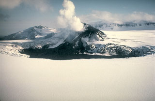
On 24 September, residents of Perryville, 35 km S of the volcano, reported and photographed small bursts of steam, possibly containing minor amounts of ash, rising just above the historically active intracaldera cinder cone. Without additional observations, AVO could not determine if this indicated very low-level eruptive activity or vigorous steaming from the cone. On several occasions of relatively clear weather conditions, AVO observed no signs of elevated temperature or ash emission on satellite imagery.
A satellite image recorded on 2 October suggested an apparent gray, diffuse deposit extending across the caldera from the historically active intracaldera cinder cone. This could reflect a small explosion, vigorous steam emission, or redistribution of material on the cone by strong winds. No thermal anomalies were observed on satellite imagery. AVO considered the activity at Veniaminof to be minor, but the exact nature of the unrest remained unknown. Due to the continuing seismicity and reports of unusual steaming, the Concern Color Code remained at Yellow.
Geological Summary. Veniaminof, on the Alaska Peninsula, is truncated by a steep-walled, 8 x 11 km, glacier-filled caldera that formed around 3,700 years ago. The caldera rim is up to 520 m high on the north, is deeply notched on the west by Cone Glacier, and is covered by an ice sheet on the south. Post-caldera vents are located along a NW-SE zone bisecting the caldera that extends 55 km from near the Bering Sea coast, across the caldera, and down the Pacific flank. Historical eruptions probably all originated from the westernmost and most prominent of two intra-caldera cones, which rises about 300 m above the surrounding icefield. The other cone is larger, and has a summit crater or caldera that may reach 2.5 km in diameter, but is more subdued and barely rises above the glacier surface.
Information Contacts: Alaska Volcano Observatory (AVO), a cooperative program of a) U.S. Geological Survey, 4200 University Drive, Anchorage, AK 99508-4667, USA, b) Geophysical Institute, University of Alaska, PO Box 757320, Fairbanks, AK 99775-7320, USA, and c) Alaska Division of Geological & Geophysical Surveys, 794 University Ave., Suite 200, Fairbanks, AK 99709, USA.

