Report on Langila (Papua New Guinea) — January 2003
Bulletin of the Global Volcanism Network, vol. 28, no. 1 (January 2003)
Managing Editor: Edward Venzke.
Langila (Papua New Guinea) Infrared data indicate activity during May-October 2002
Please cite this report as:
Global Volcanism Program, 2003. Report on Langila (Papua New Guinea) (Venzke, E., ed.). Bulletin of the Global Volcanism Network, 28:1. Smithsonian Institution. https://doi.org/10.5479/si.GVP.BGVN200301-252010
Langila
Papua New Guinea
5.525°S, 148.42°E; summit elev. 1330 m
All times are local (unless otherwise noted)
Based on information from a pilot report, the Darwin Volcanic Ash Advisory Center (VAAC) reported that an ash cloud from Langila was observed on 11 July 2002 at about 0900 and rose to a height of ~3.4 km. No ash was identifiable on satellite imagery. This was the first reported activity since October 2000 (BGVN 25:11). RVO noted that the observatory at Langila was broken into in 2000 and had its radio stolen. There are no telephones nearby, and since then they have had to rely on mailed reports (very infrequent), reports from pilots, and the Darwin VAAC.
MODVOLC Thermal Alerts, 2001-2002. MODIS thermal alerts occurred on 25 May, 19 and 26 June, 12-15, 24, and 26 August, and 13 October 2002; there were no alerts in 2001. The largest number of alert pixels was 3 on 14 August. The highest alert ratio was -0.648 on 24 August. Putting these two together suggests the most intense activity in mid-late August, but this could be severely biased by cloudy days. Available maps do not allow an accurate location of the summit, and are not of a scale to provide accurate registration. However, all but one of the alert pixels are within ~1 km of each other so there appears to be a spatially restricted event consistent with a short flow (less than a few hundred meters long) or a small dome or incandescent vent a few tens of meters across, which would affect more than one pixel when the pixel boundary fell across, or very close to, the flow, dome, or vent. Both recently active craters (Crater 1 and Crater 2) are also within a 1-km area, along a NE-SW trend, similar to the orientation of the alert pixels.
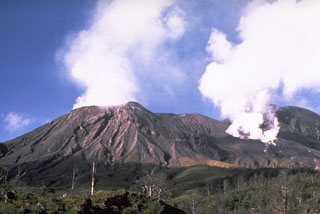
Geological Summary. Langila, one of the most active volcanoes of New Britain, consists of a group of four small overlapping composite basaltic-andesitic cones on the lower E flank of the extinct Talawe volcano in the Cape Gloucester area of NW New Britain. A rectangular, 2.5-km-long crater is breached widely to the SE; Langila was constructed NE of the breached crater of Talawe. An extensive lava field reaches the coast on the N and NE sides of Langila. Frequent mild-to-moderate explosive eruptions, sometimes accompanied by lava flows, have been recorded since the 19th century from three active craters at the summit. The youngest and smallest crater (no. 3 crater) was formed in 1960 and has a diameter of 150 m.
Information Contacts: Diego Coppola and David A. Rothery, Department of Earth Sciences, The Open University, Milton Keynes, MK7 6AA, United Kingdom; Darwin VAAC, Bureau of Meteorology, Northern Territory Regional Office, PO Box 40050, Casuarina, NT 0811, Australia (URL: http://www.bom.gov.au/info/vaac/); Steve Saunders, Rabaul Volcano Observatory (RVO), P.O. Box 386, Rabaul, Papua New Guinea.

