Report on Krakatau (Indonesia) — March 2003
Bulletin of the Global Volcanism Network, vol. 28, no. 3 (March 2003)
Managing Editor: Edward Venzke.
Krakatau (Indonesia) Volcanic earthquakes continue; thermal alerts during July-September 2001
Please cite this report as:
Global Volcanism Program, 2003. Report on Krakatau (Indonesia) (Venzke, E., ed.). Bulletin of the Global Volcanism Network, 28:3. Smithsonian Institution. https://doi.org/10.5479/si.GVP.BGVN200303-262000
Krakatau
Indonesia
6.1009°S, 105.4233°E; summit elev. 285 m
All times are local (unless otherwise noted)
Seismicity at Krakatau was dominated by volcanic and tectonic earthquakes during 30 December 2002-23 March 2003 (table 3). The hazard status remained unchanged at Alert Level 2.
Table 3. Seismicity at Krakatau during 30 December 2002-23 March 2003. Courtesy VSI.
| Date | Deep volcanic (A-type) | Shallow volcanic (B-type) | Tectonic |
| 30 Dec-05 Jan 2003 | 3 | 14 | 1 |
| 06 Jan-12 Jan 2003 | 14 | 60 | 3 |
| 13 Jan-19 Jan 2003 | 5 | 68 | 2 |
| 20 Jan-26 Jan 2003 | 9 | 30 | 3 |
| 27 Jan-02 Feb 2003 | 12 | 45 | 7 |
| 03 Feb-09 Feb 2003 | 2 | 49 | 2 |
| 10 Feb-16 Feb 2003 | 6 | 53 | 1 |
| 17 Feb-23 Feb 2003 | 10 | 26 | 2 |
| 24 Feb-02 Mar 2003 | 11 | 15 | 1 |
| 03 Mar-09 Mar 2003 | 4 | 28 | 2 |
| 10 Mar-16 Mar 2003 | 2 | 13 | 2 |
| 17 Mar-23 Mar 2003 | 5 | 58 | 3 |
Throughout 2001 and 2002, MODIS thermal alerts for Krakatau occurred only during July-September 2001. The first alert occurred on 31 July when one alert pixel was detected with an alert ratio of -0.793. The anomalies increased during August and on 9 August the anomaly consisted of two alert-pixels with a maximum alert ratio of -0.306. Other major anomalies occurred on 1 September (four alert-pixels with maximum alert ratio of -0.327) and on 17 September (two alert-pixels with maximum alert ratio of -0.284). These anomalies correspond to an increase of activity at Krakatau characterized by ash and bomb emission during August 2001 and an increase in the number of explosion and volcanic earthquakes during the first half of September 2001, reported by the Volcanological Survey of Indonesia (BGVN 26:09 and 27:09). The coordinates of the centers of the alert pixels are tightly grouped around the summit of the main cone. Bearing in mind that each pixel represents radiance from an area of ground more than 1 km across, the alert pixels could represent radiance from the active vent or from hot ejecta close to the vent.
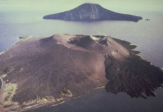
Geological Summary. The renowned Krakatau (frequently mis-named as Krakatoa) volcano lies in the Sunda Strait between Java and Sumatra. Collapse of an older edifice, perhaps in 416 or 535 CE, formed a 7-km-wide caldera. Remnants of that volcano are preserved in Verlaten and Lang Islands; subsequently the Rakata, Danan, and Perbuwatan cones were formed, coalescing to create the pre-1883 Krakatau Island. Caldera collapse during the catastrophic 1883 eruption destroyed Danan and Perbuwatan, and left only a remnant of Rakata. This eruption caused more than 36,000 fatalities, most as a result of tsunamis that swept the adjacent coastlines of Sumatra and Java. Pyroclastic surges traveled 40 km across the Sunda Strait and reached the Sumatra coast. After a quiescence of less than a half century, the post-collapse cone of Anak Krakatau (Child of Krakatau) was constructed within the 1883 caldera at a point between the former Danan and Perbuwatan cones. Anak Krakatau has been the site of frequent eruptions since 1927.
Information Contacts: Dali Ahmad, Volcanological Survey of Indonesia (VSI), Jalan Diponegoro No. 57, Bandung 40122, Indonesia (URL: http://www.vsi.esdm.go.id/); Diego Coppola and David A. Rothery, Department of Earth Sciences, The Open University, Milton Keynes, MK7 6AA, UK. Thermal alerts courtesy of the HIGP MODIS Thermal Alerts Team (URL: http://modis.higp.hawaii.edu/).

