Report on Nyiragongo (DR Congo) — May 2003
Bulletin of the Global Volcanism Network, vol. 28, no. 5 (May 2003)
Managing Editor: Edward Venzke.
Nyiragongo (DR Congo) 2002-2003 lava lake activity, thermal radiation, and CO2 and SO2 emissions
Please cite this report as:
Global Volcanism Program, 2003. Report on Nyiragongo (DR Congo) (Venzke, E., ed.). Bulletin of the Global Volcanism Network, 28:5. Smithsonian Institution. https://doi.org/10.5479/si.GVP.BGVN200305-223030
Nyiragongo
DR Congo
1.52°S, 29.25°E; summit elev. 3470 m
All times are local (unless otherwise noted)
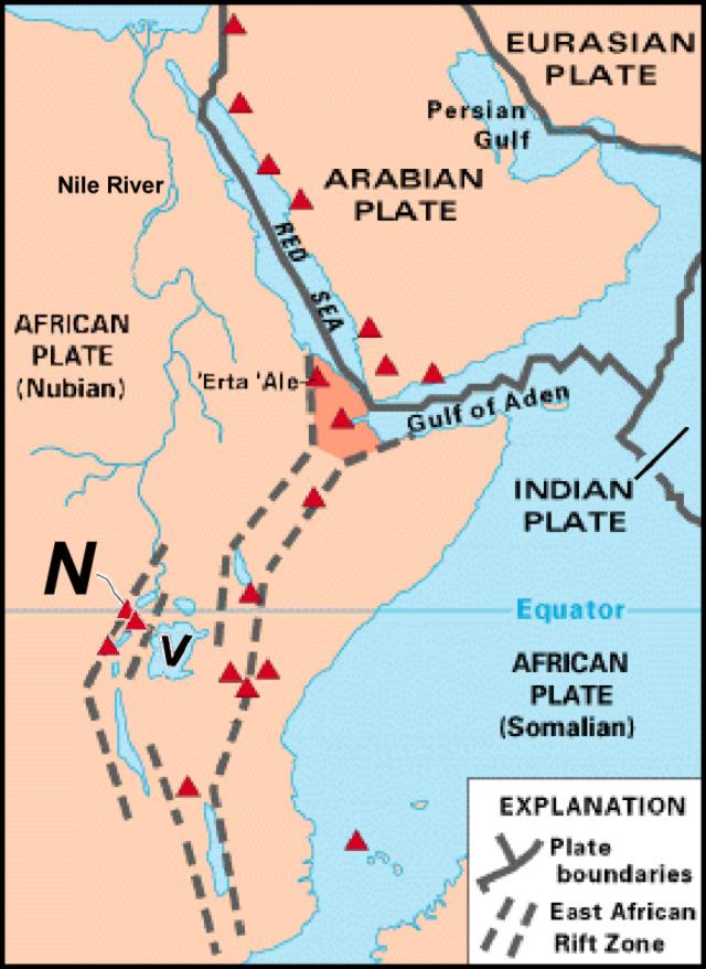
Nyiragongo, located along the East African Rift (figure 27), ceased generating flank lava flows following its January 2002 eruption, but remained active inside its summit crater where it hosts a restless lava lake. Observations made by staff from the Goma Volcano Observatory (GVO) in August 2002 included the opening of a new sinkhole, and measurements of CO2 and O2 gas concentrations at three fumarolic areas (locally termed mazukus). For context, handbook values for CO2 concentrations and their resulting symptoms in humans are discussed. The GVO has also brought to light reports from local residents of abnormally rapid ripening of picked bananas (and in some cases yams) prior to the January 2002 eruption.
This report also discusses GVO and resident volcanologist summit crater visits during late November 2002-early May 2003. In all cases the lava lake within the summit crater remained dynamic, with one or more windows on the crater floor exposing agitated molten lava. During this interval, degassing continued and tephra fell on the upper flanks. A summary of some ancillary observations such as seismicity measured on the GVO network is also provided.
A later section discusses ash plumes as described in aviation reports. Ash clouds extended as visible swaths on satellite imagery for up to ~100 km from the volcano. These reports include some as recent as 15 May 2003. The final section discusses MODIS thermal imagery during late 2002 through early 2003. The 2003 MODIS data reflect the lava lake seen deep within the summit crater. Finally, satellite data show atmospheric SO2 burdens for the Nyiragongo-Nyamuragira region during 13 December 2002 to 15 June 2003.
GVO's August 2002 field observations. On 12 August 2002 GVO was called to Bugarura village upslope from Munigi on the S flank. A new sinkhole had developed that morning, leaving a steaming opening ~3-4 m in diameter. Scientists could not see the opening's bottom through the steam, but they timed falling stones and estimated the sinkhole's depth at ~15 m. The odorless gas being emitted led them to believe that the steam chiefly represented vaporized groundwater.
GVO staff and collaborators hoped to advance gas monitoring efforts by measuring CO2 and other escaping gases at multiple sites in the region. They continued to make spot-checks with hand-held devices, but also sought a more-nearly continuous record from dedicated monitoring instruments. Although noxious gases are a familiar problem in volcanic areas, some of the gas concentrations in the rift are surprisingly high for areas adjacent human habitation. The Swahili word mazuku allegedly connotes places associated with "evil winds," and the term is currently used to describe fumarolic areas, which have also been described as dry gas vents.
Possible precursors to January 2002 eruption. In the weeks before the 17 January 2002 eruption, there were widespread reports of picked crops ripening at unusually rapid rates. From the settlements of Rusayo (8 km SW of the summit) and Katale (~18 km NNE of the summit and ~10 km NE of Nyamuragira's summit) people reported in early January that the normal 5-day ripening processes of bananas placed in the ground decreased to only 2 days. From Rusayo, people also reported that sweet potatoes, which are normally sun-dried on the ground surface, dried even without sun. GVO observers saw this first-hand and, as a result sought funds to hire porters and observe Nyiragongo directly, but the eruption began before the expedition started.
Although radiant or conductive heat may have been a factor (since heat speeds up the ripening process), heat's transport to broad areas on the surface by conduction through rocks would be comparatively slow. Heat at depth may have more rapidly reached the surface in the form of heated, liberated gases (such as steam). Discussions with gas chemist Vern Brown and a scan of the literature also revealed that the release of certain gases could conceivably have played another role as well. Both acetylene (C2H2, a colorless, flammable gas with an odor similar to garlic and slightly less dense than air) and C2H4 (ethylene, a colorless, faintly odorous gas less dense than air) speed up the ripening process in many agricultural products (including bananas and yams). Ethylene can cause banana peels to shift from green to yellow at low (ppm) concentrations. These gases occur naturally and may form or escape in association with heating organic material. In contrast, CO2 generally slows the ripening process. For the interval prior to the January 2002 eruption, observers lack documentation of increases in degassing or heating.
Seismicity and crater visits, November 2002-May 2003. Multiple GVO crater visits were documented: 23-25 November 2002; 9-10 and 21-22 January 2003; 4-5 and 25-26 February 2003; 18-19 March 2003; 22-24 April 2003; 6 May 2003. GVO also sent out occasional updates discussing seismicity and other observations.
During 23-25 November 2002, GVO team members Kasereka Mahinda, Ciraba Mateso, Arnaud Lemarchand, and Jacques Durieux watched the active lava lake on the crater floor. The lake was then located within the southern crater in the 16 November collapsed area. Two broad openings lay at the bottom of this new depression; both permitted viewers to see the lava lake's surface. A third, smaller opening ejected only high-temperature gases. The great quantity of gas occupying the bottom of the crater thwarted efforts to carry out a precise laser-based measurement of the depth to the lava-lake surface. The visual estimate for this depth from the summit was ~700 m.
The lava lake was very active, as it was before 1977. The lava surface was disturbed by the rise of abundant large gas bubbles. Breaking bubbles threw molten fragments onto the margins of the two openings. Consistent with the bubbles and constant degassing, a gas plume was visible at night from Goma. Occasionally, light dustings of tephra and Pele's hair came from the crater and fell on the surrounding areas. Although the current lake was impressive, the observers pointed out that the crater has contained a dynamic lava lake for nearly 50 years. The earlier lake's surface was much larger and stood nearly 500 m higher.
Jean-Christophe Komorowski accompanied GVO staff on a climb up Nyiragongo on 9-10 January 2003. While on the upper slopes, the climbers heard a few detonations associated with more energetic gas plumes. From the rim they saw a deep pit in the SW part of the inner crater. There were two vents on the crater floor separated by a thin rocky ridge. The SW vent (vent A) was characterized by a high-pressure fluctuating gas jet that gave off very loud roaring noises, along with flames of incandescent and combusting gases. Condensing steam clouds here were dense, rendering visual observations difficult. The other active vent (vent B) was just to the NE and consisted of an area of stable incandescence at least 100 m in diameter with an active lava fountain. Projections of lava spatter there took place every 30-60 seconds and typically reached 40-60 m in height.
The large area of incandescence indicated that a small lava lake must have been present deep in the pit, although the observers never saw the moving lava surface. Peak high-pressure degassing in vent A did not necessarily correlate with peak lava fountaining activity at vent B. Observations were conducted for several hours at night and during the day. Laser binocular measurements established the crater floor's depth at ~800 m. Very light ash consisting of Pele's hair and tears, and millimeter-sized vitric scoria fragments fell continuously on the rim. Conditions were made difficult at times when the SO2-rich gas plume blew towards the W.
Acid rain that flushed the volcano's SO2 gas plume, sampled at elevation 2,600 m, had a pH of 2.26. In contrast, rain collected in Kibati (below 2,000 m on the SSE flank) on 6 January had a pH of 6.15. Damage to about two-thirds of the vegetation by acid plume condensates was evident above 2,900 m on the SW and S flanks.
Compared to the last visit by GVO staff, 30-31 December 2002, degassing had increased significantly. However the level of the lava in the crater and/or lake had not risen and might have dropped lower in the conduit. The gas-plume height, measured regularly by the GVO, reached 4,500-5,000 m altitude. At times, although the very loud roaring sound remained unchanged, the entire crater became gas-filled to an extent that incandescence was entirely blocked, even from the vantage of surrounding villages. Information brought regularly to the attention of the GVO by the populations of Kibati, Mudja, Mutaho, and Rusayo villages attested to their exposure to the gas and ash plumes from Nyiragongo. Through at least early May 2003 the volcano's hazard status remained at yellow ("vigilance," the second lowest level on a 4-step scale).
Another climb enabled observers to peer into the crater during 21-22 January 2003 (figure 28). Compared to the 9-10 January observations, only one opening remained active inside the crater. The former vent A probably disappeared following a collapse. The active opening had about the same diameter and its lava fountain attained similar heights compared to earlier vent B observations. The level of the lava had not changed in the crater, remaining deep in the volcanic conduit. Degassing had increased significantly. Periodically more vigorous lava fountains sent smaller fragments to higher elevation that cooled to black scoria fragments. A small scoria cone had started to build around the active vent. Recent small lake overflows formed thin lobate lava sheets around the vent. The ascent velocity of individual gas plumes within the crater varied between 7 and 12 m/s.
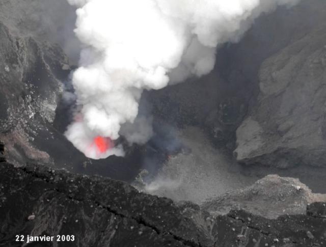 |
Figure 28. A photo of Nyiragongo's crater and the one opening in the lava lake visible on 22 January 2003. Copyrighted photo used with permission of GVO. |
A series of incandescent pits extended to the SE of the active pit along a line that corresponds to a major pre-existing fault-fracture system trending N25°W. This system transected the crater from NW to SE and linked with the upper Shaheru fracture and 1977 vent network that reactivated in 2002. A hot fracture zone trended N10°E-N20°E in the NE part of the crater wall. This zone had extended into the active deep crater forming a conspicuous, elongate, vertical-walled canyon. Observers frequently heard and saw rockfalls, and noted that those events often generated plumes that spread and deposited ash over local vegetation. Intra-crater ash reached 5 mm in thickness. The gas plume remained rich in SO2. Rain water collected at the top of Nyiragongo had a pH of 2.84.
The late-January plume height estimated during favorable atmospheric conditions by GVO members varied from 4,500 to 5,500 m altitude. Often, the prevailing wind carried ash, cinder, and Pele's hair S towards Kibati, Rusayo, Mudja, and Mutaho villages.
A 13 February GVO report said that for four consecutive days, Pele's hair fell in Goma, 17 km SSW. Although cloudy and foggy due to the start of the rainy season, Nyiragongo's plume reached at least 5 km above the crater. Between Goma and the Nyiragongo stood heavy gray-to-black ash-rich clouds. The fall of Pele's hair was due to lava fountains inside the crater.
The same report noted that seismicity was probably lower than the previous week and consisted of low tremor, few long-period earthquakes, and almost no tectonic earthquakes. Very small-amplitude seismic noise (small earthquakes) occurred, presumably due to collapses and perhaps intra-crater explosions.
GVO went on to say that one side effect of the ash falls was that villages around Goma had serious water shortages, since they rely on collecting rainfall. All UN agencies and NGOs were informed and asked to start potable water distribution around Goma. A few more physical problems might arise because of the Pele's hair, including stress on people's eyes and breathing. Crops around the volcano in some cases have been burned by acid rains and ash, while cattle might also suffer from ingestion of ash-polluted grass.
The 25-26 February ascent revealed more robust activity than observers had seen on their 4-5 February visit. By the latter date, all vegetation had died near the main crater. Approaching the rim in the upper 220 m of the ascent, tephra falls had accumulated to form deposits several centimeters thick; those, along with acidic plumes, had killed plants. The flora and fauna at lower elevations were still surviving, although they showed signs of serious stress. Loud sounds were audible several kilometers from the central crater. Intra-crater activity seemed intense, but thick fumes in the crater area thwarted day-time visibility. On 25 February views from the W rim revealed that a spatter cone had begun to grow on the crater floor. Lava fountaining occurred all night; discharging lava probably rose more than 100 m high, but it was difficult to assess the maximum rise height. Lava fountains chiefly came out at one spot, although a second, much smaller point of emission gave off mainly flames and sometimes scoria. Pele's hair fell all night long.
An update disseminated on 27 February 2003 noted that compared to previous weeks, during 21-27 February Nyiragongo's activity had decreased, although seismicity measured on the S flanks continued to contain low-amplitude tremor. S-flank seismicity also contained comparatively few long-period (LP) earthquakes. The update also said that local winds had begun to blow predominantly from the ENE, thus sweeping plumes and associated tephra falls clear of Goma. A 22 February visit to the SW-flank settlement of Rusayo revealed conspicuous tephra deposits on roofs and trapped in the crevices of banana trees.
During a visit to Nyiragongo on 18-19 March, GVO scientists observed a thick plume engulfing the crater. Two possible emission points were noted; one was related to powerful lava and ash emissions, and the other was related to a much weaker white-pink plume. An inner active cone was visible in the crater and was at least 200 m in diameter. Lava fountains rose to maximum heights of 150-200 m and as low as 50 m. Scoria ejection made observations difficult at times. Several permanent fumaroles, also observed during the previous visit, were seen in the crater.
Dario Tedesco noted that the cone morphology seemed slightly different from the trip 3 weeks earlier. He observed that on the N side of the crater a new platform had been formed, probably due to the continuous accumulation of ejecta, scoria, and ash. The team saw a huge lava fountain of at least 150-200 m in height. In contrast, when viewed in late February, fountains seemed to remain below ~100 m in height. The lava fountains generated abundant falling ash of millimeter size at the observation point, a process that lasted all night long.
Stronger and higher lava fountains, reaching almost 300 m high, were witnessed at 0230 on 19 March. The eruptive vigor as well as the intensity of the falling tephra declined at 0530. The last witnessed activity was of 50-m-high fountains. A second pit was noted on the E side of the crater that had been hidden during the night by the very thick plume.
For many days prior to visits on 22-24 April the seismic stations considered most representative of the Nyiragongo activity only registered very weak and steady continuous tremor. Although other types of seismicity were absent in the, A-type and C-type earthquakes occurred near the volcano. Despite the comparative seismic quiet, a prominent gas plume rose from the volcano. When weather conditions permitted, the plume top was measured at 5-6 km altitude.
The 22-24 April field excursion noted five distinct vents on the crater floor, almost continuous emissions of tephra, an agitated molten-lake surface that included emerging gas, and lava splashing 50-60 m high. Occasional waves of lava rolled across portions of the crater floor and walls. Excursion members also witnessed crater-wall collapses taking place along the NW and S fracture zones.
Widely felt earthquakes also continued in the region, presumably related to extension along the massive East African rift system. For example, three C-type events occurred on 23 April below Nyiragongo at a depth of ~15 km. During the whole day of 24 April, sustained tremor plus C-type events registered. On 25 April a few seismic events occurred amid sustained tremor. A main volcano-tectonic shock had been recorded and later a series of A-type events in the Nyiragongo field, between the S flank and Lake Kivu. Increasing tremor followed. For the rest of the week, the seismic network recorded a concentration of volcanic events to the NW and the S of the volcano, along the preferential fracture axis.
On 2-3 May unusually dense ash plumes were visible from Goma. Continuous ashfall occurred in many villages close to the volcano, and permanent tremor and long-period earthquakes were recorded. SO2 emission rates were relatively high during 1-6 May, with the largest emission on 3 May (~50,000 tons, see TOMS data below). UN peace keepers provided a 3 May helicopter flight that gave volcanologists clear views of the crater. The lava lake's molten surface appeared slightly larger than during a visit to the crater rim on 22-24 April. At that time a significant plume containing gas and ash rose high above the volcano.
On 6 May GVO climbers entered the village of Kibati, the usual departure point for the ascent, ~8 km from the crater rim. Kibati residents told how ash falls and acid rains had negatively affected local crops. For example, bean leaves had been burnt in many places. Along the ascent, at 2,260 m elevation, Pele's hair was found, including some intact individual strands 30 cm long. At 2,700 m elevation, thin ash grains completely covered the vegetation. At 3,200 m elevation on the S flank (~270 m below the summit), all vegetation had died.
Atmospheric conditions initially allowed quite clear views from the crater rim. The lava lake underwent violent outbursts from bursting of gas bubbles estimated at up to 40 m wide. The resulting projections of spatters and surges splashed on the walls of the pit. The lake had regained its former dimensions (~60 m across). The wider lake, recently seen from helicopter, had shrunken, leaving a solid platform on its side. Pressure of the escaping gases seemed very high and yielded a continuous roaring. GVO climbers again witnessed intermittent pale yellow-green flames hurling from the vents up to 50 m high.
At 0644 on 6 May a seismic shock was felt by the team on top of the volcano. It was recorded by the whole network as a low-amplitude long-period earthquake. Then, fog and gases halted further sightings into the crater. The fog lifted around 0100 on 7 May; at this time viewers saw a small narrow lava flow in the southern inner wall adjacent the active pit's margin ~200 m above the crater floor. The lava escaped out of what looked like a tunnel or tube. Although the lava descended at a steep angle and appeared to escape from the tube at a constant rate, its rate of advance remained slow. The lava front had not made it to the crater center. Below the tube, however, intricate individual lava flows had formed a long delta.
Aviation reports. A Volcanic Ash Advisory (VAA) for Nyiragongo was issued by the Toulouse Volcanic Ash Advisory Center (VAAC) on 6 March 2003. That advisory stated, "A cloud probably containing ash can be seen on [visible wavelength] METEOSAT imagery extending 100 NM [(nautical miles, 185 km)] westward from the volcano. "Several hours later the ash cloud was no longer visible. Advisories were also issue on 9, 12, 14, and 15 May 2003. The one for 9 May noted "Renewed activity since early May. Ash plume witnessed during a helicopter flight around early May up to 5-6 km above sea level. Many ash falls and acid rains all around the volcano." No cloud was observable due to convective weather clouds. The reports on 14 and 15 May stated, "According to Goma observatory [GVO], a plume of steam and ash is often emitted since early May. It may rise 1,500-2,500 m above the volcano's summit. No new message from Goma observatory since early May." Meteorological satellite (METEOSAT) imagery was unable to detect an ash cloud on 14 May due to weather clouds around the volcano.
MODVOLC Thermal Alerts. During early 2002 to early 2003 Nyiragongo was monitored on a daily basis with thermal satellite imagery (1-km pixel size). Investigators Matt Patrick, Luke Flynn, Harold Garbeil, Andy Harris, Eric Pilger, Glyn Williams-Jones, and Rob Wright used NASA's Moderate Resolution Imaging Spectroradiometer (MODIS) instrument and processed these data using the automated MODIS thermal alert system at the University of Hawaii, Manoa.
Prior to the January 2002 eruption, Nyiragongo activity appeared insignificant; anomalies were absent from the start of the MODIS-based alert system in April 2000, and through all of 2001. Anomalous pixels remained absent during 24 February-12 June 2002. The absence of anomalies could be explained either by a lack of exposure of the lava lake or by cloud cover obscuring the heat source from the satellite's view.
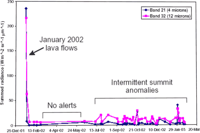
Nyiragongo's major effusive eruption in mid-January 2002 caused strong initial thermal anomalies (figure 29). Lava flows extending down the S flank to Lake Kivu resulted in anomalies as large as 45 pixels. Afterwards, the anomalies diminished quickly. Small intermittent anomalies (1-3 pixels) occurred near the summit for the remainder of 2002 and into early 2003, consistent with the kind of lava-lake activity described above.
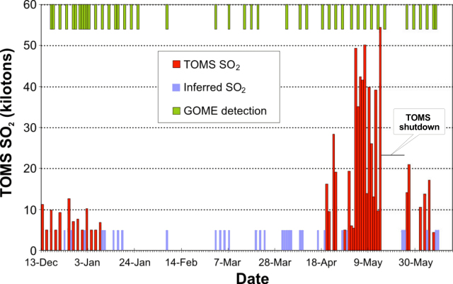
Atmospheric SO2. The Earth Probe Total Ozone Mapping Spectrometer (EP TOMS) SO2 data presented in figure 30 are preliminary. The bars indicated as "TOMS SO2" plotted on the lower axis of the chart represent EP TOMS measurements on days when the signal was large enough to allow retrieval of the SO2 mass. The height of these bars corresponds with the y-axis scale. Note that these values represent the SO2 mass in a satellite 'snapshot' of the volcanic cloud taken around local noon, and not an SO2 flux. The bars indicated as "Inferred SO2" on the lower axis denote days on which the presence of SO2 could be inferred from EP TOMS data, but the signal was too weak to allow retrieval of an atmospheric SO2 mass. Hence these bars are non-quantitative, but they indicate that non-trivial SO2 emissions probably occurred.
More, non-quantitative data appear as bars indicated as "GOME detection" along the upper axis of figure 30; in this case, showing dates when another instrument detected SO2 emissions in the region. These emission dates denote SO2 detection over central Africa by the European GOME (Global Ozone Monitoring Experiment) instrument aboard the ERS-2 satellite. GOME measurements are based on scans by a visible- and ultraviolet-wavelength spectrometer. GOME has inferior spatial and temporal resolution to EP TOMS, but is more sensitive to atmospheric SO2.
TOMS SO2 mass retrievals are dependent on the altitude of the volcanic plume and are also affected by meteorological cloud cover, and therefore may be adjusted as more information becomes available. The largest of these preliminary estimates during this interval was in excess of 50 kilotons (kt) SO2. These peaks in the first half of May 2003 were truncated by an instrument shutdown during 15-23 May. Given the crater and plume observations by GVO, and other data discussed above, the vast majority of the SO2 shown on figure 30 was probably emitted by Nyiragongo.
CO2 gas concentrations at three mazukus on the flanks of Nyiragongo in vicinity of Lac Vert at the ground surface measured up to ~40% by volume, but concentrations of the heavier-than-air gas dropped quickly with height above the ground surface. Spot measurements were made with a Geotechnical Instruments multi-gas landfill analyzer. Field notes reported CH4 concentrations consistently at zero and O2 concentrations at only one site where it was 22 vol. % at the ground surface and 16-17 vol. % nearby. The 15 August 2002 field excursion was led by GVO scientists Mathieu Yalire, Ciraba Mateso, and Kasereka Mahinda, with Chris Newhall present.
Effects of carbon dioxide. People in the region apparently understand the hazard of escaping CO2 gas, and in the past several years CO2 gas exposure has not led to reported human fatalities. CO2 gas, which is more dense than air at equivalent temperature and pressure, can be lethal to humans at 9-12 vol. % concentrations in as little as 5 minutes. The US standards for indoor air quality suggest that long-term human exposures remain below 0.1-0.2 vol. %, and that short-term (10- to 15-minute) exposures remain below 3 vol. %. The odor of CO2 is too weak to warn of dangerous concentrations. Table 9 lists some symptoms associated with the inhalation of air containing progressively higher levels of CO2.
Table 9. The AGA Gas Handbook included these CO2 gas concentrations (in volume percent) and accompanying symptoms for adults in good health (after Ahlberg, 1985).
| Volume % CO2 | Physical Symptoms |
| 2% | 50% increase in breathing rate. |
| 3% | 10-minute exposure limit; 100% increase in breathing rate. |
| 5% | 300% increase in breathing rate, headache and sweating may begin after about an hour. |
| 8% | Short-term exposure limit. |
| 8-10% | Headache after 10 or 15 minutes. Dizziness, buzzing in the ears, blood-pressure increase, high pulse rate, excitation, and nausea. |
| 10-18% | After a few minutes, cramps similar to epileptic fits loss of consciousness, and a sharp drop in blood pressure. The victims recover very quickly in fresh air. |
| 18-20% | Symptoms similar to those of a stroke. |
Reference. Ahlberg, K., 1985, AGA Gas Handbook: Properties & Uses of Industrial Gases, AB, Lidingo/Sweden, ISBN 91-970061-1-4 (out of print).
Geological Summary. The Nyiragongo stratovolcano contained a lava lake in its deep summit crater that was active for half a century before draining catastrophically through its outer flanks in 1977. The steep slopes contrast to the low profile of its neighboring shield volcano, Nyamuragira. Benches in the steep-walled, 1.2-km-wide summit crater mark levels of former lava lakes, which have been observed since the late-19th century. Two older stratovolcanoes, Baruta and Shaheru, are partially overlapped by Nyiragongo on the north and south. About 100 cones are located primarily along radial fissures south of Shaheru, east of the summit, and along a NE-SW zone extending as far as Lake Kivu. Many cones are buried by voluminous lava flows that extend long distances down the flanks, which is characterized by the eruption of foiditic rocks. The extremely fluid 1977 lava flows caused many fatalities, as did lava flows that inundated portions of the major city of Goma in January 2002.
Information Contacts: Celestin Kasereka Mahinda, Kavotha Kalendi Sadaka, Jean-Pierre Bajope, Ciraba Mateso, and Mathieu Yalire, Goma Volcano Observatory (GVO), Departement de Geophysique, Centre de Recherche en Sciences Naturelles, Lwiro, D.S. Bukavu, D.R. Congo; Dario Tedesco, Jacques Durieux, Jean-Christophe Komorowski, Jack Lockwood, Chris Newhall, Paolo Papale, Arnaud LeMarchand, and Orlando Vaselli, UN-OCHA resident volcanologists, c/o UN Office for the Coordination of Humanitarian Affairs, United Nations Geneva , Palais des Nations,1211 Geneva 10, Switzerland (URL: http://www.unog.ch); Tolouse Volcanic Ash Advisory Center (VAAC), Toulouse, Météo-France, 42 Avenue G. Coriolis, 31057 Toulouse Cedex, France (URL: http://www.meteo.fr/vaac/); Matt Patrick, Luke Flynn, Harold Garbeil, Andy Harris, Eric Pilger, Glyn Williams-Jones, and Rob Wright, Hawaii Institute of Geophysics and Planetology, University of Hawaii, Manoa (URL: http://modis.higp.hawaii.edu/); Vern Brown, President, ENMET Corporation, P.O. Box 979, Ann Arbor, Michigan 48106-0979 (URL: http://www.enmet.com/); Simon A. Carn, TOMS Volcanic Emissions Group, Joint Center for Earth Systems Technology (NASA/UMBC), University of Maryland Baltimore County, 1000 Hilltop Circle, Baltimore, MD 21250 USA (URL: https://so2.gsfc.nasa.gov/).

