Report on Ruang (Indonesia) — August 2003
Bulletin of the Global Volcanism Network, vol. 28, no. 8 (August 2003)
Managing Editor: Edward Venzke.
Ruang (Indonesia) Rapid decrease in activity following September 2002 eruption
Please cite this report as:
Global Volcanism Program, 2003. Report on Ruang (Indonesia) (Venzke, E., ed.). Bulletin of the Global Volcanism Network, 28:8. Smithsonian Institution. https://doi.org/10.5479/si.GVP.BGVN200308-267010
Ruang
Indonesia
2.3°N, 125.37°E; summit elev. 725 m
All times are local (unless otherwise noted)
Volcanic activity had decreased by 30 September 2002 after a strong eruption on the 25th. After the hazard status was lowered from Alert Level 4 to 3 on 30 September, it was dropped to Level 2 during the week of 7-13 October. However, activity continued to be higher than normal that week, with frequent strong emissions and "thick white ash" rising ~100 m above the summit. Emission earthquakes decreased (table 1). High-pressure plumes decreased in frequency from 14 October through 10 November, but "thick white ash" continued to rise from the summit. No ashfall was reported during October or November. Rainfall on 23 October caused a lahar. No volcanic or emission earthquakes were recorded during 4-10 November, and the Alert Level was reduced to level 1.
Table 1. Seismicity at Ruang, 7 October-10 November 2002. Courtesy of VSI.
| Date | Emission earthquakes | Tectonic earthquakes |
| 07 Oct-13 Oct 2002 | 3 | 46 |
| 14 Oct-20 Oct 2002 | 6 | 39 |
| 21 Oct-27 Oct 2002 | 2 | 85 |
| 28 Oct-03 Nov 2002 | 2 | 63 |
| 04 Nov-10 Nov 2002 | -- | 58 |
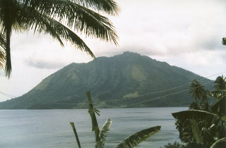
Geological Summary. Ruang volcano is the southernmost volcano in the Sangihe Island arc, north of Sulawesi Island; it is not the better known Raung volcano on Java. The 4 x 5 km island volcano is across a narrow strait SW of the larger Tagulandang Island. The summit contains a crater partially filled by a lava dome initially emplaced in 1904. Explosive eruptions recorded since 1808 have often been accompanied by lava dome formation and pyroclastic flows that have damaged inhabited areas.
Information Contacts: Dali Ahmad, Volcanological Survey of Indonesia (VSI), Jalan Diponegoro No. 57, Bandung 40122, Indonesia (URL: http://www.vsi. esdm.go.id/).

