Report on Nyiragongo (DR Congo) — October 2003
Bulletin of the Global Volcanism Network, vol. 28, no. 10 (October 2003)
Managing Editor: Edward Venzke.
Nyiragongo (DR Congo) Lava lake growing through pit-wall collapses; environmental damage
Please cite this report as:
Global Volcanism Program, 2003. Report on Nyiragongo (DR Congo) (Venzke, E., ed.). Bulletin of the Global Volcanism Network, 28:10. Smithsonian Institution. https://doi.org/10.5479/si.GVP.BGVN200310-223030
Nyiragongo
DR Congo
1.52°S, 29.25°E; summit elev. 3470 m
All times are local (unless otherwise noted)
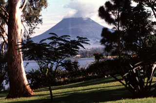
During the 3-month period from 2 August to 8 November 2003, volcanic activity was concentrated inside the Nyiragongo crater. An almost permanently boiling lava lake occupies the crater at the depth of 700 m. Although the level of the lake inside the crater seems to remain constant, its size is slowly growing due to collapses of the pit walls. Degassing has been significant, marked by a large gas plume above the crater which is generally blown W by the prevailing winds and extends several tens of kilometers. The impact of this activity on the environment is growing; inside the National Park, a 50 km2 area of forest was totally destroyed by volcanic gases and acid rains, and a zone with 50% destruction covers more than 700 km2, affecting crops such as potatoes, corn, beans, and bananas. In the same areas significant fluoride pollution has been detected, and tanks collecting rain water are showing fluoride concentrations up to 23 mg/l (WHO tolerance = 1.5 mg/l).
In the Nyiragongo area, long-period events are commonly detected but at reduced number and are mainly located NW and SW of the volcano. Seismicity is largely dominated by permanent tremor generated by the activity of the lava lake. Earthquakes related to fracturing continue, mainly S of Nyiragongo and NE of Nyamuragira (~ 15 km NW of Nyiragongo). No noticeable deformation change has been recorded along the fracture system between the two volcanoes.
Geological Summary. The Nyiragongo stratovolcano contained a lava lake in its deep summit crater that was active for half a century before draining catastrophically through its outer flanks in 1977. The steep slopes contrast to the low profile of its neighboring shield volcano, Nyamuragira. Benches in the steep-walled, 1.2-km-wide summit crater mark levels of former lava lakes, which have been observed since the late-19th century. Two older stratovolcanoes, Baruta and Shaheru, are partially overlapped by Nyiragongo on the north and south. About 100 cones are located primarily along radial fissures south of Shaheru, east of the summit, and along a NE-SW zone extending as far as Lake Kivu. Many cones are buried by voluminous lava flows that extend long distances down the flanks, which is characterized by the eruption of foiditic rocks. The extremely fluid 1977 lava flows caused many fatalities, as did lava flows that inundated portions of the major city of Goma in January 2002.
Information Contacts: Observatoire Volcanologique de Goma, Departement de Geophysique, Centre de Recherche en Sciences Naturelles, Lwiro, D.S. Bukavu, DR Congo.

