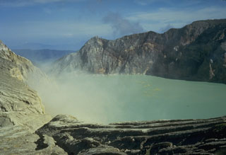
Report on Ijen (Indonesia) — October 2003
Bulletin of the Global Volcanism Network, vol. 28, no. 10 (October 2003)
Managing Editor: Edward Venzke.
Ijen (Indonesia) Shallow volcanic earthquakes and continuous tremor recorded in October
Please cite this report as:
Global Volcanism Program, 2003. Report on Ijen (Indonesia) (Venzke, E., ed.). Bulletin of the Global Volcanism Network, 28:10. Smithsonian Institution. https://doi.org/10.5479/si.GVP.BGVN200310-263350
Ijen
Indonesia
8.058°S, 114.242°E; summit elev. 2769 m
All times are local (unless otherwise noted)
The hazard status of Ijen was upgraded to Alert Level 2 (on a scale of 1-4) on 8 October. Seismicity the week of 6-12 October comprised four deep volcanic earthquakes, 21 shallow volcanic earthquakes, one emission event, and continuous tremor (0.5-2 mm amplitude). Only 16 shallow volcanic earthquakes were recorded the following week, along with continuous tremor (0.5-2 mm amplitude). Continuous tremor (0.5-4 mm amplitude) was recorded during 20-26 October, a week when the number of shallow volcanic events increased to 30. Gas plumes emitted from the crater rose up to 150 m high during October.
Geological Summary. The Ijen volcano complex at the eastern end of Java consists of a group of small stratovolcanoes constructed within the 20-km-wide Ijen (Kendeng) caldera. The north caldera wall forms a prominent arcuate ridge, but elsewhere the rim was buried by post-caldera volcanoes, including Gunung Merapi, which forms the high point of the complex. Immediately west of the Gunung Merapi stratovolcano is the historically active Kawah Ijen crater, which contains a nearly 1-km-wide, turquoise-colored, acid lake. Kawah Ijen is the site of a labor-intensive mining operation in which baskets of sulfur are hand-carried from the crater floor. Many other post-caldera cones and craters are located within the caldera or along its rim. The largest concentration of cones forms an E-W zone across the southern side of the caldera. Coffee plantations cover much of the caldera floor; nearby waterfalls and hot springs are tourist destinations.
Information Contacts: Dali Ahmad, Hetty Triastuty, Nia Haerani, and Suswati, Volcanological Survey of Indonesia (VSI), Jalan Diponegoro No. 57, Bandung 40122, Indonesia (URL: http://www.vsi.esdm.go.id/).

