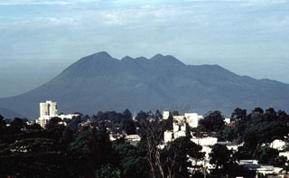
Report on Pacaya (Guatemala) — October 2003
Bulletin of the Global Volcanism Network, vol. 28, no. 10 (October 2003)
Managing Editor: Edward Venzke.
Pacaya (Guatemala) Frequent steam plumes
Please cite this report as:
Global Volcanism Program, 2003. Report on Pacaya (Guatemala) (Venzke, E., ed.). Bulletin of the Global Volcanism Network, 28:10. Smithsonian Institution. https://doi.org/10.5479/si.GVP.BGVN200310-342110
Pacaya
Guatemala
14.382°N, 90.601°W; summit elev. 2569 m
All times are local (unless otherwise noted)
Although incandescence from the long-term lava lake ended after June 2001, SO2 emission rates remained high when measured in January 2002 (BGVN 27:07). On 30 May 2002, the Washington Volcanic Ash Advisory Center (VAAC) received a report from Guatemala City indicating that Pacaya was active. Satellite imagery showed possible low-level ash near the summit. A very thin SW-drifting plume was again visible in satellite imagery on 17 June 2002, but the composition of the plume was unknown. A faint hotspot at the summit was also visible on infrared imagery. Visual observation on the afternoon 24 August 2002 from the SW showed copious white steam emissions from the summit crater (figure 34).
 |
Figure 34. View of Pacaya looking NNE on 24 August 2002. Only white steam emissions were visible. Courtesy of Jacquelyn Gluck. |
The Washington VAAC reported that on 5 July 2003 at 0715, a very thin ash and/or gas plume was visible on satellite imagery at an altitude of ~ 3 km extending ~ 7.5 km SW. By 1430 the plume was no longer visible, possibly obscured by thunderstorm clouds in the area. INSIVUMEH reported that only steam was emitted. Visible imagery on 9 August 2003 showed a narrow plume below 3 km altitude extending SW from the volcano, but its composition was unknown.
Reports provided by INSIVUMEH during the latter half of October 2003 indicated that during 15-21 October constant steam and abundant emissions of water and gas were being blown to the NNW and W of the volcano. These emissions continued through the end of the month. On 23 October, during periods of visibility, observers saw a line of off-white smoke across the S flank, which was dispersed in the area of the lava field near the Chupadero and the Caracol rivers. The next day observers saw a heavy column of off-white smoke rising ~ 600 m over the MacKenney crater. The plume continued through 27 October, but only to a height of ~ 400 m. The heavy gaseous cloud continued at the same height through 30 October.
Geological Summary. Eruptions from Pacaya are frequently visible from Guatemala City, the nation's capital. This complex basaltic volcano was constructed just outside the southern topographic rim of the 14 x 16 km Pleistocene Amatitlán caldera. A cluster of dacitic lava domes occupies the southern caldera floor. The post-caldera Pacaya massif includes the older Pacaya Viejo and Cerro Grande stratovolcanoes and the currently active Mackenney stratovolcano. Collapse of Pacaya Viejo between 600 and 1,500 years ago produced a debris-avalanche deposit that extends 25 km onto the Pacific coastal plain and left an arcuate scarp inside which the modern Pacaya volcano (Mackenney cone) grew. The NW-flank Cerro Chino crater was last active in the 19th century. During the past several decades, activity has consisted of frequent Strombolian eruptions with intermittent lava flow extrusion that has partially filled in the caldera moat and covered the flanks of Mackenney cone, punctuated by occasional larger explosive eruptions that partially destroy the summit.
Information Contacts: Instituto Nacional de Sismologia, Vulcanologia, Meteorologia e Hydrologia (INSIVUMEH), 7a Av. 14-57, Zona 13, Guatemala City, Guatemala (URL: http://www.insivumeh.gob.gt/); Washington Volcanic Ash Advisory Center (VAAC), Satellite Analysis Branch (SAB), NOAA/NESDIS E/SP23, NOAA Science Center Room 401, 5200 Auth Road, Camp Springs, MD 20746, USA (URL: http://www.ospo.noaa.gov/Products/atmosphere/vaac/); Jacquelyn Gluck, Global Volcanism Program, Smithsonian Institiution, Washington DC, 20560, USA.

