Report on Reventador (Ecuador) — November 2003
Bulletin of the Global Volcanism Network, vol. 28, no. 11 (November 2003)
Managing Editor: Edward Venzke.
Reventador (Ecuador) Variable seismicity, degassing, and recurring lahars
Please cite this report as:
Global Volcanism Program, 2003. Report on Reventador (Ecuador) (Venzke, E., ed.). Bulletin of the Global Volcanism Network, 28:11. Smithsonian Institution. https://doi.org/10.5479/si.GVP.BGVN200311-352010
Reventador
Ecuador
0.077°S, 77.656°W; summit elev. 3562 m
All times are local (unless otherwise noted)
This report contains updates from Reventador for July through November 2003. During this time seismicity varied from generally low to occasionally high. Lahars recurred, as rain and drainage systems continued to move tephra left after the eruptions that began on 3 November 2002 (BGVN 27:11, 28:02, and 28:06). Except for degassing, steam plumes, and the cooling of lava flows, further eruptive behavior (or cessation of activity) was not mentioned.
Activity during July-August 2003. Rainfall at Reventador during 7-13 July caused renewed movement of ash on the volcano's flanks. This led to lahars down the Montana River, and a consequent interruption in highway travel. Tremor associated with degassing was noted, with an increase during the last week of July and early August. Steam plumes were noted on 30 July and 2 August and lahars coincident with tremors were observed on 30 July. Seismicity was moderate, with about five volcano-tectonic (VT) events per day and a total of four tectonic events between 30 July and 3 August. These four events were located between 5.4 and 35 km away. The tectonic earthquake on 3 August registered the highest magnitude, M 3.2.
On 9 August detectors in three locations registered a lahar; this was later confirmed by staff from the Chaco-Santa Rosa station. Seismicity was low between 4 and 10 August, with six local tectonic events. Three of these occurred on 8 August, at varying depths, but all were within 10-12 km of the volcano. The second of these was the largest of any event that week, M 2.9. Seismicity stayed low through the end of the month, with an average of one VT event per day during the last week of August. Small fracture events related to the cooling of lava flows were noted. However, no rains capable of generating lahars were recorded, and there were no reports of steam or gas emissions.
Activity during September-October 2003. Reports were not available for the first three weeks of September and the first two weeks of October. During the week of 22-28 September, two lahar signals were registered, as well as 44 hybrid events, 43 VT events, and seven long-period (LP) events. During the following week, hybrid and LP events dropped to 17 and two events, respectively, but the number of VT events increased considerably, to 78. Lahars lasting ~ 4 hours each were recorded on 30 September and 1 October, following moderate rain on the 30th. During 13-19 October instruments registered 77 VT and 17 LP earthquakes (i.e., averaging 11 VT earthquakes and two LP earthquakes per day). Lahars were reported on 13, 14, and 19 October. During the following week, seismicity stayed at similar levels. Due to intense rains, more lahars were registered, on 20 and 22 October and again on 28 and 29 October. Traffic was again affected as a route had to be closed. Also between 27 October and 2 November, there was a small increase in the number of volcano-tectonic events.
Activity during November 2003. Seismicity remained constant, averaging 8-9 earthquakes each day. Following strong rains on 7 and 9 November, seismometers detected signals attributed to lahars. After the lahar signals had diminished, tremor was again detected. Lahar signals were also recorded on 11, 12, 14, and 26 November.
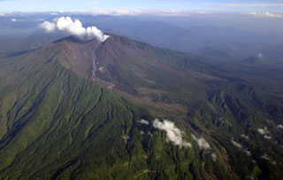
Geological Summary. Volcán El Reventador is the most frequently active of a chain of Ecuadorian volcanoes in the Cordillera Real, well east of the principal volcanic axis. The forested, dominantly andesitic stratovolcano has 4-km-wide avalanche scarp open to the E formed by edifice collapse. A young, unvegetated, cone rises from the amphitheater floor to a height comparable to the rim. It has been the source of numerous lava flows as well as explosive eruptions visible from Quito, about 90 km ESE. Frequent lahars in this region of heavy rainfall have left extensive deposits on the scarp slope. The largest recorded eruption took place in 2002, producing a 17-km-high eruption column, pyroclastic flows that traveled up to 8 km, and lava flows from summit and flank vents.
Information Contacts: Geophysical Institute (IG), Escuela Politécnica Nacional, Apartado 17-01-2759, Quito, Ecuador (URL: http://www.igepn.edu.ec/).

