Report on Ruapehu (New Zealand) — February 2004
Bulletin of the Global Volcanism Network, vol. 29, no. 2 (February 2004)
Managing Editor: Edward Venzke.
Ruapehu (New Zealand) Strategy, prediction, and management of crater-lake overflow and powerful lahar
Please cite this report as:
Global Volcanism Program, 2004. Report on Ruapehu (New Zealand) (Venzke, E., ed.). Bulletin of the Global Volcanism Network, 29:2. Smithsonian Institution. https://doi.org/10.5479/si.GVP.BGVN200402-241100
Ruapehu
New Zealand
39.28°S, 175.57°E; summit elev. 2797 m
All times are local (unless otherwise noted)
Citing risks about a lahar expected when an ash dam surrounding Ruapehu's crater collapses, the New Zealand government decided that draining, sluicing, or siphoning the volcano's crater lake to reduce the danger was too hazardous, reported Jo-Marie Brown in The New Zealand Times (10, 17, and 19 March 2004). The articles noted that, instead, the government decided to bolster extensive safety measures already in place around the volcano, including improving alarm systems. These new measures should provide warnings of lahar occurrences at least an hour and a half in advance. The government also elected to strengthen bridges and build an embankment to withstand lahars.
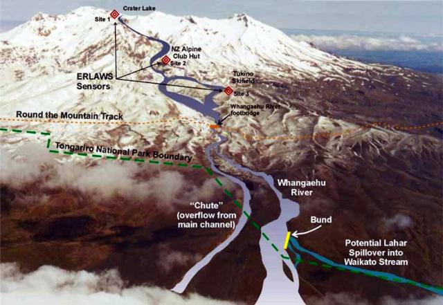
The New Zealand Department of Conservation has an extensive outreach to discuss the crater lake-lahar problem (figure 26). They point out that the crater lake on Mt. Ruapehu was refilling after it was emptied by eruptions in 1995 and 1996. This lake lies over the main active vent of the volcano. Before the eruptions, the level of the crater lake was controlled by an outlet that drained water across a sill of lava into the head of the Whangaehu Valley. During the 1995-96 eruptions, this outlet was blocked by 7 m of tephra (fine ash particles and other larger materials ejected by the volcano).
The Department also noted that since March 1999, the crater lake had risen 52 m and was filling at a rate of 5,300 m3 per day. On 15 March 2004 the lake's surface elevation was reported at 2,527.6 m above sea level. In mid-March 2004 the Department also reported that the lake was then ~ 96% full, a point ~ 2 m below the base of the tephra dam emplaced by the 1995-6 eruptions (the old overflow point). The predicted time for the lake to completely fill was given as early April 2004 to November 2004. An estimated 60 lahars have swept down the mountain's southern side through the Whangaehu Valley in the past 150 years. A lahar in 1953 killed 151 people at Tangiwai. The Department of Conservation reported additional details regarding the crater lake: there was low to normal hydrothermal activity; the water temperature on 15 March 2004 was 35°C; and the lake color was gray.
Geological Summary. Ruapehu, one of New Zealand's most active volcanoes, is a complex stratovolcano constructed during at least four cone-building episodes dating back to about 200,000 years ago. The dominantly andesitic 110 km3 volcanic massif is elongated in a NNE-SSW direction and surrounded by another 100 km3 ring plain of volcaniclastic debris, including the NW-flank Murimoto debris-avalanche deposit. A series of subplinian eruptions took place between about 22,600 and 10,000 years ago, but pyroclastic flows have been infrequent. The broad summait area and flank contain at least six vents active during the Holocene. Frequent mild-to-moderate explosive eruptions have been recorded from the Te Wai a-Moe (Crater Lake) vent, and tephra characteristics suggest that the crater lake may have formed as recently as 3,000 years ago. Lahars resulting from phreatic eruptions at the summit crater lake are a hazard to a ski area on the upper flanks and lower river valleys.
Information Contacts: The New Zealand Herald, PO Box 32, Auckland, New Zealand (URL: http://www.nzherald.co.nz/); New Zealand Department of Conservation, Private Bag, Turangi, New Zealand (URL: http://www.doc.govt.nz/); Institute of Geological & Nuclear Sciences (IGNS), Private Bag 2000, Wairakei, New Zealand (URL: http://www.gns/cri.nz/).


