Report on Shishaldin (United States) — June 2004
Bulletin of the Global Volcanism Network, vol. 29, no. 6 (June 2004)
Managing Editor: Richard Wunderman.
Shishaldin (United States) Seismic unrest and modest ash plumes in 2004
Please cite this report as:
Global Volcanism Program, 2004. Report on Shishaldin (United States) (Wunderman, R., ed.). Bulletin of the Global Volcanism Network, 29:6. Smithsonian Institution. https://doi.org/10.5479/si.GVP.BGVN200406-311360
Shishaldin
United States
54.756°N, 163.97°W; summit elev. 2857 m
All times are local (unless otherwise noted)
The last report on Shishaldin (BGVN 27:05) described an increase in backround seismicity in mid-May 2002. Specifically, there was an increase in shallow low-frequency earthquakes and several tremor-like signals. However, because there were no thermal anomolies visible on satellite imagery, and no reports of anomalous volcanic activity, Shishaldin remained at Concern Color Code Green.
Activity during August 2002. On 16 August 2002, the Alaska Volcano Observatory (AVO) received notification of a pilot report, via the National Weather Service (NWS) Alaska Aviation Weather Unit (AAWU), of volcanic activity. The pilot report indicated that Shishaldin appeared to be erupting, producing steam and dark clouds to 3.2 km altitude that moved to the NW-SE. A NWS observer in Cold Bay, ~ 100 km E of the volcano, reported a steam-rich plume coming from Shishaldin. As per operating policy, the AAWU issued an "eruption SIGMET" advising the aviation community of the possibility of airborne volcanic ash. Upon receiving the pilot report, the AVO immediately analyzed seismic and satellite data and determined that Shishaldin was at a normal background state and had not erupted. Further discussions with the observer in Cold Bay indicated that the steam plume was not uncommon. The last significant ash-producing eruptions of Shishaldin occurred during April-May 1999. Since that time, low-frequency seismic events and occasional steam plumes have characterized activity at the volcano. Shishaldin remained at Concern Color Code Green.
Activity during April-May 2004. The AVO raised the Concern Color Code at Shishaldin from Green to Yellow on 3 May due to unusual seismicity during the previous week. Seismicity changed from discrete earthquakes to more continuous ones, and tremor was observed for the first time since the most recent eruption ended in May 1999. Airwaves (acoustical waves traveling in air) accompanying earthquakes were recorded by the seismic network, suggesting that the source of seismicity had become more shallow. Satellite data showed no significant increase in ground temperature, nor had there been reports of increased steaming. However, AVO warned that activity at Shishaldin could increase rapidly and increased the frequency of their seismic-data analysis.
Seismic unrest continued during 30 April to 7 May, and was characterized by sequences of volcanic earthquakes and seismic tremor. The number of airwaves recorded by the seismic network diminished in comparison to the previous week, with weaker signals recorded.
Thermal anomalies at the summit were observed on satellite imagery under optimal viewing conditions. Retrospective analysis confirmed that these data, as well as similar signals observed in January 2004, were the first observed since August 2000. AVO saw no signs that an eruption was imminent. Shishaldin remained at Concern Color Code Yellow throughout the month.
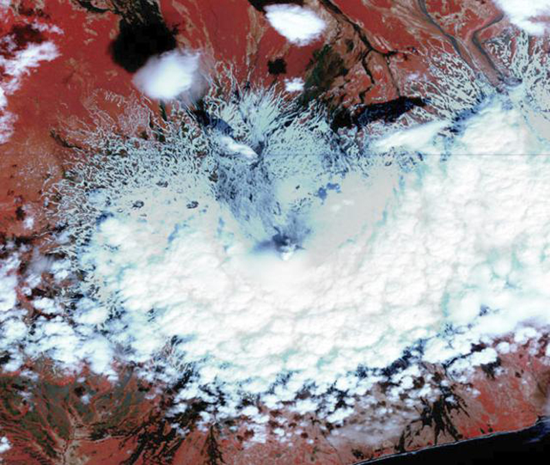
During 8-14 May seismic unrest continued, characterized by sequences of volcanic earthquakes, small explosions, and seismic tremor. A weak thermal anomaly observed at the summit on 11 May was similar to those detected occasionally since January 2004. On 16 May, a pilot reported an ash plume that rose ~ 300 m above the volcano's summit. Satellite imagery from 17 May (figure 4) showed a vigorous plume, possibly containing small amounts of ash, emanating from the summit. Seismic unrest during 14-21 May was characterized by weak seismic tremor and small explosions, and during 21-28 May also included occasional discrete low-frequency earthquakes. In addition, small explosion signals were recorded by a pressure sensor. Meteorological clouds obscured views of the volcano. Satellite data acquired at 0823 UTC (0023 ADT) on 29 May showed that the crater to continue to be warmer than background temperatures.
Activity during June-July 2004. Seismic unrest continued during 18 June-2 July, characterized by weak seismic tremor and occasional discrete low-frequency earthquakes. At roughly 0800 ADT on 24 June, pilots reported steam rising at least 100 m above Shishaldin's cone. Around that time, a possible weak thermal anomaly was visible on satellite imagery. Shishaldin remained at Concern Color Code Yellow.
Geological Summary. The symmetrical glacier-covered Shishaldin in the Aleutian Islands is the westernmost of three large stratovolcanoes in the eastern half of Unimak Island. The Aleuts named the volcano Sisquk, meaning "mountain which points the way when I am lost." Constructed atop an older glacially dissected edifice, it is largely basaltic in composition. Remnants of an older edifice are exposed on the W and NE sides at 1,500-1,800 m elevation. There are over two dozen pyroclastic cones on its NW flank, which is covered by massive aa lava flows. Frequent explosive activity, primarily consisting of Strombolian ash eruptions from the small summit crater, but sometimes producing lava flows, has been recorded since the 18th century. A steam plume often rises from the summit crater.
Information Contacts: Alaska Volcano Observatory (AVO), a cooperative program of a) U.S. Geological Survey, 4200 University Drive, Anchorage, AK 99508-4667, USA (URL: http://www.avo.alaska.edu/), b) Geophysical Institute, University of Alaska, PO Box 757320, Fairbanks, AK 99775-7320, USA, and c) Alaska Division of Geological & Geophysical Surveys, 794 University Ave., Suite 200, Fairbanks, AK 99709, USA.


