Report on Kick 'em Jenny (Grenada) — February 2005
Bulletin of the Global Volcanism Network, vol. 30, no. 2 (February 2005)
Managing Editor: Richard Wunderman.
Kick 'em Jenny (Grenada) Monitored and quiet; multi-beam finds craters and domes
Please cite this report as:
Global Volcanism Program, 2005. Report on Kick 'em Jenny (Grenada) (Wunderman, R., ed.). Bulletin of the Global Volcanism Network, 30:2. Smithsonian Institution. https://doi.org/10.5479/si.GVP.BGVN200502-360160
Kick 'em Jenny
Grenada
12.3°N, 61.64°W; summit elev. -185 m
All times are local (unless otherwise noted)
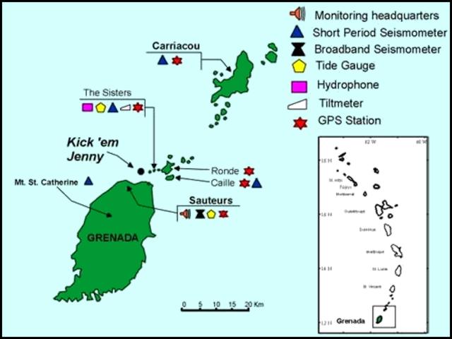
The University of West Indies Seismic Research Unit (SRU) has augmented their instrumental monitoring network and warning system at Kick 'em Jenny submarine volcano. In addition to long-period and broadband seismometers to sense earthquakes, they have also employed tide gauges to measure seawater disturbances, hydrophones to discern submarine explosions, and tilt meters and global positioning system (GPS) stations to detect long-term ground deformation. The instruments may disclose anomalies and critical symptoms before an eruption begins. Various combinations of these instruments were installed at Mt. St. Catherine, Sauteurs, The Sisters Rocks, Isle de Ronde, Isle de Caille, and Carriacou (figure 4).
The NSF Caribbean Tsunami Workshop was held in March 2004 (Mercado-Irizarry and Liu, 2004). The Workshop's program ended its Introduction section with this statement: " . . . Kick 'em Jenny, close to the islands of the southeastern Caribbean (just 10 km N of Grenada), is of much concern to the local governments. Past eruptions during the last century (1939, 1965) resulted in observed deep water tsunamis, with the one in 1939 being measured as 1 m high [Shepherd, 2001]. The concern is such that, for the first time (at least in the region), a banking institution (the Caribbean Development Bank) is funding a monitoring program [at] the volcano."
A 29 December 2004 article entitled "Tsunami warning system for the Caribbean," posted on the SRU website, also addressed the issue. It noted that, "The devastation caused by the tsunami which ravaged several Asian countries on 26th December 2004 has sparked discussion on the importance of a tsunami early warning system in the Caribbean. While in theory such a system may seem invaluable in light of the Asian disaster, scientists at the Seismic Research Unit currently believe that several factors should be seriously considered before assuming that a tsunami early warning system would be beneficial to the region. Head of the Seismic Research Unit, Dr. Richard Robertson, says that 'Before the region spends valuable resources on setting up new instruments for a tsunami early warning system, we need to strengthen our existing networks and focus on improving public education and communication activities with regard to geologic hazards in the region.'"
Gas release, T-phase seismicity, and minor eruption clouds. The question of whether or not there is strong fumarolic activity in the crater has been a source of speculation for a number of years. It has been suggested that warmed water rising in convection currents contributed to the reputation of the Kick 'em Jenny region for rough water. The emission of large quantities of bubbles was observed in 1989 when the submersible Johnson Sealink entered the crater a few months after the 1988 eruption (SEAN 14:05).
A water column containing a significant proportion of rising gas bubbles results in a local lowering of the seawater's density. (The rising bubbles displace some of the sea water, and at or near the sea surface they provide negligible support to the ship, thus resulting in a loss of buoyancy for ships passing over the volcano.) To account for this hazard, and the risk posed by ejecta, an exclusion zone 1.5 km in radius was created over the volcano (Shepherd, 2004).
At least 11 historical episodes of hydro-acoustic (T phase) signals have been detected since 1939 when an eruption cloud rose 275 m above the sea surface (Shepherd and Robson, 1967, Smith and Shepherd, 1995, Lindsay et al., 2005). Material was also ejected during the 1974 eruption, and the 1988 eruption was associated with turbulent discolored water (Lindsay and others, 2005). Some of these were described in Smithsonian reports dating back to 1977.
Regarding T-Phase waves. A short-period wave group from a seismic source that has propagated in part through the ocean is called T-phase or T(ertiary)-wave (Linehan, 1940; Tolstoy and Ewing, 1950; Walker and Hammond, 1998). The wave group propagates with low attenuation as hydro-acoustic (compressional) waves in the ocean, constrained within a low sound-speed wave guide (the sound fixing and ranging-SOFAR-channel) formed by the sound-speed structure in the ocean. The T-phase signal may be picked up by hydrophones in the ocean or by land seismometers. Upon incidence with the continental shelf/slope, the wave group is transformed into ordinary seismic waves that arrive considerably later than seismic wave groups from the same source that propagated entirely through the solid Earth.
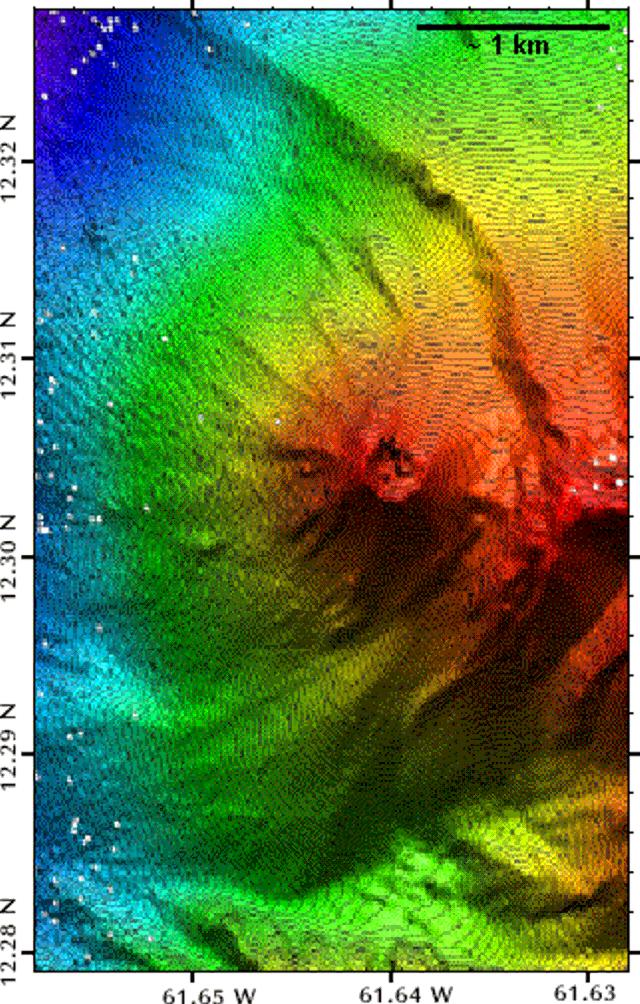
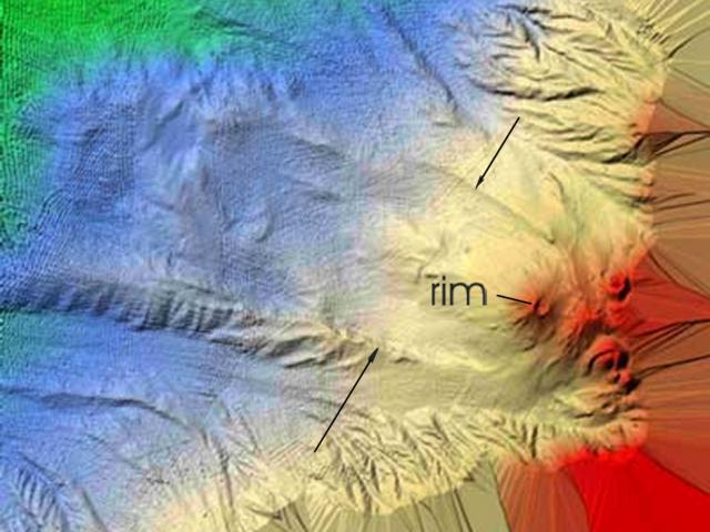
2002 and 2003 Surveys. A 2003 oceanographic survey of Kick 'em Jenny was conducted jointly by the National Oceanic and Atmospheric Agency (NOAA), SRU, and the University of Rhode Island (URI) using the NOAA Research VesselRonald H. Brown. This survey supplemented data obtained previously from a cruise passing the volcano on 12 March 2002 (BGVN 27:06). That effort produced the bathymetric image ... reproduced here as figure 5 (BGVN 27:06). The arcuate scarp on the image suggested that the volcano was once the scene of sector collapse. The inferred submarine debris avalanche has an estimated total volume of ~ 10 km3, and a maximum runout distance of at least 15 km (Sigurdsson and others, 2004; Shepherd 2004). The collapse clearly occurred prior to the growth of the small central edifice at Kick 'em Jenny. The ages of these various features remain unknown.
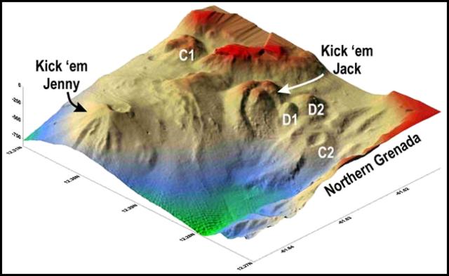
Figures 6 and 7 highlight the discovery of other volcanic features on the sea floor just E of Kick 'em Jenny. Little is known about them aside from their basic morphology illuminated by the 2003 survey. Discoveries near Kick 'em Jenny included three craters (C1, C2, and the largest, Kick 'em Jack) and two domes (D1 and D2). The mutual relations and ages of these newly recognized features remain uncertain.
References. Linehan, D., 1940, Earthquakes in the West Indian region: Transactions, American Geophysical Union, Pt. II, p. 229-232.
Mercado-Irizarry, A., and Liu, P. L.-F., 2004, NSF Caribbean Tsunami Workshop, 30-31 March 2004: San Juan Beach Hotel, San Juan, P.R., sponsored by the U. S. National Science Foundation, Puerto Rico State Emergency Management Agency, Department of Marine Sciences at the University of Puerto Rico at Mayagüez, and the Sea Grant Program at the University of Puerto Rico.
Lindsay, J. M., Shepherd, J.B., and Wilson D., 2005, Volcanic and scientific activity at Kick 'em Jenny submarine volcano 2001-2002: Implications for volcanic hazard in the Southern Grenadines, Lesser Antilles: Natural Hazards, v. 31, p. 1-24.
Shepherd, J.B., and Robson, G.R., 1967, The source of the T-phase recorded in the Eastern Caribbean on October 24, 1965: Bull. Seismol. Soc. Amer., v. 57, p. 227-234.
Shepherd, J.B., 2001, Marine and coastal hazards from Kick 'em Jenny submarine volcano, southern Grenadine Islands (copyrighted slide-show presentation): URL: http://www.uwichill.edu.bb/bnccde/grenada/grendoc/KickemJenny/kickemjenny.html.
Shepherd, J.B., 2004, Report on studies of Kick 'em Jenny submarine volcano March 2002 and March 2003 with updated estimates of marine and coastal hazards: The University of the West Indies Seismic Research Unit, KEJ Report Feb 2004, St. Augustine, Trinidad and Tobago, West Indies, 44 p.
Sigurdsson, H., Carey, S., and Wilson, D., 2004, Debris avalanche formation at Kick 'em Jenny submarine volcano, in NSF Caribbean Tsunami Workshop, 30-31 March 2004, San Juan Beach Hotel, San Juan, P.R. (URL: http://nsfctw.uprm.edu/agenda.html).
Smith, M., and Shepherd, J., 1995, Potential Cauchy-Poisson waves generated by submarine eruptions of Kick 'em Jenny volcano: Natural Hazards, v. 11, p. 75-94.
Tolstoy, I., and Ewing, M., 1950, The T phase of shallow-focus earthquakes: Bulletin of the Seismological Society of America, v. 40, p. 25-51.
Walker, D.A., and Hammond, S.R., 1998, Historical Gorda Ridge T-phase swarms; relationships to ridge structure and the tectonic and volcanic state of the ridge during 1964-1966: Deep-Sea Research Part II, v. 45, n. 12, p. 2531-2545.
Geological Summary. Kick 'em Jenny, an active submarine volcano 8 km off the N shore of Grenada, rises 1,300 m from the sea floor. Recent bathymetric surveys have shown evidence for a major arcuate collapse structure, which was the source of a submarine debris avalanche that traveled more than 15 km W. Bathymetry also revealed another submarine cone to the SE, Kick 'em Jack, and submarine lava domes to its S. These and subaerial tuff rings and lava flows at Ile de Caille and other nearby islands may represent a single large volcanic complex. Numerous eruptions have occurred since 1939, mostly documented by acoustic signals. Prior to the 1939 eruption, when an eruption cloud rose 275 m above the ocean and was witnessed by a large number of people in northern Grenada, there had been no written mention of the volcano. Eruptions have involved both explosive activity and the quiet extrusion of lava flows and lava domes in the summit crater; deep rumbling noises have sometimes been heard onshore. Recent eruptions have modified the morphology of the summit crater.
Information Contacts: Seismic Research Unit (SRU), The University of the West Indies, St. Augustine, Trinidad & Tobago, West Indies (URL: http://www.uwiseismic.com); Research Vessel Ronald H. Brown, National Oceanic and Atmospheric Agency (NOAA), Marine Operations Center, Atlantic, 439 West York Street, Norfolk, VA 23510-1145, USA (URL: http://oceanexplorer.noaa.gov/explorations/).


