Report on Manam (Papua New Guinea) — August 2005
Bulletin of the Global Volcanism Network, vol. 30, no. 8 (August 2005)
Managing Editor: Richard Wunderman.
Manam (Papua New Guinea) Comparatively mild eruptions with rare minor local ashfall
Please cite this report as:
Global Volcanism Program, 2005. Report on Manam (Papua New Guinea) (Wunderman, R., ed.). Bulletin of the Global Volcanism Network, 30:8. Smithsonian Institution. https://doi.org/10.5479/si.GVP.BGVN200508-251020
Manam
Papua New Guinea
4.08°S, 145.037°E; summit elev. 1807 m
All times are local (unless otherwise noted)
Manam erupted several times during October-December 2004 and January 2005 (BGVN 29:10, 29:11). The eruption on the evening of 27 January 2005 (BGVN 30:02) was more severe than the previous ones during the current eruption period; there were 14 people injured and one person killed at Warisi village. During April and May 2005, mild eruptive activity continued. Manam remained at Alert Level 2 from February 2005 through late May.
Throughout April 2005, both summit craters released occasional pale gray to brown ash clouds to a few hundred meters above the summit before being blown SW, W, and NW, resulting in fine ashfall. Occasional low rumbling and roaring noises from Southern Crater were heard on 23 April and 29 April. A weak to moderate glow accompanied by projections of incandescent lava fragments was visible on 28 April and 30 April. There were no audible noises and no night-time glow from the Main Crater.
April seismicity was at low-moderate level. Occasional weak volcanic tremors were recorded during the month. The daily number of low frequency earthquakes range between 700 and 1350.
A pilot reported an eruption on 13 June at 0445 UTC. The Darwin Volcanic Ash Advisory Centre (VAAC) reported that ash plumes from Manam were visible on satellite imagery on 16-17 June, 30 June, and 1-2 July. On 19 July ash from Manam was visible extending SW on satellite imagery. Ash was also visible on satellite imagery on 20 July. In all instances, the heights of the plumes were not reported.
According to the Rabaul Volcanological Observatory (RVO), during 15-21 August low-level volcanic activity continued at Manam, and the alert level was reduced to level 1. On 15 August, ash was emitted from Southern Crater. The Darwin VAAC reported that a low-level plume from Manam was visible on satellite imagery on 22 August. Mild eruptive activity continued during 22-28 August, with occasional emissions of weak-to-moderate ash plumes on several days. Ash clouds emitted on 22 and 26 August rose several hundred meters above the volcano's crater and drifted NW, depositing ash in areas between the towns of Jogari and Kuluguma, and beyond to Boisa Island.
During September, the Main Crater continued to release weak emissions of thin white-gray ash clouds. On 17 September, the ash clouds increased slightly in volume and were blown to the NW part of the island. No glow was observed at night and technical problems thwarted seismic recording. Manam remained at Alert Level 1, indicating low levels of activity, through 19 September.
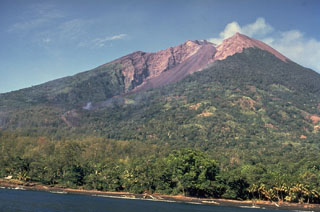
Geological Summary. The 10-km-wide island of Manam, lying 13 km off the northern coast of mainland Papua New Guinea, is one of the country's most active volcanoes. Four large radial valleys extend from the unvegetated summit of the conical basaltic-andesitic stratovolcano to its lower flanks. These valleys channel lava flows and pyroclastic avalanches that have sometimes reached the coast. Five small satellitic centers are located near the island's shoreline on the northern, southern, and western sides. Two summit craters are present; both are active, although most observed eruptions have originated from the southern crater, concentrating eruptive products during much of the past century into the SE valley. Frequent eruptions, typically of mild-to-moderate scale, have been recorded since 1616. Occasional larger eruptions have produced pyroclastic flows and lava flows that reached flat-lying coastal areas and entered the sea, sometimes impacting populated areas.
Information Contacts: Ima Itikarai, Rabaul Volcano Observatory (RVO), P.O. Box 386, Rabaul, Papua New Guinea; Andrew Tupper, Darwin Volcanic Ash Advisory Centre (VAAC), Bureau of Meteorology, Northern Territory Regional Office, PO Box 40050, Casuarina, Northern Territory 0811, Australia (URL: http://www.bom.gov.au/info/vaac/).

