Report on Barren Island (India) — September 2005
Bulletin of the Global Volcanism Network, vol. 30, no. 9 (September 2005)
Managing Editor: Richard Wunderman.
Barren Island (India) Lava emissions through September-August; high fire fountains; lava enters sea
Please cite this report as:
Global Volcanism Program, 2005. Report on Barren Island (India) (Wunderman, R., ed.). Bulletin of the Global Volcanism Network, 30:9. Smithsonian Institution. https://doi.org/10.5479/si.GVP.BGVN200509-260010
Barren Island
India
12.278°N, 93.858°E; summit elev. 354 m
All times are local (unless otherwise noted)
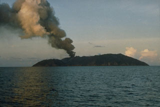
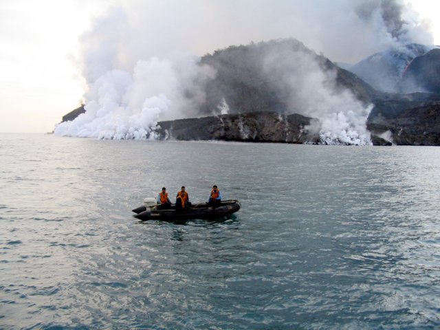
The latest eruption of Barren Island began about 28 May 2005 (BGVN 30:05 and 30:07). The following additional information regarding this eruption was provided by Dhanapati Haldar (Presidency College). A photograph (figure 11) taken on 21 July by the Indian Coast Guard indicated that the lava pouring from the main crater had cascaded down to arrive at two points on the W shore. The seawater boiled profusely.
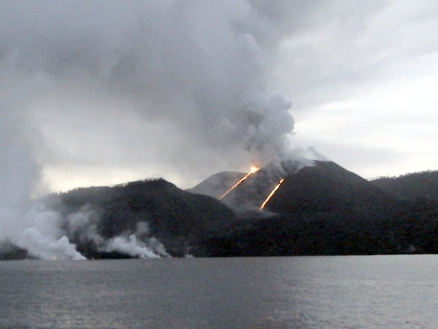
On 28 August, a senior geologist with the Central Ground Water Board (CGWB), A. Kar, made observations from a ship (figure 12). Kar noted that Strombolian eruptive activity had increased, and was both explosive and effusive in nature. The main crater and a newly created vent on the N flank were active. Streams of hot lava flowed down the slope of the cinder cone at the main crater. This cinder cone was built during the eruption in 1787-1832 and modified during subsequent eruptive pulses in 1991, in 1994-95, and (the current episode) in 2005. Kar's observations on 28 August 2005 noted that the descending lava flows traveled to the W shore, entering the sea near the lone preexisting landing site and ~ 250 m S of it. The latter was where the lava stream had met the sea during the 1994-95 eruption. Gas columns rose to more than 2 km, and fire fountains attained a height of around 300 m.
Kar visited the island again on 2 September and noted that eruptive activity was continuing unabated. As before, a thick gas plume hovered over the N part of the island, and hot lava still flowed down into the sea. The lava coming in contact with sea water was immediately broken into fine particles that were forcefully thrown into the air to a height of nearly 100 m. Accompanying steam rose to a height of about 300-400 m before being drawn away by the prevailing wind. The eruption column's top formed a spectacular mushroom of gas and smoke, blowing to the N. Subsequent reports received from the Indian Coast Guard indicated that the eruption was continuous until at least 25 September.
All the active vents so far observed during 2005 eruption, including the S footwall vent, lie in a zone trending almost N-S. This zone conforms with a pre-existing surficial fracture. This alignment of the active vents had been noted during the 1991 and 1994-95 eruptions, and, as previously mentioned, the lava streams of the current eruption retraced the 1991 and 1994-95 lava routes.
According to Haldar, recent lava samples show large (to 5 mm) megacrysts and phenocrysts of plagioclase (An 93-57), olivine (Fo 85-70), and diopside (Mg 47-44, Fe 16-10). The samples also included a groundmass of glass charged with microlites of plagioclase (An 50-45), augite, olivine, titanomagnetite, and rare orthopyroxene. The 2005 lavas contain relatively few olivine megacrysts, but are rich in plagioclase megacrysts, similar to the 1994-95 lavas.
The bulk chemical composition of the lava falls within the basalt field (table 2), which was comparable with the compositions of the 1994-95 lava. In comparison, the 2005 lava is slightly richer in both MgO and Na2O and slightly lower in SiO2.
Table 2. Analysis of one lava sample (number B1/05) erupted in June 2005 from Barren Island volcano. EMPA stands for electron microprobe analysis. Courtesy of Dhanapati Haldar.
| Analyzed Oxide | Bulk composition (%) | Groundmass glass composition (EMPA) (%) |
| SiO2 | 49.80 | 58.31 |
| TiO2 | 0.82 | 0.69 |
| Al2O3 | 21.04 | 19.38 |
| Fe2O3 (total) | 8.45 | -- |
| FeO (total) | -- | 6.16 |
| MnO | 0.14 | 0.02 |
| MgO | 4.23 | 1.30 |
| CaO | 10.91 | 7.13 |
| Na2O | 3.47 | 5.26 |
| K2O | 0.39 | 0.71 |
| P2O5 | 0.10 | 0.18 |
As this issue went to press Haldar noted that Barren Island continued to vigorously spew lava, gas, and ash at least as late as 10 November 2005. The eruption was unabated since the last week of May 2005.
Geological Summary. Barren Island, a possession of India in the Andaman Sea about 135 km NE of Port Blair in the Andaman Islands, is the only historically active volcano along the N-S volcanic arc extending between Sumatra and Burma (Myanmar). It is the emergent summit of a volcano that rises from a depth of about 2250 m. The small, uninhabited 3-km-wide island contains a roughly 2-km-wide caldera with walls 250-350 m high. The caldera, which is open to the sea on the west, was created during a major explosive eruption in the late Pleistocene that produced pyroclastic-flow and -surge deposits. Historical eruptions have changed the morphology of the pyroclastic cone in the center of the caldera, and lava flows that fill much of the caldera floor have reached the sea along the western coast.
Information Contacts: Dhanapati Haldar, Presidency College, Kolkata, 4/3K/2 Ho-Chi-Min Sarani, Shakuntala Park, Biren Roy Road (West), Kolkata-700 061, India; Geological Survey of India, 27 Jawaharlal Nehru road, Kolkata 700 016, India (URL: https://www.gsi.gov.in/); Indian Coast Guard, National Stadium Complex, New Delhi 110 001, India (URL: http://indiancoastguard.nic.in/indiancoastguard/).


