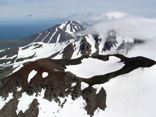
Report on Atka Volcanic Complex (United States) — February 2006
Bulletin of the Global Volcanism Network, vol. 31, no. 2 (February 2006)
Managing Editor: Richard Wunderman.
Atka Volcanic Complex (United States) Small steam-and-ash eruption on 23 February 2005 at Korovin
Please cite this report as:
Global Volcanism Program, 2006. Report on Atka Volcanic Complex (United States) (Wunderman, R., ed.). Bulletin of the Global Volcanism Network, 31:2. Smithsonian Institution. https://doi.org/10.5479/si.GVP.BGVN200602-311160
Atka Volcanic Complex
United States
52.331°N, 174.139°W; summit elev. 1518 m
All times are local (unless otherwise noted)
[What follows is a corrected report taking advantage of new information.]
2005 activity. The Alaska Volcano Observatory (AVO) received a report that a sudden minor steam-and-ash eruption occurred at Korovin around 1900 on 23 February [2005]. Korovin is an active volcano ... in the central Aleutian islands, ~ 184 km E of Adak island and ~ 600 km W of Unimak island, and 1,760 km SW of Anchorage. According to residents of Atka village near Korovin, the initial ash burst rose to an altitude of ~ 2.4 km and drifted E. It was followed by several smaller ash-and-steam bursts.
No ashfall was reported in Atka village, nor were there reports of accompanying volcanic odors, earthquakes, or larger volcanic explosions. Satellite images of the volcano did not clearly show the presence of ash or any thermal anomalies. But, on the morning of 24 February [2005] (the morning after the eruption) the volcano was still steaming with some vigor. During the period 25 February-4 March [2005], cloud cover prohibited satellite views of the volcano, and no unusual seismicity registered.
Although Korovin was not monitored by a standard AVO seismic network, Atka village hosts a seismic station operated by the Alaska Earthquake Information Center. [No activity was reported following the 23 February 2005 eruption until January 2006].
2006 activity. Distinct seismic signals indicating unrest were recorded on 17, 18, and 21 January 2006, and 21 and 22 February 2006. The latter day (22nd) brought an unusually sustained, 11-minute-long signal.
After 22 February 2006, seismicity decreased and distinct seismic signals like those recorded earlier were not detected. An 8 March report noted that Korovin's rate of occurrence of micro-earthquakes had stabilized and then declined, and "it has been close to background levels for the past week."
For some days after 22 February, clouds obscured satellite views of the volcano. However, on the 22nd an aviator reported that, although the summit area was obscured by clouds, no signs of ashfall on the flanks or any steam plume was seen. On 23 February, observers in the village of Atka noted the lack of obvious signs of activity. AVO received no short-term reports of precursory volcanism to indicate an imminent eruption.
Seismicity at Korovin remained slightly above background levels during 24 February to 3 March 2006. Clouds continued to mask satellite views of the volcano, and AVO received no further reports of activity.
Geological Summary. The Atka Volcanic Complex consists of a central shield and Pleistocene caldera and four notable volcanic cones. A major explosive dacitic eruption accompanied formation of the caldera about 500,000 to 300,000 years ago; approximately half of the caldera rime remains, open towards the NW. The Sarichef cone, ~5 km ESE of the caldera rim, retains a symmetrical profile, unlike most other heavily eroded features outside the caldera to the S and W. The Kliuchef stratovolcano grew within the caldera and exhibits five eruptive vents striking NE, including two at the summit, that have been active in the Holocene. A 700-m-diameter crater 1 km NE of the summit may have been the source vent for a large 1812 CE eruption. Hot springs and fumaroles are located on the flanks of Kliuchef and in a glacial valley to the SW. The most frequently active volcano of the complex is Korovin, at the NE tip of Atka Island about 5 km N of Kliuchef. An 800-m-diameter crater on the SE side of the summit contains a deep circular pit that sometimes contains a crater lake thought to be the source of phreatic ash explosions. The smaller Konia cone, slightly offset to the E, lies between Kliuchef and Korovin. Most of the lava flows in the complex are basaltic, though some dacitic flows are also present.
Information Contacts: Alaska Volcano Observatory (AVO), a cooperative program of the U.S. Geological Survey, 4200 University Drive, Anchorage, AK 99508-4667, USA (URL: http://www.avo.alaska.edu/), Geophysical Institute, University of Alaska, PO Box 757320, Fairbanks, AK 99775-7320, USA, and Alaska Division of Geological & Geophysical Surveys, 794 University Ave., Suite 200, Fairbanks, AK 99709, USA.

