Report on San Cristobal (Nicaragua) — September 2006
Bulletin of the Global Volcanism Network, vol. 31, no. 9 (September 2006)
Managing Editor: Richard Wunderman.
San Cristobal (Nicaragua) Multi-year update: 13 June 2004, local ash fall; early 2006, small eruptions
Please cite this report as:
Global Volcanism Program, 2006. Report on San Cristobal (Nicaragua) (Wunderman, R., ed.). Bulletin of the Global Volcanism Network, 31:9. Smithsonian Institution. https://doi.org/10.5479/si.GVP.BGVN200609-344020
San Cristobal
Nicaragua
12.702°N, 87.004°W; summit elev. 1745 m
All times are local (unless otherwise noted)
San Cristóbal was last reported on in BGVN 28:10, covering intermittent gas and ash emissions between August 2002 and September 2003. The Instituto Nicarag?ense de Estudios Territoriales (INETER) noted that low seismicity and minor gas and ash emissions characterized the period from October 2003 to June 2004.
On 7 June 2004 a lahar flowed more than 600 m. On 13 June 2004, an eruption caused ash to fall in the communities of Las Rojas, El Chonco, and El Viejo.
On 20 July 2004 at 1430, an M 4.3 earthquake occurred to the N of the volcano at a depth of less than four km. The earthquake was felt in the regions of Carlos Fonseca, Villa 15 de Julio, La Suiza, Las Rojas, Mocorón, San Jose del Obraje, Santa Carlota, San Antonio, Ranchería, and bordering regions. Some houses were damaged and the population was alarmed. The earthquake was felt in Matagalpa and Ocotal, and San Cristóbal emitted abundant gases for the following two days. During the rest of July, 95 aftershocks were registered; residents felt two more earthquakes, which occurred on 23 and 30 July.
During August to early December 2004, minor seismicity and ash and gas emissions were the norm. Ash explosions occurred on 3, 4, and 7 December. According to local people, ash fell in Chinandega and El Viejo.
The next available report discussed 16-22 November 2005. INETER detected an increase in seismicity beginning on 19 November. Increased tremor was interpreted as being related to gas and ash emissions. Ash fell W of the volcano and near the town of Chinandega, ~ 15 km SW of the volcano. The amount of tremor decreased later.
According to an Associated Press news report, explosions on 6 March 2006 produced columns of ash and gas that rose above the volcano. The activity ceased by 8 March and there were no evacuations.
INETER noted that phreatomagmatic eruptions began at San Cristóbal on 21 April 2006. Seismic tremor increased the same day around 1300. Small explosions produced gas-and-ash plumes during 21-23 April that deposited small amounts of ash in nearby towns.
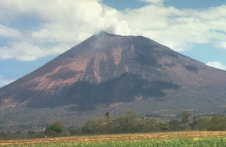
Geological Summary. The San Cristóbal volcanic complex, consisting of five principal volcanic edifices, forms the NW end of the Marrabios Range. The symmetrical 1745-m-high youngest cone, named San Cristóbal (also known as El Viejo), is Nicaragua's highest volcano and is capped by a 500 x 600 m wide crater. El Chonco, with several flank lava domes, is located 4 km W of San Cristóbal; it and the eroded Moyotepe volcano, 4 km NE of San Cristóbal, are of Pleistocene age. Volcán Casita, containing an elongated summit crater, lies immediately east of San Cristóbal and was the site of a catastrophic landslide and lahar in 1998. The Plio-Pleistocene La Pelona caldera is located at the eastern end of the complex. Historical eruptions from San Cristóbal, consisting of small-to-moderate explosive activity, have been reported since the 16th century. Some other 16th-century eruptions attributed to Casita volcano are uncertain and may pertain to other Marrabios Range volcanoes.
Information Contacts: Virginia Tenorio, Emilio Talavera, and Martha Navarro, Instituto Nicaraguense de Estudios Territoriales (INETER), Apartado Postal 2110, Managua, Nicaragua (URL: http://www.ineter.gob.ni/); Associated Press (URL: http://www.ap.org/).

