Report on Ruapehu (New Zealand) — February 2007
Bulletin of the Global Volcanism Network, vol. 32, no. 2 (February 2007)
Managing Editor: Richard Wunderman.
Ruapehu (New Zealand) Minor October 2006 eruption and concern of impending lahar
Please cite this report as:
Global Volcanism Program, 2007. Report on Ruapehu (New Zealand) (Wunderman, R., ed.). Bulletin of the Global Volcanism Network, 32:2. Smithsonian Institution. https://doi.org/10.5479/si.GVP.BGVN200702-241100
Ruapehu
New Zealand
39.28°S, 175.57°E; summit elev. 2797 m
All times are local (unless otherwise noted)
A moderate volcanic earthquake struck Ruapehu at 2230 on 4 October 2006. The M 2.8 event falsely triggered the lahar warning system. A visit to the crater lake on 7 October revealed evidence that a small hydrothermal eruption had occurred. Wave action reached up to 4-5 m above the lake surface around the basin, but was insufficient to overflow the tephra dam where it might have formed a lahar on the outer slopes. Since the last measurement (date not specified) the lake's temperature rose ~8°C, and the water level increased ~ 1 m. Both of these effects were expected. Seismic activity remained at typical background levels on 7 October 2006.
At about 1300 on 18 March 2007, Crater Lake partly emptied and its runoff traveled rapidly downstream as a powerful lahar. A subsequent issue will discuss that dramatic event and its impact.
Since the last report in February 2004 (BGVN 29:02), from May 2003 to October 2006, there were eight alerts issued by the Institute of Geological & Nuclear Sciences (IGNS, table 12), indicating appreciable changes in both the level of the lake and its temperature; these alerts can be compared with the temperature data (table 13).
Table 12. Institute of Geological & Nuclear Sciences (IGNS) alerts posted for Ruapehu volcano, May 2003 to October 2006. Compiled from IGNS reports.
| Alert Date | Alert Comments |
| 26 May 2003 | Steam plumes, volcanic tremor, Crater Lake temperatures increase |
| 15 Nov 2004 | Volcanic tremor, Crater Lake temperature increase |
| 22 Aug 2005 | Crater Lake temperature increase |
| 13 Sep 2005 | Steam plumes |
| 18 Oct 2005 | Crater Lake temperature decrease |
| 01 Nov 2005 | Crater Lake temperature increase |
| 05 Oct 2006 | Moderate (M 2.8) volcanic earthquake |
| 07 Oct 2006 | Minor hydrothermal eruptions |
Table 13. Lake temperature data recorded at Ruapehu during 2003-2006. Some months have multiple sets of readings. Data were rounded to two significant figures. Compiled from IGNS reports.
| Date | Crater Lake Temperature | Notes |
| Jan 2003 | 42°C | -- |
| 05 Mar 2003 | 30°C | -- |
| 15 May 2003 | 42°C | -- |
| 15 Mar 2004 | 35°C | -- |
| Aug 2004 | 16°C | -- |
| 13 Nov 2004 | 19°C | -- |
| Feb 2005 | 39°C | Peak for heating cycle. |
| 04 Aug 2005 | 23°C | -- |
| 21 Aug 2005 | 32°C | -- |
| 03 Sep 2005 | 39°C | -- |
| 24 Sep 2005 | 34°C | -- |
| 12 Oct 2005 | 30°C | -- |
| 24 and 27 Oct 2005 | 35-36°C | -- |
| Nov 2005-Sep 2006 | 15°C | Unstated date between 27 October 2005 and 5 October 2006. |
| 05 Oct 2006 | 23°C | After earthquake. |
Volcanic tremor was recorded during July 2005 and continued at varying levels. Although tremor is not unusual at Ruapehu, this was the strongest recorded since November 2004. Prominent steam plumes rose above Ruapehu on the morning of 13 September 2005. The crater lake temperature had recently risen from 23°C in August 2005 (table 13) to 39°C in early September 2005. By 12 October 2005 it had fallen to 30°C, indicating the end of the heating cycle. Thereafter, another cycle of lake heating took place in middle to late October 2005. During the period when the lake was at its hottest, steam plumes appeared on several days, but no eruptive activity was observed. Seismic activity continued at about normal levels except for a slight increase in the occurrence of volcanic earthquakes over the previous two weeks.
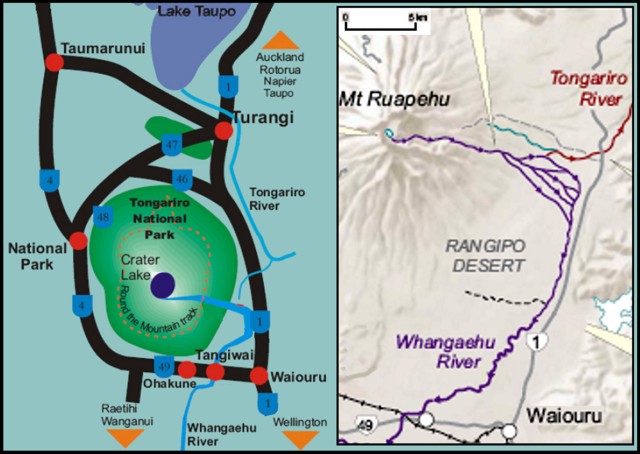
Lahar hazard. The last report on Ruapehu (BGVN 29:02) reviewed the government of New Zealand's efforts to lessen potential damage and loss of life from the possible collapse of the ash dam surrounding the lake that sits directly within the crater. An illustrative model of the most likely potential lahar was presented in the previous Bulletin (BGVN 29:02). Figure 27 provides more details on the regional geography.
According to IGNS and related government websites, the most likely lahar's path starts from a 7-m-thick tephra dam sitting above bedrock along the low point in Ruapehu's crater rim. This path descends along the Whangaehu valley, a drainage that initially travels radially down the cone to the E. Where the Whangaehu reaches beyond ~ 10 km from the rim (figure 27), the channel curves sharply S and then SW, ultimately crossing Ruapehu's S side. In contrast, just upstream of the above-mentioned bend, the intersecting Tongariro river flows N. At that connection between the two drainages (a divide), engineers added a 300-m-long embankment (a levee or bund), to keep substantial material from entering the Tongariro drainage. Engineers also added one or more chutes to direct some of the Whangaehu river S and away from the critical junction. Protecting the Tongariro river from sudden influx of water and debris protects infrastructure along and downstream of that river. For example, the Tongariro river enters Lake Taupo, a 30 x 40 km caldera lake. Lake Taupo drains to the N along the Waikato river and dams along that river generate hydroelectric power.
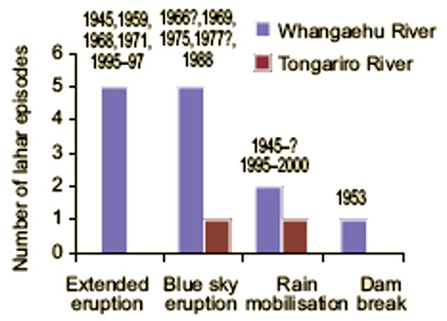
According to the Institute of Geological & Nuclear Sciences (IGNS), about 60 lahars have swept down the mountain's southern side in the past 150 years. Lahars are not limited to the Whangaehu valley as eruptive and mass wasting processes can result in sudden influx of water and debris in other drainages as well. Lahar episodes since 1945 appear on figure 28.
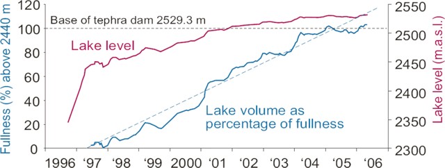
Figure 29 contains plots of the crater lake's surface elevation during the past several years. The plot is part of a poster available on the Department of Conservation website. The poster also notes the approximate volume of the crater lake, 107 m3. The tephra dam allows lake water to seep through it, considerably complicating estimates of the late-stage-filling rates, and any predicted date of overflow or related failure. Derek Cheng wrote an 8 January 2007 New Zealand Herald news piece stating that the lake then stood ~2.7 m below the dam's top. According to Chang's news story, the tephra dam allowed lake water to seep through it at a rate of ~10 L per second.
Crater Lake observations. Ruapehu's Crater Lake had warmed following periods of volcanic tremor, with heating cycles getting to temperatures ranging from about 15 to 40°C (eg., 39°C during February 2004 and ~36°C during late October 2006; table 13). The IGNS website notes that Ruapehu's heating cycles typically occur every 9-12 months and normally last 1-3 months.
An innovative approach to covering the current lahar hazard status can be found at the Department of Conservation website. As of early February 2007 the reports were "updated every 1-2 weeks depending on weather conditions and [field] site visits."
Reference. Keys, H.J.R., (date unknown), Lahars from Mount Ruapehu—mitigation and management; NZ Dept. of Conservation website (a poster conveyed as a PDF file; creation/publication date unknown) (URL: http://www.doc.govt.nz/templates/summary.aspx?id=42442).
Geological Summary. Ruapehu, one of New Zealand's most active volcanoes, is a complex stratovolcano constructed during at least four cone-building episodes dating back to about 200,000 years ago. The dominantly andesitic 110 km3 volcanic massif is elongated in a NNE-SSW direction and surrounded by another 100 km3 ring plain of volcaniclastic debris, including the NW-flank Murimoto debris-avalanche deposit. A series of subplinian eruptions took place between about 22,600 and 10,000 years ago, but pyroclastic flows have been infrequent. The broad summait area and flank contain at least six vents active during the Holocene. Frequent mild-to-moderate explosive eruptions have been recorded from the Te Wai a-Moe (Crater Lake) vent, and tephra characteristics suggest that the crater lake may have formed as recently as 3,000 years ago. Lahars resulting from phreatic eruptions at the summit crater lake are a hazard to a ski area on the upper flanks and lower river valleys.
Information Contacts: Institute of Geological & Nuclear Sciences (IGNS), Private Bag 2000, Wairakei, New Zealand (URL: http://www.gns.cri.nz/, https://www.geonet.org.nz/); New Zealand Department of Conservation, Private Bag, Turangi, New Zealand (URL: http://www.doc.govt.nz/).


