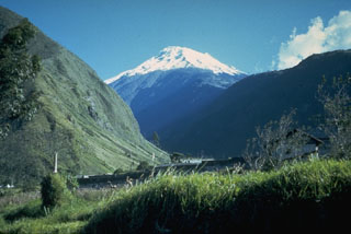
Report on Tungurahua (Ecuador) — April 2007
Bulletin of the Global Volcanism Network, vol. 32, no. 4 (April 2007)
Managing Editor: Richard Wunderman.
Tungurahua (Ecuador) Post-eruptive quiet spurs return of residents, but activity increases again in 2007
Please cite this report as:
Global Volcanism Program, 2007. Report on Tungurahua (Ecuador) (Wunderman, R., ed.). Bulletin of the Global Volcanism Network, 32:4. Smithsonian Institution. https://doi.org/10.5479/si.GVP.BGVN200704-352080
Tungurahua
Ecuador
1.467°S, 78.442°W; summit elev. 5023 m
All times are local (unless otherwise noted)
This report covers the time interval early January to 2 March 2007, based on Special Reports of the Ecuadorian Geophysical Institute (IG). This reporting interval was mainly one of relative quiet. In contrast, our previous report (BGVN 32:12), covered IG reports describing energetic eruptions of July and August 2006. Those IG reports also mentioned eruption-related fatalities and the discovery of a new growing bulge on the volcano's N flank. A map and geographic background were tabulated in BGVN 29:01.
Relative quiet prevails and some residents return. As touched on in BGVN 32:12, after August 2006, the volcanic vigor at Tungurahua was minimal and of low energy. The decrease in activity was gradual through mid-December 2006. The vigor remained low until mid-January 2007. Ash emissions did occur but were consistently minor.
IG reports noted that the relative tranquility at Tungurahua could reflect a pattern similar to that seen there in 1918. That was a case when various months of volcanic quiet occurred, only to be followed by explosive eruptions of large size. The latter generated pyroclastic flows.
During the quiet that followed the July and August 2006 eruptions, residents who had evacuated from the margins of the volcano returned to their properties. The IG noted that, unfortunately, these returning residents became more vulnerable to volcanic hazards and made emergency response more difficult.
Vigor increases. Between 20 January and 5 February 2007 internal seismic activity resumed, behavior consisting of a few earthquakes inferred as associated with fractures (volcano-tectonic earthquakes, VTs). On 13 February the volcano emitted an eruptive column with moderate ash content. After 19 February there was a reoccurrence of seismic VTs. These were of shorter duration but higher intensity than those that occurred during the previous period.
During 23-24 February 2007, volcanic tremors and seismic LP's were registered at the Volcanic Observatory of Tungurahua (VOT). At 0310 on 24 February, VOT staff and local observers reported continuous roars of moderate intensity, and discharge of incandescent material that both rose to ~ 800 m above the summit and descended ~ 1000 m down the volcano's flanks.
The emission column headed NW. Fine tephra fell, followed by a thick ashfall that was black in color. It left a deposit 3 mm thick in the towns of Pillate and San Juan. Reports received from Cotaló, Bilbao, Manzano, and Choglontús that indicate a thick, dark ashfall in those spots left a deposit 2 mm thick. Ashfall was also reported in the area of Quero.
Seismic activity decreased on 24 February as well as the intensity and frequency of the roars. As of 2 March, sporadic explosions of ash and incandescent material had been observed. Around this time some bad weather prevented clear views of the upper volcano; however, some reporters noted minor ashfall along the SW portion of the crater. Additionally, the SO2 flux increased to ~ 2,000 metric tons a day for the first time since the beginning of the year. The IG's "Seismic Activity Index" indicated an increase of the volcano's internal activity.
Two scenarios envisioned. Given the available data, the IG concluded that the volcano had received a new influx of magma. They proposed two potential scenarios: (1) the current levels of activity will continue and constant emissions of ash, (potentially more intense) will be generated. Ash clouds will be blown by winds that at this time of the year are predominantly westerly, with occasional S and NW variations. These ash clouds could generate heavy ashfall in the towns downwind from the volcano; or (2) the volume and speed of ascent of the magmatic gases originating from the new magma will increase dramatically, in which case, new explosive eruptions of pyroclastic flows similar to those on 14 July and 16 August could occur.
Geological Summary. Tungurahua, a steep-sided andesitic-dacitic stratovolcano that towers more than 3 km above its northern base, is one of Ecuador's most active volcanoes. Three major edifices have been sequentially constructed since the mid-Pleistocene over a basement of metamorphic rocks. Tungurahua II was built within the past 14,000 years following the collapse of the initial edifice. Tungurahua II collapsed about 3,000 years ago and produced a large debris-avalanche deposit to the west. The modern glacier-capped stratovolcano (Tungurahua III) was constructed within the landslide scarp. Historical eruptions have all originated from the summit crater, accompanied by strong explosions and sometimes by pyroclastic flows and lava flows that reached populated areas at the volcano's base. Prior to a long-term eruption beginning in 1999 that caused the temporary evacuation of the city of Baños at the foot of the volcano, the last major eruption had occurred from 1916 to 1918, although minor activity continued until 1925.
Information Contacts: Geophysical Institute (IG), Escuela Politécnica Nacional, Apartado 17-01-2759, Quito, Ecuador (URL: http://www.igepn.edu.ec/).

