Report on Nyiragongo (DR Congo) — August 2007
Bulletin of the Global Volcanism Network, vol. 32, no. 8 (August 2007)
Managing Editor: Richard Wunderman.
Nyiragongo (DR Congo) During 2007 the lava lake persists; one death; daily SO2 data stream begins
Please cite this report as:
Global Volcanism Program, 2007. Report on Nyiragongo (DR Congo) (Wunderman, R., ed.). Bulletin of the Global Volcanism Network, 32:8. Smithsonian Institution. https://doi.org/10.5479/si.GVP.BGVN200708-223030
Nyiragongo
DR Congo
1.52°S, 29.25°E; summit elev. 3470 m
All times are local (unless otherwise noted)
As has been the case since July 2002, nearly daily thermal anomalies detected by satellite instruments continued through August 2007, confirming the presence of a lava lake in the summit crater. These anomalies were acquired from MODIS satellites and are available on the University of Hawai'i Institute of Geophysics and Planetology (HIGP) MODIS Hotspot Alert website.
The Moderate Resolution Imaging Spectroradiometer (MODIS) aboard NASA's Terra satellite recorded a light-colored plume on 19 June 2007 that extended SE over Lake Kivu. NASA suggested that it consisted primarily of water vapor.
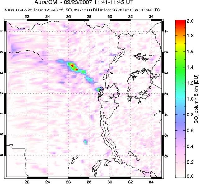
Almost daily SO2 concentration-pathlengths for Nyiragongo (figure 37) have been reported online starting in May 2007 by the OMI Sulfur Dioxide Group. The SO2 concentrations are spectroscopically determined primarily by the Ozone Monitoring Instrument (OMI) aboard NASA's Earth Observing System AURA spacecraft. The highest measured amounts were ~ 2.0 Dobson Units or greater on about 20 days during June-September 2007. A Dobson Unit, DU, the product of concentration and pathlength, is a function of the number of SO2 molecules in a unit area of the atmospheric column.
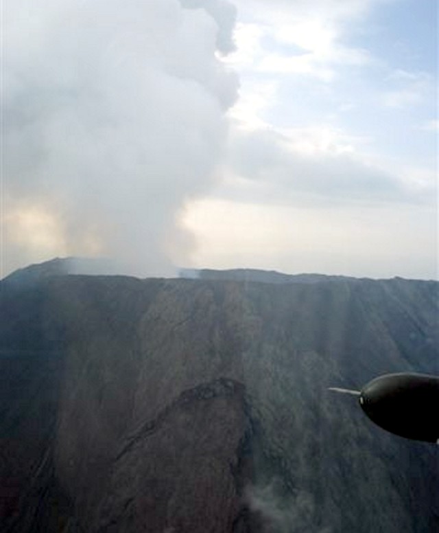
A photo of the summit taken from a fixed-wing aircraft in early July 2007 disclosed that a substantial portion of the outer crater wall on the W flank had collapsed, forming a large slump with an arcuate headwall (figure 38). The implication in the pilot report was that this was a recent event.
According to news media accounts, on 6 July 2007 a female Chinese tourist climbed over the crater rim of Nyiragongo for a photograph of the crater's interior. She slipped and fell more than 100 m down the steep wall of the crater to her death.
Geological Summary. The Nyiragongo stratovolcano contained a lava lake in its deep summit crater that was active for half a century before draining catastrophically through its outer flanks in 1977. The steep slopes contrast to the low profile of its neighboring shield volcano, Nyamuragira. Benches in the steep-walled, 1.2-km-wide summit crater mark levels of former lava lakes, which have been observed since the late-19th century. Two older stratovolcanoes, Baruta and Shaheru, are partially overlapped by Nyiragongo on the north and south. About 100 cones are located primarily along radial fissures south of Shaheru, east of the summit, and along a NE-SW zone extending as far as Lake Kivu. Many cones are buried by voluminous lava flows that extend long distances down the flanks, which is characterized by the eruption of foiditic rocks. The extremely fluid 1977 lava flows caused many fatalities, as did lava flows that inundated portions of the major city of Goma in January 2002.
Information Contacts: NASA Earth Observatory (URL: http://earthobservatory.nasa.gov); OMI Sulfur Dioxide Group, based in the Joint Center for Earth Systems Technology at the University of Maryland Baltimore County (UMBC), and atNASA Goddard Space Flight Center (URL: https://so2.gsfc.nasa.gov/); Hawai'i Institute of Geophysics and Planetology, MODIS Thermal Alert System, School of Ocean and Earth Sciences and Technology (SOEST), University of Hawai'i, 2525 Correa Road, Honolulu, HI, USA (URL: http://modis.higp.hawaii.edu/); Reuters (URL: http://www.reuters.com/); Agence France-Presse (URL: http://www.afp.com/); Sean O'Conner, ECHO (European Commission's Humanitarian Aid Office) Flight, Goma, Democratic Republic of Congo; Tom Pfeiffer, Volcano Discovery (URL: http://www.decadevolcano.net/).


