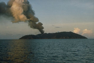
Report on Barren Island (India) — June 2008
Bulletin of the Global Volcanism Network, vol. 33, no. 6 (June 2008)
Managing Editor: Richard Wunderman.
Barren Island (India) Thermal anomalies and red glow indicate that a new eruption started in May 2008
Please cite this report as:
Global Volcanism Program, 2008. Report on Barren Island (India) (Wunderman, R., ed.). Bulletin of the Global Volcanism Network, 33:6. Smithsonian Institution. https://doi.org/10.5479/si.GVP.BGVN200806-260010
Barren Island
India
12.278°N, 93.858°E; summit elev. 354 m
All times are local (unless otherwise noted)
A scientific expedition in February 2008 observed that the morphology of the volcano had changed considerably since 2005. The eruption that began in May 2005 (BGVN 30:05) ejected lava and tephra that built a new scoria cone NE of the previous central cone. Lava flows covered all of the earlier flows, and several new spatter cones were formed. Fumarolic activity was continuing in February, with a large amount of steam from the central cone.
Activity seemingly decreased in late March 2006, as shown by a significant decline in the number and frequency of thermal anomalies (BGVN 32:07). However, intermittent anomalies continued until 5 October 2007, and ash plumes were seen in satellite imagery on 23 December 2007 (BGVN 33:02). Thermal anomalies detected by MODIS instruments began to be detected again on 12 May 2008 at 1935 (UTC), suggesting a renewal of eruptive activity. Anomalies continued to be identified on 19 days through the end of June.
During 15-30 June 2008 observers on an Indian Coast Guard patrol boat could see red glow from the central cone summit at night from a distance of about 10 km. There were also twelve earthquakes between 27 and 29 June, centered SW of Port Blair (140 km SW of Barren Island) in the Andaman Islands.
Geological Summary. Barren Island, a possession of India in the Andaman Sea about 135 km NE of Port Blair in the Andaman Islands, is the only historically active volcano along the N-S volcanic arc extending between Sumatra and Burma (Myanmar). It is the emergent summit of a volcano that rises from a depth of about 2250 m. The small, uninhabited 3-km-wide island contains a roughly 2-km-wide caldera with walls 250-350 m high. The caldera, which is open to the sea on the west, was created during a major explosive eruption in the late Pleistocene that produced pyroclastic-flow and -surge deposits. Historical eruptions have changed the morphology of the pyroclastic cone in the center of the caldera, and lava flows that fill much of the caldera floor have reached the sea along the western coast.
Information Contacts: Dornadula Chandrasekharam, Dept. Earth Sciences, Centre of Studies in Resources Engineering, Indian Institute of Technology Bombay, Mumbai 400076, India (URL: http://www.geos.iitb.ac.in/index.php/dc); Hawai'i Institute of Geophysics and Planetology (HIGP) Thermal Alerts System, School of Ocean and Earth Science and Technology (SOEST), Univ. of Hawai'i, 2525 Correa Road, Honolulu, HI 96822, USA (URL: http://modis.higp.hawaii.edu/).

