Report on Cleveland (United States) — July 2008
Bulletin of the Global Volcanism Network, vol. 33, no. 7 (July 2008)
Managing Editor: Richard Wunderman.
Cleveland (United States) Eruption on 21 July 2008; lava flows and ash plumes
Please cite this report as:
Global Volcanism Program, 2008. Report on Cleveland (United States) (Wunderman, R., ed.). Bulletin of the Global Volcanism Network, 33:7. Smithsonian Institution. https://doi.org/10.5479/si.GVP.BGVN200807-311240
Cleveland
United States
52.825°N, 169.944°W; summit elev. 1730 m
All times are local (unless otherwise noted)
Minor explosions were reported from Cleveland volcano on 15 and 29 February 2008 Cleveland (BGVN 33:02); such events have been typical during the last several years. This report discusses subsequent behavior and observations into late August, including thermal anomalies, explosions, ash plumes, and an inferred lava flow.
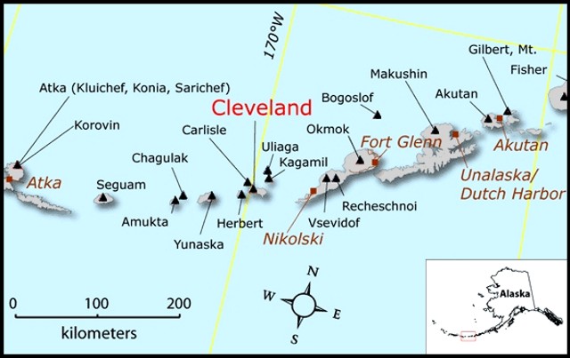
AVO noted that during the two weeks prior to 9 May 2008, an increasing number of thermal anomalies were visible on satellite imagery. On 7 May, a small ash plume rose to an altitude of below 4.6 km. Also, around the same time, a ship N of Nikolski on Umnak Island (~ 75 km ENE) reported receiving a dusting of ash (figure 6).
During June and early July 2008, satellite and webcam views were mostly obscured by clouds and fog, and AVO received no reports of eruptive activity. Satellite analysts noted a minor thermal anomaly on 8 June.
On 21 July, AVO raised the alert level/aviation color code for Cleveland to Watch/Orange based on reports from pilots and observers on fishing boats. Reports from fishing boats indicated that an eruption started at about 1200 and ash near sea level may have drifted NW. Pilots reported that an ash-and-steam plume rose to altitudes of ~ 4.6-5.2 km and drifted SE.
Satellite imagery for 22 July revealed a steam plume possibly containing some ash drifting more than 50 km ESE. It reached altitudes of 3-6 km. Thermal anomalies led analysts to infer a possible lava flow. Also, in harmony with this interpretation, on 22 July the MODVOLC algorithm registered its first alert thus far in 2008 (3 pixels) and near-daily alerts followed as late as 29 July (table 2).
Table 2. Thermal anomalies ("alerts") at Cleveland registered by the MODIS satellite as processed by the MODVOLC algorithm during the interval 1 January-9 September 2008. The only recent alerts during that interval were during the period of 22-29 July. Courtesy of Hawai'i Institute of Geophysics and Planetology (HIGP) Thermal Alerts System.
| Date (UTC) | Time (UTC) | Pixels | Satellite |
| 22 Jul 2008 | 1255 | 3 | Aqua |
| 23 Jul 2008 | 0010 | 3 | Aqua |
| 24 Jul 2008 | 0840 | 2 | Terra |
| 24 Jul 2008 | 1245 | 3 | Aqua |
| 24 Jul 2008 | 1420 | 5 | Aqua |
| 27 Jul 2008 | 1315 | 1 | Aqua |
| 27 Jul 2008 | 2240 | 1 | Terra |
| 29 Jul 2008 | 0855 | 1 | Terra |
AVO reported that satellite views were hindered on 23 July due to cloud cover. On 24 July, a low-level ash plume and a strong thermal anomaly were noted near the summit. This thermal anomaly again suggested the presence of an active lava flow. The MODIS measurements shown in table 2 for 24 July indicated several thermal anomalies to the W of the cone and pixels that are displaced downslope, E of the cone, several almost reaching the ocean. The thermal anomalies continued to be detected during 26-28 July, and possible ash plumes drifted SE, E, and NE at altitudes of 3-6.1 km during 27-29 July.
According to David Schneider of AVO, the MODVOLC algorithm has a higher trigger threshold than an analyst and MODVOLC also has fewer observations each day since it only uses MODIS satellite data. AVO uses MODIS, AVHRR, and GOES satellites to reduce the chance of missing thermal anomalies due to cloud cover. Both MODVOLC and AVO use mid-IR data (in the 3.0 to 3.5 micron range) to detect high temperature thermal anomalies.
AVO reported that thermal anomalies detected at Cleveland's summit by various satellites during 30 July-5 August 2008 also suggested the presence of an active lava flow. The anomaly on 30 July extended about 6-9 km. On 31 July, a diffuse plume drifted less than 20 km NE, N, and NW at an altitude of 6.1 km. The plume was seen from an airplane on 1 August.
On 5 August, thermal anomalies appeared on the W, S, and SE flanks. They possibly indicated the presence of pyroclastic flows or hot lahars. On 6 August 2008, AVO reported that the thermal anomalies noted at Cleveland's summit and on the W, S, and SE flanks had decreased in intensity since first noted on 21 July, indicating that the lava flows slowed or stopped. The hazard status was lowered to Yellow/Advisory. During 7-10 August 2008, a weak thermal anomaly at Cleveland's summit was intermittently visible when not obscured by clouds and drifting ash from Kasatochi (~ 390 km WSW).
On 11 August, thermal anomalies on satellite imagery again indicated that lava flowed down the flanks. On 12 August an ash plume rose to an altitude of 7.6 km and drifted 100 km SW. Cloud cover prevented satellite observations during 13-26 August, although a possible thermal anomaly was present on 24 August. On 11 August the hazard status rose to Orange/Watch, but on 25 August it dropped to Yellow/Advisory.
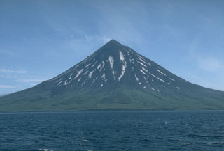
Geological Summary. The beautifully symmetrical Mount Cleveland stratovolcano is situated at the western end of the uninhabited Chuginadak Island. It lies SE across Carlisle Pass strait from Carlisle volcano and NE across Chuginadak Pass strait from Herbert volcano. Joined to the rest of Chuginadak Island by a low isthmus, Cleveland is the highest of the Islands of the Four Mountains group and is one of the most active of the Aleutian Islands. The native name, Chuginadak, refers to the Aleut goddess of fire, who was thought to reside on the volcano. Numerous large lava flows descend the steep-sided flanks. It is possible that some 18th-to-19th century eruptions attributed to Carlisle should be ascribed to Cleveland (Miller et al., 1998). In 1944 it produced the only known fatality from an Aleutian eruption. Recent eruptions have been characterized by short-lived explosive ash emissions, at times accompanied by lava fountaining and lava flows down the flanks.
Information Contacts: Alaska Volcano Observatory (AVO), a cooperative program of the U.S. Geological Survey, 4200 University Drive, Anchorage, AK 99508-4667, USA (URL: http://www.avo.alaska.edu/), the Geophysical Institute, University of Alaska, PO Box 757320, Fairbanks, AK 99775-7320, USA, and the Alaska Division of Geological and Geophysical Surveys, 794 University Ave., Suite 200, Fairbanks, AK 99709, USA; Hawai'i Institute of Geophysics and Planetology (HIGP) Thermal Alerts System, School of Ocean and Earth Science and Technology (SOEST), Univ. of Hawai'i, 2525 Correa Road, Honolulu, HI 96822, USA (URL: http://modis.higp.hawaii.edu/).


