Report on Galeras (Colombia) — November 2008
Bulletin of the Global Volcanism Network, vol. 33, no. 11 (November 2008)
Managing Editor: Richard Wunderman.
Galeras (Colombia) Ash plumes and thermal alerts continue into late 2008
Please cite this report as:
Global Volcanism Program, 2008. Report on Galeras (Colombia) (Wunderman, R., ed.). Bulletin of the Global Volcanism Network, 33:11. Smithsonian Institution. https://doi.org/10.5479/si.GVP.BGVN200811-351080
Galeras
Colombia
1.22°N, 77.37°W; summit elev. 4276 m
All times are local (unless otherwise noted)
The most recent report on Galeras (BGVN 33:03) discussed activity between September 2006 and April 2008 that included a number of minor earthquakes and plumes (mostly ash) that rose generally between 4.4 and 7.2 km in altitude. One eruption during that interval sent a plume up to 11 km altitude. In early April 2008, seismicity decreased. This report reviews September through 9 December 2008.
According to the Instituto Colombiano de Geologia y Mineria (INGEOMINAS) seismic activity at Galeras was low during April through August 2008, although a few small earthquakes occurred and emissions of steam, sometimes mixed with ash, were frequent. Some emission clouds reached greater than 1 km above the summit. Sulfur dioxide (SO2) levels were moderate, sometimes ranging above 8,000 tons per day. On 21 July, SO2 levels reached 10,800 tons per day.
The INGEOMINAS reported that an M 2 earthquake located S of Galeras occurred on 9 September at a depth of less than 1 km. Seismicity in September was dominated by long-period and tremor events (table 9). The SO2 emission rate fluctuated between 3,200 and 6,800 tons during 11-16 September, but jumped to 14,500 tons on the day after the earthquake. Gas plumes drifted W and NW.
Table 9. Seismic events at Galeras in September 2008. Courtesy of INGEOMINAS.
| Week | Long-period | Hybrid | Volcano-tectonic | Tremor | Other |
| 01 Sep-07 Sep 2008 | 116 | 0 | 6 | 138 | 2124 |
| 08 Sep-14 Sep 2008 | 75 | 2 | 7 | 51 | 1572 |
| 15 Sep-21 Sep 2008 | 78 | 11 | 12 | 108 | 1718 |
| 22 Sep-28 Sep 2008 | 146 | 9 | 8 | 234 | 1681 |
| 29 Sep-05 Oct 2008 | 144 | 5 | 7 | 366 | 1580 |
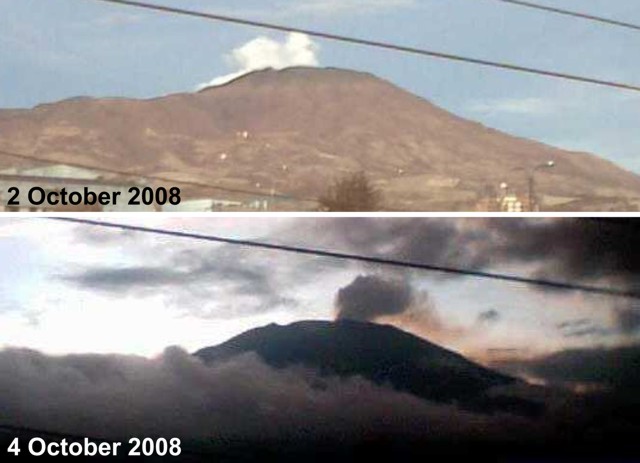
A 19 September overflight revealed incandescence coming from the main crater. Thermal images revealed that parts of the cone in the main crater measured 550°C; other anomalies on the cone's flanks measured 270°C. SO2 fluxes were near 8,200 tons per day. Further measurements during 19-23 September revealed temperatures between 500 and 600°C and SO2 fluxes between 3,000 and 5,200 tons per day. Gas emissions could be seen from the city of San Juan de Pasto on 2 and 4 October 2008 (figure 112).
 |
Figure 112. Photos of gas emissions from Galeras taken from the city of San Juan de Pasto on 2 and 4 October 2008. Courtesy of INGEOMINAS. |
According to INGEOMINAS, during the latter half of October and first week of November, white plumes (occasionally tinged gray or blue) rose from Galeras to altitudes of 4.5-7.4 km and drifted S, NW, and W. On 20 October, an M 2.3 earthquake located 600 m SSW of the main crater occurred at a depth of less than 1 km. During an overflight on 30 October, incandescence was observed on some parts of the lava dome.
On 11 November, INGEOMINAS reported that during the previous week, pulsating white plumes, occasionally tinged gray, rose to altitudes of 4.5-5.7 km and drifted W. On 30 November, ash emissions from Galeras were associated with seismic tremor that lasted about 30 minutes. The resultant ash plumes drifted 6-12.5 km S and SSW.
During an overflight on 11 December, thermal images of the lava dome in Galeras's crater were taken. The images revealed temperatures as hot as 530°C on the N side of the dome and near 80°C on the W side. Temperatures had declined compared to thermal images taken in October 2008. On 16 December, INGEOMINAS reported that during the previous few days, gas plumes rose to altitudes of 5.9-6.7 km and drifted NW.
During October, November, and December low seismicity and moderate gas emissions continued. Maximum SO2 emissions ranged from 780 to 5,300 tons per day.
MODVOLC. During 2008, MODVOLC registered several thermal alerts on Galeras's summit to NE sides (table 10). The MODVOLC thermal imaging system uses Modis instruments on the Aqua and Terra satellites. The MODVOLC thermal alert prior to those on table 10 took place on 30 December 2005.
Table 10. Thermal anomalies at Galeras based on MODVOLC imaging between 1 April and 4 December 2008 (continued from the list in BGVN 33:03). Courtesy of Hawai'i Institute of Geophysics and Planetology (HIGP) Thermal Alerts System.
| Date (UTC) | Time (UTC) | Pixels | Satellite |
| 05 Aug 2008 | 0350 | 1 | Terra |
| 05 Aug 2008 | 0645 | 2 | Aqua |
| 13 Sep 2008 | 0655 | 1 | Aqua |
| 24 Sep 2008 | 0340 | 1 | Terra |
| 24 Sep 2008 | 0635 | 1 | Aqua |
| 04 Dec 2008 | 0645 | 1 | Aqua |
As of 9 December, the level of activity of the volcano remained at 3 (Yellow), signifying that "changes in the behavior of volcanic activity have been noted." (Note: On the established local scale, Alert Level 1 is highest state of alert.)
Geological Summary. Galeras, a stratovolcano with a large breached caldera located immediately west of the city of Pasto, is one of Colombia's most frequently active volcanoes. The dominantly andesitic complex has been active for more than 1 million years, and two major caldera collapse eruptions took place during the late Pleistocene. Long-term extensive hydrothermal alteration has contributed to large-scale edifice collapse on at least three occasions, producing debris avalanches that swept to the west and left a large open caldera inside which the modern cone has been constructed. Major explosive eruptions since the mid-Holocene have produced widespread tephra deposits and pyroclastic flows that swept all but the southern flanks. A central cone slightly lower than the caldera rim has been the site of numerous small-to-moderate eruptions since the time of the Spanish conquistadors.
Information Contacts: Instituto Colombiano de Geología y Minería (INGEOMINAS), Observatorio Vulcanológico y Sismológico de Popayán, Popayán, Colombia; Hawai'i Institute of Geophysics and Planetology (HIGP) Thermal Alerts System, School of Ocean and Earth Science and Technology (SOEST), Univ. of Hawai'i, 2525 Correa Road, Honolulu, HI 96822, USA (URL: http://modis.higp.hawaii.edu/).

