Report on Ambrym (Vanuatu) — January 2009
Bulletin of the Global Volcanism Network, vol. 34, no. 1 (January 2009)
Managing Editor: Richard Wunderman.
Ambrym (Vanuatu) Lava lakes at least intermittently active during 2006 into 2009
Please cite this report as:
Global Volcanism Program, 2009. Report on Ambrym (Vanuatu) (Wunderman, R., ed.). Bulletin of the Global Volcanism Network, 34:1. Smithsonian Institution. https://doi.org/10.5479/si.GVP.BGVN200901-257040
Ambrym
Vanuatu
16.25°S, 168.12°E; summit elev. 1334 m
All times are local (unless otherwise noted)
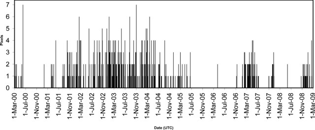
Thermal anomalies detected by MODIS instruments and processed by MODVOLC indicated that lava lakes in both summit craters at Ambrym have been at least intermittently active during November 2006 through February 2009 (figure 18). After MODVOLC alerts were detected on 8 and 15 November 2006 (BGVN32:05), they were again frequently identified from 12 January until 11 July 2007. Another cluster occurred between 31 October and 27 December 2007. A single alert occurred on 23 May 2008. Alerts resumed again on 21 October 2008 and continued through 15 February 2009.
Observations during 31 August-8 September 2008.Arnold Binas reached the summit and observed lava lake activity during 31 August-8 September 2008, an interval without thermal alerts. Binas also reported that the lake was largely crusted over, abundant steam was emitted, and poor weather conditions often prevented views into the craters. Such factors may have prevented satellite detection of low-level activity during those, and possibly other, times.
Binas climbed to the Benbow crater rim once, but thick steam prevented visual observation of the inner cone; however, strong degassing was noted, often in pulses. At Marum, low rain clouds on the SE side limited observations to periods of a few seconds at a time.
The Marum cone has three active sub-craters with distinct names. The name Mbwelesu describes the main crater; Niri Mbwelesu, a secondary crater close to Mbwelesu's rim; and Mbogon Niri Mbwelesu, a small collapse-pit to the S of Niri Mbwelesu. (The collapse pit Mbogon Niri Mbwelesu is also sometimes called Niri Mbwelesu Taten.)
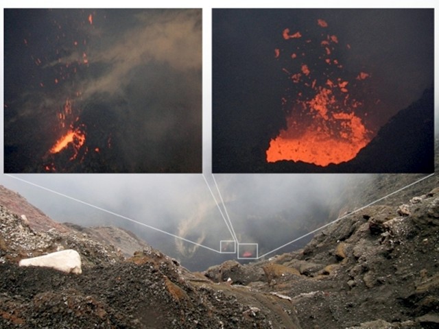
During the visit, partial views into the Mbwelesu crater were rare through small gaps in constant rain clouds and strong steam emissions. A small lava lake was visible in the main vent, and another nearby opening often spattered small chunks of lava (figure 19). It appeared that both openings were holes through a crusted-over lava lake. The width of the visible portion of the larger opening, measured in digital image pixels at a given focal length and an assumed distance of 350-400 m, was determined to be on the order of 7.5-8.5 m. Waves rolled back and forth along the surface of the covered lake almost constantly, splashing lava through the holes, to a maximum height of about 30-35 m. Degassing also caused small explosions. Noises from the lava lake could be heard throughout the night from within the tent ~ 15 m from the crater rim, despite strong winds and rain.
Strong gas emissions took place in Niri Mbwelesu, with only very rare views of the crater floor, on which a small lake of brownish water was present next to a steaming vent. Mbogon Niri Mbwelesu displayed mostly strong but silent gas emissions from fumaroles on the crater floor, occasionally clearing enough to enable views of the bottom. Sometimes small rockfalls were heard, but not seen, inside the crater.
Geological Summary. Ambrym, a large basaltic volcano with a 12-km-wide caldera, is one of the most active volcanoes of the New Hebrides Arc. A thick, almost exclusively pyroclastic sequence, initially dacitic then basaltic, overlies lava flows of a pre-caldera shield volcano. The caldera was formed during a major Plinian eruption with dacitic pyroclastic flows about 1,900 years ago. Post-caldera eruptions, primarily from Marum and Benbow cones, have partially filled the caldera floor and produced lava flows that ponded on the floor or overflowed through gaps in the caldera rim. Post-caldera eruptions have also formed a series of scoria cones and maars along a fissure system oriented ENE-WSW. Eruptions have apparently occurred almost yearly during historical time from cones within the caldera or from flank vents. However, from 1850 to 1950, reporting was mostly limited to extra-caldera eruptions that would have affected local populations.
Information Contacts: Hawai'i Institute of Geophysics and Planetology (HIGP) Thermal Alerts System, School of Ocean and Earth Science and Technology (SOEST), Univ. of Hawai'i, 2525 Correa Road, Honolulu, HI 96822, USA (URL: http://modis.higp.hawaii.edu/); Arnold Binas, Toronto, Canada (URL: http://www.summitpost.org/user_page.php?user_id=42443, http://www.flickr.com/photos/hshdude/collections/72157600584144439/).


