Report on Soufriere Hills (United Kingdom) — October 2009
Bulletin of the Global Volcanism Network, vol. 34, no. 10 (October 2009)
Managing Editor: Richard Wunderman.
Soufriere Hills (United Kingdom) A lull during late 2008 and intermittent high activity during late 2009
Please cite this report as:
Global Volcanism Program, 2009. Report on Soufriere Hills (United Kingdom) (Wunderman, R., ed.). Bulletin of the Global Volcanism Network, 34:10. Smithsonian Institution. https://doi.org/10.5479/si.GVP.BGVN200910-360050
Soufriere Hills
United Kingdom
16.72°N, 62.18°W; summit elev. 915 m
All times are local (unless otherwise noted)
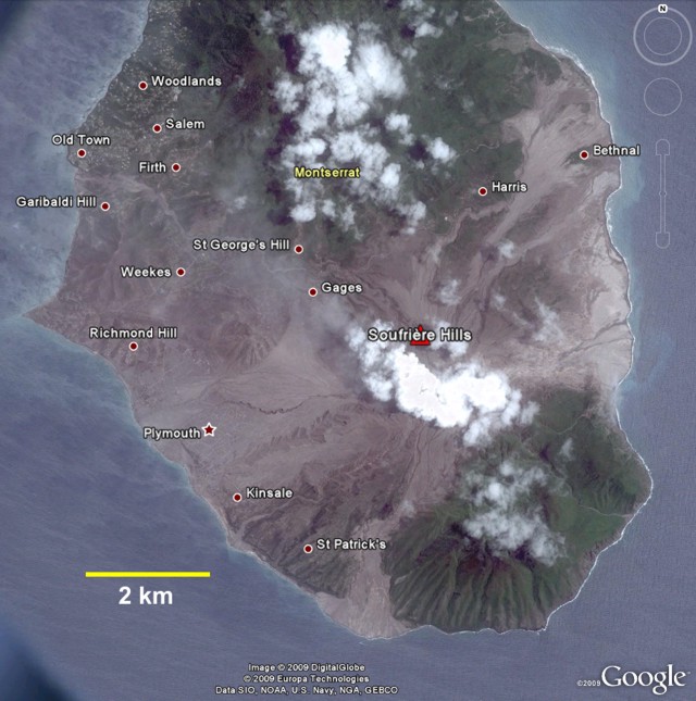
Dome collapse at Soufrière Hills (figure 79) and an eruption on 28 July 2008 was followed by dome regrowth (BGVN 33:10). During October through 4 December 2008, low-level activity included occasional earthquakes and explosion, lahars, and small pyroclastic flows. The current report describes activity from 5 December 2008 through 10 December 2009, primarily based on information provided by the Montserrat Volcano Observatory (MVO). Activity was intermittent during 2009 (table 68), with high-level activity resuming in November and continuing through at least 11 December.
 |
Figure 79. Visible satellite imagery showing Soufrière Hills and the southern part of Montserrat on 24 June 2006. Courtesy of Google Earth, with data provided by Europa Technologies and DigitalGlobe. |
Table 68. Ash plumes or plumes that may have contained ash from Soufrière Hills between 5 December 2008 and 2 December 2009. Courtesy Washington Volcanic Ash Advisory Center (VAAC), based on analysis of satellite imagery, information from MVO, and pilot reports.
| Date | Ash plume height, flow direction | Remarks |
| 13 Dec 2008 | 4.6-5.2 km | -- |
| 14 Dec 2008 | 1.8 km, W | -- |
| 15 Dec 2008 | 2.4-3 km, SW | -- |
| 16 Dec 2008 | S | Thermal anomaly |
| 19-23 Dec 2008 | 4.3 km, various | Thermal anomalies on 19 and 21 Dec |
| 24 Dec 2008 | 3 km | Caused by pyroclastic flow |
| 26-30 Dec 2008 | 2.1-4.9 km, various (28 and 30 Dec) | Thermal anomalies on 27 Dec |
| 03 Jan 2009 | 2.4-10.7 km, various | -- |
| 04 Jan 2009 | W, WSW | -- |
| 25 Feb 2009 | W | Caused by pyroclastic flow |
| 06 Apr 2009 | 2.7-4.9 km, NW | -- |
| 24 May 2009 | -- | Caused by pyroclastic flow |
| 04-06 Oct 2009 | 3.4-5.5 km, W, WNW | -- |
| 23-25 Oct 2009 | W | Caused by pyroclastic flows |
| 24 Nov 2009 | 6.1 km | Caused by pyroclastic flows |
| 02 Dec 2009 | 4.6-6.1 km | Caused by pyroclastic flows |
Activity during December 2008. Subsequent to the four explosions between 2-5 December 2008, the MVO reported that seismicity from the lava dome remained elevated. The volcano continued to inflate and discharge lava and ash during December 2008. Frequent pulses of ash rose from multiple places on the NW face of the lava dome and from a low on the dome behind Gages Mountain (as seen from Salem). A series of pyroclastic flows and rockfalls descended the Gages Valley and other valleys during December 2008, at least two reaching Plymouth (~ 5 km W). Significant lava dome growth on the SW flank was observed. Photographs showed that most of the growth had taken place since 8 December; lava was filling in the area between the lava dome and Chance's Peak. Initial calculations suggested that the dome grew at a rate of 1 m3/s during this time.
During the last two weeks of December 2008, the lava dome was characterized by increased lava extrusion, rockfalls, and pyroclastic flows. Lava extrusion on the N, W, and SW sides of the dome continued and incandescence on the dome was visible at night when weather was favorable. On 22 December, the Hazard Level was increased to 4 (on a scale 1-5) due to the repeated occurrences of pyroclastic flows in the lower part of Tyers Ghaut.
On 24 December, a large pyroclastic flow that reached Plymouth, and possibly the sea, generated an ash plume that rose to an altitude of 3 km. Ashfall was reported in areas 6-7 km NW. Large incandescent blocks, deposited by rockfalls and pyroclastic flows, were visible on multiple occasions at night in the lower parts of Tyers Ghaut. Fires triggered by surges were visible in the neighboring valley.
Activity during January-May 2009. On 2-3 January 2009, activity from the lava dome increased drastically. On 2 January, an energetic pyroclastic flow and associated surge traveled down Tyers Ghaut (NW) and reached the upper part of Belham River. On 3 January, after a period of elevated seismicity, two explosions produced large ash plumes that rose to altitudes greater than 10.7 km. Ashfall affected most of the island at elevations of 1.2 km and above. The explosions had significant "jet components" that rose to at least 500 m above the dome. In-column collapses resulted in pyroclastic flows that traveled W and reached Plymouth (~ 5 km W). According to news articles, about 70 people were evacuated from an area about 6-8 km NW.
According to MVO, the level of seismic activity decreased dramatically after 3 January. It increased slightly in early February, with occasional rockfalls, and several small pyroclastic flows. On 19 February 2009, the Hazard Level was lowered to 3. Seismic activity remained low during March through May. Occasionally, lahars caused by heavy rainfall descended through multiple river valleys. Thermal images of a pyroclastic flow on 25 February 2009, and other videos, can be viewed on the MVO YouTube channel (http://www.youtube.com/user/montserratvolcanoobs).
In mid-May 2009, activity from the Soufrière Hills lava dome increased slightly, but generally remained at a low level. Tectonic earthquakes were noted on 16, 18, 20, and 21 May at depths less than 3 km beneath the lava dome. Two possible explosions were detected on 21 May. The second and larger signal was followed by an ash plume that drifted W over Gages Mountain. During 21-22 May, a strong smell of sulfur dioxide was noted from Salem (6 km NW) to Woodlands (1 km N of Salem). Heavy rainfall caused erosion of the lava dome and hot pyroclastic flow deposits; steam plumes occasionally laden with ash occurred periodically from the base of Tyre's ghaut. Lahars traveled down multiple river valleys on 18 May.
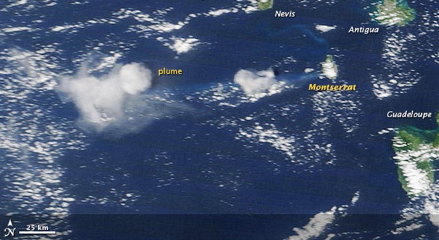
Activity during May-December 2009. Between the latter part of May and 4 October 2009, activity remained low with only periodic rockfalls and small pyroclastic flows. On 4 October 2009, a short volcano-tectonic earthquake swarm from the Soufrière Hills lava dome was detected. A period of tremor and vigorous ash venting followed about an hour later. The resulting ash plume drifted WNW across the island and out to sea, causing ashfall in Old Towne and Olveston. The seismic signals indicated no explosive activity or pyroclastic flows, but only two rockfalls after the ash-venting event. On 5 October, intermittent ash venting continued (figure 80), and ash fell S of inhabited areas. Early on 7 October, the ash-venting events from the lava dome ceased after a total of 13 had occurred. The last three were associated with small pyroclastic flows that traveled about 500 m down Tyers Ghaut to the NNW.
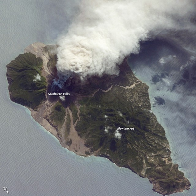
By mid-October 2009, activity from the Soufrière Hills lava dome rose to a high level. A new lava dome, first reported on 9 October, continued to grow. The new lava dome summit was about 60 m above the old dome structure. Seismicity was high and cycles of low-level tremor occurred at regular intervals. Over 1,200 rockfalls were detected and pyroclastic flows traveled down every major drainage valley except the Tar River valley to the E, resulting in ash plumes (figure 81). Heavy rainfall caused a lahar in the Belham Valley to the NW on 14 October. On 16 October, several large pyroclastic flows descended the White River to the S and reached the sea. Moderate-sized pyroclastic flows traveled 3 km NE down Tuitts Ghaut and White Bottom Ghaut, and a few smaller pyroclastic flows descended Tyers Ghaut to the N. Extensive ash clouds rose to an altitude of 6 km and drifted WNW, resulting in multiple minor ashfall in inhabited areas. Venting on 6 October 2009 can be seen on the YouTube channel for the Government Information Unit of Montserrat (http://www.youtube.com/user/GIUGOV). Lahars traveled NW down the Belham valley.
During the last week of October 2009, seismicity decreased slightly. However, numerous pyroclastic flows, some of which produced ash plumes, occurred in most of the major drainage valleys. Rockfalls were concentrated in the S. Heavy rainfall continued to cause lahars in the Belham Valley. On 29 October, a 40-m-high spine was seen protruding from the summit. Changes in lava-dome morphology seen on 30 October, and occurrences of pyroclastic flows traveling NE, indicated that growth was concentrated in the central part of the lava dome.
By 30 October, activity was again at a high level. Hybrid earthquakes were recorded for the first time since the renewal of activity in early October. Numerous pyroclastic flows occurred in most of the major drainage valleys. The frequency of pyroclastic flows increased on 5 November and particularly vigorous flows occurred in Tuitt's Ghaut to the NE. Ash fell in inhabited areas on a few occasions. Lahars descended the Belham Valley several times. Good views of the lava dome on 9 and 10 November revealed that recent lava-dome growth was concentrated on the WSW side, immediately NE of Chances Peak; intense incandescence and rockfalls were noted at night. Ash fell across the Montserrat on 11 November, and about 6-8 km NW in Salem, Old Towne, Olveston, and Woodlands on 12 November. One pyroclastic flow nearly reached the sea at Kinsale village (WSW).
By mid-November, activity from the Soufrière Hills lava dome consisted of ash venting along with semi-continuous rockfalls and pyroclastic flows that were concentrated on the W flank. Ashfall occurred across many areas of the island. On 19 November, heavy ashfall occurred to the NW between Old Towne and Brades. Views of the lava dome on 16 November showed that the dome height had decreased because of collapses and that a deep channel had developed NE of Chances Peak. Pyroclastic flows in the Gages Valley (W) continued down Spring Ghaut and Aymer's Ghaut, and spread onto the alluvial fan below St. Georges Hill.
On 21 November 2009, activity returned to a high level. Periods of tremor were detected on 23 November. Lava extrusion during this period shifted from the W side of the lava dome to the summit region. As a result, abundant pyroclastic flows traveled NE down Tuitt's Ghaut on 23 November for the first time in several weeks. On 24 November there was a period of 120 minutes of continuous pyroclastic flow activity, followed by 90 minutes of semi-continuous activity. The pyroclastic flows traveled W down Gages Valley and into Spring Ghaut, and NE down Tuitt's Ghaut and Whites Bottom Ghaut reaching Tuitt's village. Associated ash plumes rose to an altitude of 6.1 km. On 26 November, a pyroclastic flow that descended the Tar River valley was caused by collapse of part of the old, pre-2009 lava dome. Ashfall occurred in Old Towne and parts of Olveston. Incandescent material seen in a photograph taken at night on 29 November traveled down the flanks of the lava dome in several areas.
High-level activity from the lava dome continued through the first half of December 2009. Dome growth was concentrated on the N side, which has led to approximately 100 m of lateral growth of the lava dome in a northward direction. This growth has increased the available material for the formation of pyroclastic flows. Pyroclastic flows down the N flank became more abundant and their runout distance steadily increased. Pyroclastic flows also occurred to the NE and W, and one reached within 200 m of the sea. Ash vented from the S part of the lava dome.
On 10 December 2009, a large pyroclastic flow traveled down Tyers Ghaut. This pyroclastic flow reached to below the west end of Lees village in the Dyers river, some 3.5 km from the lava dome. This event prompted MVO to raise the Hazard Level from 3 to 4. The higher Hazard Level signifies that larger pyroclastic flows moving down the Belham valley are a more likely possibility. According to MVO, larger pyroclastic flows could be formed by a partial dome collapse which could involve several million cubic meters of material. Helicopter observations have shown that the head of Tuitt's Ghaut down to the junction with Whites Bottom Ghaut is full of pyroclastic flow deposits such that there is now a continuous surface across from Farrell's plain. The head of Tyers Ghaut is also now nearly full. This means that future pyroclastic flows are likely to be less confined by topography and will spread more readily across the N flanks of the volcano.
Thermal anomalies. MODIS satellite imagery recorded many thermal anomalies during December 2008, a smaller number in January 2009, none in February 2009, one in March 2009, and none during April through 10 October 2009. Beginning on 11 October through 11 December 2009, MODIS recorded a large number of thermal anomalies.
Geological Summary. The complex, dominantly andesitic Soufrière Hills volcano occupies the southern half of the island of Montserrat. The summit area consists primarily of a series of lava domes emplaced along an ESE-trending zone. The volcano is flanked by Pleistocene complexes to the north and south. English's Crater, a 1-km-wide crater breached widely to the east by edifice collapse, was formed about 2000 years ago as a result of the youngest of several collapse events producing submarine debris-avalanche deposits. Block-and-ash flow and surge deposits associated with dome growth predominate in flank deposits, including those from an eruption that likely preceded the 1632 CE settlement of the island, allowing cultivation on recently devegetated land to near the summit. Non-eruptive seismic swarms occurred at 30-year intervals in the 20th century, but no historical eruptions were recorded until 1995. Long-term small-to-moderate ash eruptions beginning in that year were later accompanied by lava-dome growth and pyroclastic flows that forced evacuation of the southern half of the island and ultimately destroyed the capital city of Plymouth, causing major social and economic disruption.
Information Contacts: Montserrat Volcano Observatory (MVO), Fleming, Montserrat, West Indies (URL: http://www.mvo.ms/); Washington Volcanic Ash Advisory Center, Satellite Analysis Branch (SAB), NOAA/NESDIS E/SP23, NOAA Science Center Room 401, 5200 Auth Rd, Camp Springs, MD 20746, USA (URL: http://www.ospo.noaa.gov/Products/atmosphere/vaac/); NASA Earth Observatory (URL: http://earthobservatory.nasa.gov/); Hawai'i Institute of Geophysics and Planetology (HIGP) Thermal Alerts System, School of Ocean and Earth Science and Technology (SOEST), Univ. of Hawai'i, 2525 Correa Road, Honolulu, HI 96822, USA (URL: http://modis.higp.hawaii.edu/); U.S. Air Force Weather Agency (AFWA)/XOGM, Offutt Air Force Base, NE 68113, USA.


