Report on Manam (Papua New Guinea) — February 2011
Bulletin of the Global Volcanism Network, vol. 36, no. 1 (February 2011)
Managing Editor: Richard Wunderman.
Edited by Jen Fela.
Manam (Papua New Guinea) Ashfall, pyroclastic flows, and seismicity in late December 2010
Please cite this report as:
Global Volcanism Program, 2011. Report on Manam (Papua New Guinea) (Fela, J., and Wunderman, R., eds.). Bulletin of the Global Volcanism Network, 36:1. Smithsonian Institution. https://doi.org/10.5479/si.GVP.BGVN201102-251020
Manam
Papua New Guinea
4.08°S, 145.037°E; summit elev. 1807 m
All times are local (unless otherwise noted)
This report discusses Manam behavior during November 2010 to early 2011. As previously reported, during August-October 2010, lava fragments and ash plumes rose from Manam (BGVN 35:09). Similar activity continued through at least 4 January 2011. Over 10,000 former island residents remain in care centers on the mainland (see below).
During the reporting period, the Rabaul Volcano Observatory (RVO) reported that the Main Crater produced mostly white plumes that were occasionally laden with ash. Incandescent material was ejected at times and mainly fell back in and around the crater, but occasionally spilled into the SE and SW valleys.
Based on analysis of satellite imagery, the Darwin Volcanic Ash Advisory Centre (VAAC) reported that ash plumes during 14-16 November 2010 rose to an altitude of 2.7 km and drifted ~95 km NW.
RVO reported that light brown to dark gray ash plumes rose 400-500 m above the South Crater during late November. People living on the island reported occasional roaring and rumbling noises. A new episode of eruptive activity began at South Crater on 25 December and was characterized during 25-29 December by rising ash plumes and ejections of incandescent lava fragments. Electronic tilt measurements showed a strong inflationary trend during 24-26 December but this slowed down on 26 December.
On 30 December 2010, activity from South Crater increased and was reported by observers in Bogia (on the mainland 20 km SSW). A dense ash plume rose 3 km above the summit crater and drifted NW, causing light ashfall in Tabele (4 km SW of Manam). An observer at Tabele confirmed the eruption and also reported that three pyroclastic flows descended the SE valley, stopping within a few to several hundred meters from the coastline. The first and largest pyroclastic flow devastated a broad unpopulated area between Warisi (E of Manam) and Dugulava (S of Manam) villages. RVO increased the Alert Level to Stage 3. Later that day, both ash emissions and the ejection of incandescent fragments diminished.
During early January 2011, plumes, sometimes containing ash, continued to rise above the South and Main Craters. RVO reported low roaring from the South Crater and incandescence was reported at times. On 8 January, the Alert Level was lowered from Stage 3 to Stage 2.
Seismicity and MODVOLC thermal alerts. Seismic data were not available during late November because of technical problems. Seismicity was low on 24 December, increased slightly after 25 December, then reached a point after 27 December where it fluctuated at and above moderate level. RVO reported seismicity during early January 2011 to be at a moderately low to moderate level.
Between 16 October 2010 and 10 January 2011, MODVOLC detected thermal anomalies on 25 days, mostly during late November and December. After 10 January, no thermal anomalies were detected through at least 16 February.
Multi-year evacuation. The UN's IRIN (Integrated Regional Information Networks) discussed Manam evacuees in reports issued 5 May and 20 December 2010. The 5 May 2010 report stated that "Around 14,000 islanders have been living in three care centres in the mainland province of Madang since November 2004. In March 2010 there was discussion that the displaced persons might be allowed to voluntarily return home to Manam Island."
According to the report, "A July 2009 assessment by the National Disaster Centre, the UN, and Oxfam concluded that living on the island was not a viable option because of a lack of access to arable land and public services, and the risk of further volcanic activity."
"The decision to begin returning residents was taken following heightened tensions between islanders and local residents (they speak the same language), largely over land issues. With little to no assistance, many of the IDPs rely on local gardening as their only source of food and livelihood, meaning they often encroach on nearby land.
"In March 2010, the National Executive Council (NEC) approved the establishment of the Manam Task Force Committee to manage the needs of the displaced islanders, with the primary goal of finding a suitable location for their permanent relocation."
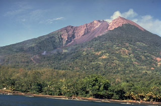
Geological Summary. The 10-km-wide island of Manam, lying 13 km off the northern coast of mainland Papua New Guinea, is one of the country's most active volcanoes. Four large radial valleys extend from the unvegetated summit of the conical basaltic-andesitic stratovolcano to its lower flanks. These valleys channel lava flows and pyroclastic avalanches that have sometimes reached the coast. Five small satellitic centers are located near the island's shoreline on the northern, southern, and western sides. Two summit craters are present; both are active, although most observed eruptions have originated from the southern crater, concentrating eruptive products during much of the past century into the SE valley. Frequent eruptions, typically of mild-to-moderate scale, have been recorded since 1616. Occasional larger eruptions have produced pyroclastic flows and lava flows that reached flat-lying coastal areas and entered the sea, sometimes impacting populated areas.
Information Contacts: Rabaul Volcano Observatory (RVO), PO Box 386, Rabaul, Papua New Guinea; Darwin Volcanic Ash Advisory Centre (VAAC), Bureau of Meteorology, Northern Territory Regional Office, PO Box 40050, Casuarina, NT 0811, Australia (URL: http://www.bom.gov.au/info/vaac/); Hawai'i Institute of Geophysics and Planetology (HIGP) MODVOLC Thermal Alerts System, School of Ocean and Earth Science and Technology (SOEST), Univ. of Hawai'i, 2525 Correa Road, Honolulu, HI 96822, USA (URL: http://modis.higp.hawaii.edu/).

