Report on San Cristobal (Nicaragua) — December 2011
Bulletin of the Global Volcanism Network, vol. 36, no. 12 (December 2011)
Managing Editor: Richard Wunderman.
Edited by Julie A. Herrick.
San Cristobal (Nicaragua) Multiple ash plumes in 2010; several summit explosions without precursors
Please cite this report as:
Global Volcanism Program, 2011. Report on San Cristobal (Nicaragua) (Herrick, J.A., and Wunderman, R., eds.). Bulletin of the Global Volcanism Network, 36:12. Smithsonian Institution. https://doi.org/10.5479/si.GVP.BGVN201112-344020
San Cristobal
Nicaragua
12.702°N, 87.004°W; summit elev. 1745 m
All times are local (unless otherwise noted)
Previously reported activity at San Cristóbal, from April 2006 to June 2010, included ash plumes and degassing (BGVN 35:04). Here we describe several substantial explosions during 2010, in addition to ash plumes that occurred without precursory activity (in 2010 and 2011). Based on Instituto Nicaragüense de Estudios Territoriales (INETER) reports, we compiled significant located seismic events for January 2010 through October 2011 and also present gas monitoring results for May 2010 through September 2011.
INETER prepared an additional report along with their monthly review of volcanic activity in December 2010. They highlighted five distinct explosive episodes at San Cristóbal's summit in April, July, September, and December 2010 and also characterized long-term unrest. During the last few decades, activity at San Cristóbal had been dominated by constant gas emissions, small ash and gas explosions, high seismicity, and specifically tremor. Prior to activity in 2010, large explosions and elevated seismicity had occurred in November 1999 (BGVN 25:02) and more recently in April 2006 (BGVN 31:09 and 35:04). Since that time, there have been smaller explosions and regular degassing.
Earthquake followed by explosion signals in April 2010. In early 2010, San Cristóbal produced increasing amounts of gas. From January through March, temperatures measured from fumaroles within the crater generally increased (figure 18). In April, seismicity was similar to the previous months: frequent tremor episodes, occasional volcanic-tectonic events with low amplitudes, and rare long-period events. On 8 April two earthquakes, ML 3.1 and 2.9, suddenly occurred beneath the S side of the volcano and local residents reported shaking in nearby towns (table 3). Following the largest, shallow earthquake a small explosion was recorded. Another explosion occurred on 18 April but the seismic record was incomplete due to problems with the station. By 27 April, reports from field investigators described quiescence within the crater (BGVN 35:04).
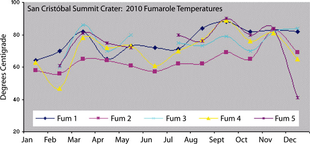 |
Figure 18. Fumarole temperatures from San Cristóbal measured throughout 2010 by INETER scientists. Note some data gaps for Fumarole 5 and Fumarole 3. Courtesy of INETER. |
Table 3. The date, local magnitude (ML), and depth to epicenters are listed for significant earthquakes located near San Cristóbal. No locations were determined for January and February 2010 or November and December 2011. Courtesy of INETER.
| Date | ML | Depth (km) |
| 09 Mar 2010 | 4.4 | 1 |
| 08 Apr 2010 | 3.1 | 0 |
| 08 Apr 2010 | 2.9 | 23 |
| 09 Apr 2010 | 2.5 | 3 |
| 29 Apr 2010 | 3.7 | 169 |
| 30 May 2010 | 2.6 | 1 |
| 04 Jun 2010 | 2.7 | 2 |
| 18 Sep 2010 | 2.0 | 0 |
| 18 Oct 2010 | 2.1 | 0 |
| 02 Jan 2011 | 2.3 | 2 |
| 10 Jan 2011 | 3.5 | 61 |
| 11 Feb 2011 | 2.2 | 5 |
| 19 Feb 2011 | 2.6 | 2 |
| 01 Apr 2011 | 1.3 | 2 |
| 02 Apr 2011 | 3.2 | 5 |
| 02 Apr 2011 | 3.1 | 5 |
| 02 Apr 2011 | 2.8 | 4 |
| 17 Apr 2011 | 2.8 | 1 |
| 11 Jun 2011 | 2.1 | 2 |
| 24 Jun 2011 | 2.2 | 4 |
| 24 Jul 2011 | 1.7 | 1 |
| 14 Aug 2011 | 2.0 | 2 |
| 02 Oct 2011 | 2.3 | 1 |
| 14 Oct 2011 | 2.5 | 2 |
| 15 Oct 2011 | 2.9 | 2 |
In May and June 2010 San Cristóbal was relatively quiet. Field measurements determined that fumarole temperatures were variable. The 3-station Mini-DOAS array detected relatively low levels of sulfur dioxide; INETER reported 274 tons/day (table 4). Visual observations determined that degassing was more vigorous in June and, while banded tremor had been recorded in May, seismicity was also higher in June. On 15 June, more than 12 hours of tremor were recorded.
Table 4. The average SO2 flux per sampling period in metric tons per day from San Cristóbal measured with Mini-DOAS from May 2010 to September 2011. Courtesy of INETER.
| Month | Metric Tons/day SO2 |
| May 2010 | 274 |
| Jul 2010 | 1248 |
| Dec 2010 | 460 |
| Jan 2011 | 659 |
| Sep 2011 | 1532 |
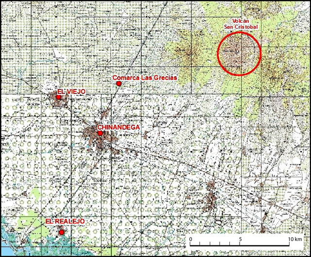
Significant ashfall from 2 July explosions. Elevated seismicity continued into July 2010 and was dominated by low-amplitude events. On 2 July an explosion from the summit crater released a low-altitude plume of ash (described as a "mushroom cloud" in news reports) that drifted over villages located W of the volcano. Local residents heard explosions and observed a dense ash plume sustained for ~20 minutes. Ash was accompanied by ejected incandescent blocks (reporters noted that block sizes were up to 10 meters in diameter) that scattered across the summit area and started grass fires. Field investigations by INETER on 24 July found that light ash had remained on foliage and grass and there were charred trees below the summit area. Civil Protection noted that ashfall had reached these towns and districts within a 10 km radius of the crater: Las Grecias, El Piloto, El Chonco, Mokorón, and Villa. Comarca Las Grecias is located WSW of San Cristóbal (figure 19).
Plumes and advisories. On 20 August 2010, a volcanic ash advisory was released for the N sector of San Cristóbal (table 5). The GOES-13 satellite detected a plume of gas and potentially light ash drifting from the summit over 35 km N. No associated activity was detected by local instrumentation that day although 10 minutes of tremor and several volcanic-tectonic (VT) events were recorded on 6 August. INETER field investigators visiting the summit on 22 August 2010 reported strong degassing and frequent rockfalls from the crater rim.
Table 5. Ash plumes from San Cristóbal reported by the Washington Volcanic Ash Advisory Center (VAAC) for June 2010 through August 2011. The 9 June event was the first to occur in 2010 and no additional reports were issued in 2011 after 21 August.
| Date | Altitude (km) | Drift |
| 09 Jun 2010 | 3.0 | WNW |
| 20 Aug 2010 | 3.0 | N |
| 15 Dec 2010 | 2.1 | -- |
| 17 Dec 2010 | 3.0 | N |
| 23 Dec 2010 | 1.8 | SW |
| 06 Jan 2011 | 2.1 | SW |
| 13 Jan 2011 | 2.1 | SW |
| 21 Aug 2011 | 6.1 | WNW |
Late 2010-early 2011 observations. Seismic activity in September 2010 was sparsely recorded due to intermittent equipment errors (local GPS malfunctioned) but seismicity from 21 September corroborated observations of activity from San Cristóbal. A series of small explosions occurred, beginning early on 21 September. Reports from Civil Defense based in Chinandega described rumbling sounds from the crater (lasting up to 20 minutes). Ashfall reached the regional capital as well as the town of El Viejo to the NW (figure 19).
INETER teams visited San Cristóbal in October and November 2010 and measured fumarole temperatures (figure 18). The team also observed strong gas emissions from the summit. Numerous rockfalls from the crater walls had occurred in October. Some tremor was recorded in October and sporadic seismicity continued into November. On 6 November, one hour of tremor was recorded. Earthquakes occurred more frequently toward the end of the month. Interesting sequences of VT events were recorded that lasted 15-20 minutes with frequencies of 3-5 Hz.
In early December 2010, seismicity gradually increased. Long-period events (LP) dominated the record and some VTs were recorded with frequencies of 1-3 Hz. Without any apparent precursory activity, a small explosion was recorded on 13 December at 0638 (figure 20).
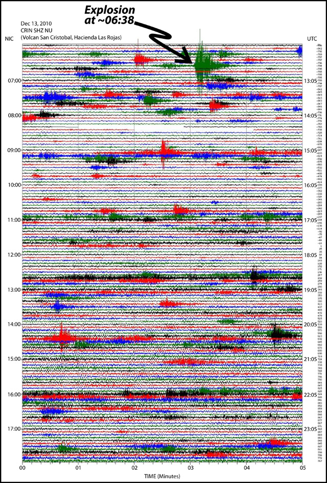 |
Figure 20. Seismicity on 13 December 2010 from San Cristóbal. The impulsive explosion was recorded at ~0638 from seismic station CRIN. Courtesy of INETER. |
An ash plume was reported by a local pilot at the time of the seismic signature. Elevated seismicity did not occur until after the explosion, when low-frequency tremor appeared in the records. Three subsequent volcanic ash advisories were issued by the Washington VAAC for the area on 15, 17, and 23 December (table 5).
Dense plumes of gas were emitted in early January 2011 and reported by Washington VAAC (table 5). Low-altitude plumes (2.1 km) and cloudless days provided excellent conditions for INETER scientists to detect SO2 flux on 21 January 2011. Traverses under the plume with a mobile Mini-DOAS collected data along points between Chinandega (SW of San Cristóbal) and Las Grecias (to the NW). INETER discussed the slight increase (~200 tons/day since December 2010, table 4) in SO2 in their monthly report and attributed elevated emissions to the general increase in seismicity during the last few months (table 3) and to changes in the volcano's structure.
Throughout 2011, field investigations by INETER included monitoring fumarole temperatures within the summit crater (figure 21). During 2011, temperatures from five separate fumaroles ranged between 50 and 90°C. Similar to measurements taken in 2010, intermittent values were recorded for Fumarole 5 (Fumarole 4 was also intermittent, no measurable value in June). Data collection was not possible in November and measurements in December clustered at comparatively elevated temperatures of 80 and 90°C.
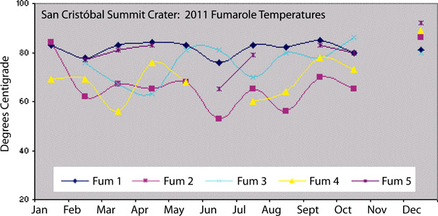 |
Figure 21. Fumarole temperatures from San Cristóbal measured throughout 2011 by INETER scientists. Some data gaps for Fumaroles 4 and 5; no measurements were taken in November. Courtesy of INETER. |
Within the summit crater during 2011, investigators found evidence of rockfalls as well as ground cracks at the crater rim. INETER described gradual accumulation of debris on the crater floor from February through April. During a field visit in May, two small pools of water had appeared within the crater. These features persisted from May through July.
Ash event without unrest. A sudden ash explosion was reported by Chinandega Civil Defense at 1900 on 23 October 2011. Ash fell over Chinandega (the regional capital) as well as El Viejo, El Realejo, and the district of Las Grecias (figure 19). Minor tremor events occurred during the day but signals suggesting explosions were absent. Tremor continued to appear in the seismic record during November through the end of December.
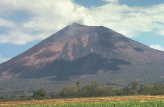
Geological Summary. The San Cristóbal volcanic complex, consisting of five principal volcanic edifices, forms the NW end of the Marrabios Range. The symmetrical 1745-m-high youngest cone, named San Cristóbal (also known as El Viejo), is Nicaragua's highest volcano and is capped by a 500 x 600 m wide crater. El Chonco, with several flank lava domes, is located 4 km W of San Cristóbal; it and the eroded Moyotepe volcano, 4 km NE of San Cristóbal, are of Pleistocene age. Volcán Casita, containing an elongated summit crater, lies immediately east of San Cristóbal and was the site of a catastrophic landslide and lahar in 1998. The Plio-Pleistocene La Pelona caldera is located at the eastern end of the complex. Historical eruptions from San Cristóbal, consisting of small-to-moderate explosive activity, have been reported since the 16th century. Some other 16th-century eruptions attributed to Casita volcano are uncertain and may pertain to other Marrabios Range volcanoes.
Information Contacts: Instituto Nicaragüense de Estudios Territoriales (INETER), Apartado Postal 2110, Managua, Nicaragua (URL: http://www.ineter.gob.ni/); Washington Volcanic Ash Advisory Center (VAAC), Satellite Analysis Branch (SAB), NOAA/NESDIS E/SP23, NOAA Science Center Room 401, 5200 Auth Rd, Camp Springs, MD 20746, USA (URL: http://www.ospo.noaa.gov/Products/atmosphere/vaac/); La Prensa (URL: http://www.laprensa.com.ni/2010/07/04/nacionales/30240); El Nuevo Diario (URL: http://www.elnuevodiario.com.ni/nacionales/78105).

